In June 2014 while on assignment for the Applied Technology Institute in Riva, Maryland, Logsdon and his professional colleague, Dr. Moha El-Ayachi, a professor at Rabat, Morocco, taught a group of international students who were flown into the United Nations Humanitarian Services Center in Brindisi, Italy. The students came in from such far-flung locales as […]
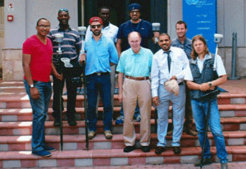
Instructor Tom Logsdon, turquoise shirt at front center, poses with some of his students at the United Nations Humanitarian Center located on the heel of the boot in Brindisi, Italy. Over a period of five days, the students learned how to use the GPS-based radio navigation system to survey their countries with extreme precision. The students and their instructors were flown into Brindisi by the United Nations from various other countries around the globe.
In June 2014 while on assignment for the Applied Technology Institute in Riva, Maryland, Logsdon and his professional colleague, Dr. Moha El-Ayachi, a professor at Rabat, Morocco, taught a group of international students who were flown into the United Nations Humanitarian Services Center in Brindisi, Italy. The students came in from such far-flung locales as Haiti, Liberia, Georgia, Western Sahara, the South Sudan, Germany, and Senegal to learn how to better survey land parcels in their various countries. Studies have shown that if clear, unequivocal boundaries defining property ownership can be assured to the citizens of a Third-World Country, financial prosperity inevitably follows. By mastering modern space-age surveying techniques using Trimble Navigation’s highly precise equipment modules, the international students were able to achieve quarter-inch (1 centimeter) accuracy levels for precise benchmarks situated all over the globe.
This was Logsdon’s second year of teaching the course in Brindisi and the Applied Technology Institute has already been invited to submit bids for another, similar course with the same two instructors for the spring of 2015. The students who converged on Brindisi were all fluent in English and well-versed in American culture. Their special skills were especially helpful to their instructors, Tom and Moha, who trained them to use the precisely timed navigation signals streaming down from the 31 GPS satellites circling the Earth 12,500 miles high.
The DOD’s Request for Proposal for the GPS navigation system was released in 1973.
Rockwell International won that contract to build 12 satellites with the total contract value of $330 million. Over the next dozen years, the company was awarded a total of $3 billion in contracts to build more than 40 GPS navigation satellites. Today 1 billion GPS navigation receivers are serving satisfied users all around the globe. The course taught by Tom and Moha covered a variety of topics of interest to specialized GPS users: What is the GPS? How does it work? What is the best way to build or select a GPS receiver? How is the GPS serving its user base? And how can specialize users find clever new ways accentuate its performance?
The GPS constellation currently consists of 31 satellites. That specialized constellation provides at least six-fold coverage to users everywhere in the world. Each of the GPS satellites transmits precisely timed electromagnetic pulses down to the ground, that require about one 11th of a second to make that quick journey. The electronic circuits inside the GPS receiver measure the signal travel time and multiply it by the speed of light to obtain the line-of-sight range to that particular satellite. When it has made at least four ranging measurements to a comparable number of satellites, the receiver employees a four-dimensional analogy of the Pythagorean theorem to determine its exact position and the exact time. This solution utilizes four equations in four unknowns: the receiver’s three position coordinates and the current time. The GPS system must keep track of time intervals to an astonishing level of precision. A radio wave moving through a vacuum travels a foot in a billionth of a second. So an accurate and effective GPS system must be able to keep track of time to within a few billionths of a second. This is accomplished by designing and building satellite clocks that are so accurate and reliable they would lose or gain only one second every 300,000 years. These amazingly accurate clocks are based on esoteric, but well-understood principles, from quantum mechanics. Despite their amazing accuracy, the clocks on board the GPS satellites must be re-synchronized using hardware modules situated on the ground three times each and every day.
The timing measurements for the GPS system are so accurate and precise Einstein’s two famous Theories of Relativity come into play. The GPS receivers located on or near the ground are in a one-g environment and they are essentially stationary compared the satellites whizzing overhead. A GPS satellite travels around its orbit at a speed of 8600 miles per hour and the gravity at its 12,500-mile altitude above the earth is only six percent as strong as the gravity being experienced by a GPS receiver situated on or near the ground. The difference in speed creates a systematic distortion in time due to Einstein’s Special Theory of Relativity. And the difference in gravitational attraction creates a systematic (and predictable) time distortion due to Einstein’s General Theory Of Relativity. If the designers of the GPS navigation system did not understand and compensate for these relativistic time-dilation effects, the GPS radionavigation system would, on average, be in error by about 7 miles. Fortunately, today’s scientists and engineers have gradually developed a firm grasp of the mathematics associated with relativity so they are able to make extremely accurate compensations to all of the GPS navigation solutions. The positions provided by the GPS, for rapidly moving users such as race cars and military airplanes, are typically accurate to within 15 or 20 feet. For the stationary benchmarks of interest to professional surveyors, the positioning solutions can be accurate to within one quarter of an inch, or about one centimeter.
Tom Logsdon has been teaching short courses for the Applied Technology Institute (www.ATIcourses.com) for more than 20 years. During that interval, he has taught nearly 300 short courses, most of which have spanned 3 to 5 days. His specialties include “Orbital and Launch Mechanics”, “GPS Technology”, “Team-Based Problem Solving”, and “Strapped-Down Inertial Navigation Systems”. Logsdon has written and sold 1.8 million words including 33 nonfiction books. These have included The Robot Revolution (Simon and Schuster), Striking It Rich in Space (Random House), The Navstar Global Positioning System (Van Nostrand Reinhold), Mobile Communications Satellites (McGraw-Hill), and Orbital Mechanics (John Wiley & Sons). All of his books have sold well, but his best-selling work has been Programming in Basic, a college textbook that, over nine printings, has sold 130,000 copies. Logsdon also, on occasion, writes magazine articles and newspaper stories and, over the years, he has written 18,000 words for Encyclopaedia Britannica. In addition, he has applied for a patent, help design an exhibit for the Smithsonian Institution, and helped write the text and design the illustrations for four full-color ads that appeared in the Reader’s Digest.
In 1973 Tom Logsdon received his first assignment on the GPS when he was asked to figure out how many GPS satellites would be required to provide at least fourfold coverage at all times to any receiver located anywhere on planet Earth. What a wonderful assignment for a budding young mathematician! Working in Technicolor— with colored pencils and colored marking pens on oversize quad-pad sheets four times as big as a standard sheet of paper— Logsdon used his hard-won knowledge of three-dimensional geometry, graphical techniques, and integral calculus to puzzle out the salient characteristics of the smallest constellation that would provide the necessary fourfold coverage. He accomplish this in three days— without using any computers! And the constellation he devised was the one that appeared in the winning proposal that brought in $330 million in revenues for Rockwell International.
Even as a young boy growing up wild and free in the Bluegrass Region of Kentucky, Tom Logsdon always seemed to have an intuitive understanding of and subtle mathematical relationships of the type that proved to be so useful in the early days of the American space program. His family had always been “gravel-driveway poor.” At age 18 he had never eaten in a restaurant; he had never stayed in a hotel; he had never visited a museum. But, somehow, he managed to work his way through Eastern Kentucky University as a math-physics major while serving as the office assistant to Dr. Smith Park, head of the mathematics department. He also worked as the editor of the campus newspaper, at a noisy Del Monte Cannery in Markesan, Wisconsin, and as a student trainee at the Naval Ordnance Laboratory in Silver Spring, Maryland.
Later he earned a Master’s Degree in Mathematics from the University of Kentucky where he wrote a regular column for the campus newspaper, played ping-pong with the number 9 competitor in the America, and specialized in a highly abstract branch of mathematics called combinatorial topology. In his 92-page thesis, jam-packed with highly abstract mathematical symbols, he evaluated the connectivity and orientation properties of simplicial and cell complexes and various multidimensional analogies of Veblin’s Theorem.
Soon after he finished his thesis, Logsdon accepted a position as a trajectory and orbital mechanics expert at Douglas Aircraft in Santa Monica, California. His most famous projects there included the giant 135 foot-in-diameter Echo Balloon, the six Transit Navigation Satellites, the Thor-Delta booster, and the third stage of the Saturn V moon rocket. A few years later, he moved on to Rockwell International in Downey, California, where he worked his mathematical magic on the second stage of the Saturn V, the four manned Skylab missions, the 24-satellite constellation of GPS radionavigation satellites, the manned Mars mission of 2016, various unmanned asteroid and comet probes, and the solar-power satellite project which, if it had reached fruition, would have incorporated at least 100 geosynchronous satellites each with a surface area equal to that of Manhattan Island (about 20 square miles).
Among his proudest accomplishments at Rockwell International was the clever utilization of nine different branches of advanced mathematics, in partnership with his friend, Bob Africano, to increase the performance capabilities of the Saturn V moon rocket by 4700 extra pounds of payload bound for the moon — each pound of which was worth five times its weight in 24 karat gold! These important performance gains were accomplished without changing any of the hardware elements on the rocket. Logsdon and Africano, instead, employed their highly specialized knowledge of mathematics and physics to work out ways to operate the mighty Saturn V more efficiently. This involved shaping the trajectories of the rocket for maximum propulsive efficiency, shifting the burning mixture ratio in mid flight in an optimal manner, and analyzing their six-degree-of-freedom post-flight trajectory simulations to minimize the heavy reserve propellants necessary to assure completion of the mission. These powerful breakthroughs in math and physics led to a saving of $3.5 billion for NASA – an amount equal to the lifetime earnings of 2000 average American workers!
Currently, Logsdon and his wife, Cyndy, live in Seal Beach, California. Logsdon is now retired from Rockwell International, but he is still writing books, acting as an expert witness in a variety of aerospace-related legal cases, lecturing professionally at big conventions, and teaching short courses on rocket science, orbital mechanics, and GPS technology at major universities, NASA bases, military installations, and at a variety of international locations. Prior to his recent trips to Italy, Logsdon delivered two lectures at Hong Kong University in southern China and taught two short courses at Stellenbach University near Cape Town, South Africa. Over the past 30 years or so he has taught and lectured at 31 different countries scattered across six continents. At the International Platform Association meetings in Washington, DC, two of his presentations in successive years placed in the top 10 among the 45 professional platform lecturers making presentations there. Colleges and Universities that have sponsored his presentations have included Johns Hopkins, Berkeley, USC, Oxford, North Texas University, the International Space University in Strasbourg, France, Saddleback.
3 thoughts on “Applied Technology Institute Instructor, Tom Logsdon, Helps International Surveyors Master Their Craft”
You need too take paet in a contest for one off the
greatest websites on the net. I will highly recommend
this blog!
Amazing things here. I am very happy to look your post.
Thank you so much and I am having a look ahead to contact you.
Will you please drop me a mail?
My brother suggested I may like this blog. He used to be
totally right. Thhis publish truly made my day. You can not consider
just how sso much tume I had spent for this info! Thank you!
Comments are closed.
Cookie Consent
We use cookies to improve your experience on our site. By using our site, you consent to cookies.
Contains information related to marketing campaigns of the user. These are shared with Google AdWords / Google Ads when the Google Ads and Google Analytics accounts are linked together.
90 days
__utma
ID used to identify users and sessions
2 years after last activity
__utmt
Used to monitor number of Google Analytics server requests
10 minutes
__utmb
Used to distinguish new sessions and visits. This cookie is set when the GA.js javascript library is loaded and there is no existing __utmb cookie. The cookie is updated every time data is sent to the Google Analytics server.
30 minutes after last activity
__utmc
Used only with old Urchin versions of Google Analytics and not with GA.js. Was used to distinguish between new sessions and visits at the end of a session.
End of session (browser)
__utmz
Contains information about the traffic source or campaign that directed user to the website. The cookie is set when the GA.js javascript is loaded and updated when data is sent to the Google Anaytics server
6 months after last activity
__utmv
Contains custom information set by the web developer via the _setCustomVar method in Google Analytics. This cookie is updated every time new data is sent to the Google Analytics server.
2 years after last activity
__utmx
Used to determine whether a user is included in an A / B or Multivariate test.
18 months
_ga
ID used to identify users
2 years
_gali
Used by Google Analytics to determine which links on a page are being clicked
30 seconds
_ga_
ID used to identify users
2 years
_gid
ID used to identify users for 24 hours after last activity
24 hours
_gat
Used to monitor number of Google Analytics server requests when using Google Tag Manager
1 minute
Vimeo is a video hosting platform for high-quality content, ideal for creators and businesses to showcase their work.
You need too take paet in a contest for one off the
greatest websites on the net. I will highly recommend
this blog!
Amazing things here. I am very happy to look your post.
Thank you so much and I am having a look ahead to contact you.
Will you please drop me a mail?
My brother suggested I may like this blog. He used to be
totally right. Thhis publish truly made my day. You can not consider
just how sso much tume I had spent for this info! Thank you!