Applied Technology Institute (ATICourses) offers Unmanned Air Vehicle Design and Unmanned Aircraft System Fundamentals courses. The information below could be of interest to our readers. The idea of thousands of drones buzzing high above Main Street, USA may sound just a bit too odd for most people. But according to the FAA, the future is already here. […]

Applied Technology Institute (ATICourses) offers
Unmanned Air Vehicle Design and
Unmanned Aircraft System Fundamentals courses. The information below could be of interest to our readers.
The idea of thousands of drones buzzing high above Main Street, USA may sound just a bit too odd for most people. But according to the FAA, the future is already here.
The Federal Aviation Administration (FAA) predicts that swarms of unmanned aircraft systems could be taking to the skies of America in the next five years, with up to 10,000 active commercial unmanned aircraft systems (UAS) patrolling from above by 2020.
Looking at aeronautical trends up to 2032, the FAA projects rapid growth of the UAS industry.
“In the United States alone, over 50 companies, universities, and government organizations are developing and producing some 155 unmanned aircraft designs,” according to the agency.
In February, the FAA said it had issued 1,428 permits to domestic drone operators since 2007, a number that far exceeds previous certifications. Meanwhile, some 327 permits are listed as active.
This startling rate of growth of a potentially pervasive technology has rights groups expressing concern over privacy issues and the potential for abuse of power.
Also, Even when controlled by skilled, well-intentioned operators, drones can pose a hazard—that’s what the FAA is concerned about. The safety record of military drones is not reassuring. Since 2001, according to the Air Force, its three main UAVs—the Predator, Global Hawk, and Reaper—have been involved in at least 120 “mishaps,” 76 of which destroyed the drone.
What is your opinion on the drones? Please comment below.
There is no doubt that the use of unmanned aircrafts or drones has seen a tremendous growth over the last few years. Since 2005 there has been a 1,200% increase in combat air patrols by UAVs. Al-Qaeda leader Anwar al-Awlaki was killed by a drone only last month. But does this mean that the future […]
There is no doubt that the use of unmanned aircrafts or drones has seen a tremendous growth over the last few years. Since 2005 there has been a 1,200% increase in combat air patrols by UAVs. Al-Qaeda leader Anwar al-Awlaki was killed by a drone only last month. But does this mean that the future belongs to UAS? What are the pros and cons of using unmanned aircraft vehicles vs manned?
 What are the pros and cons of UAVs?
Pros include:
1) significantly lower cost compared to manned vehicles (although they can get pretty expensive depending on their sophistication); this should allow the military to buy UAVs in much larger quantities than manned aircraft
2) expendability, you can afford to send them into heavily defended areas and risk losing some without endangering a pilot
3) more maneuverable than manned planes without the limitations of a human pilot
4) can be built stealthier than a manned plane since one of the least stealthy parts of the aircraft (the cockpit) is unnecessary
5) should be lighter, smaller, and easier to transport
Cons include:
1) limitations of their programming, may not be able to compensate for the changing battlefield environment (such as being able to attack a new more desirable target that appeared after the aircraft was launched or changing course to avoid enemy defenses)
2) because they are typically smaller than a manned plane, they cannot carry as large a payload (however, they do generally have a greater ratio of payload to total weight)
3) along the same lines, they may not be able to carry as much fuel and therefore may have a shorter range
4) typically tailored to specific kinds of missions and not as versatile as a modern multi-role fighter
5) if contact is lost with a ground station, the vehicle may be lost
Overall, but the pilot in the cockpit is already an endangered species.
What is your opinion? Please comment below.
Read more
here.
Tony White, Owner at Galaxy Blimps LLC and a member of my LinkedIn UAS group, is quoted extensively in this article. I used to work for an airship startup called SkyStation International and they do have their advantages (and disadvantages to be sure). They (and aerostats) also work well with UAS. Going back as far […]
Tony White, Owner at Galaxy Blimps LLC and a member of my LinkedIn UAS group, is quoted extensively in this article.
I used to work for an airship startup called SkyStation International and they do have their advantages (and disadvantages to be sure).
They (and aerostats) also work well with UAS.
Going back as far as the American Civil War,lighter-than-air vehicles — airships, hot air balloons, and aerostats — have performed a variety of missions for the military.
During World War I large military airships dropped bombs and performed surveillance. For a brief period of time in the 1930s the U.S. explored using them as “flying aircraft carriers,” says Ron Browning business development lead for persistent surveillance at Lockheed Martin Mission Systems & Sensors in Akron, Ohio.
Today, U.S. forces deploy these floating platforms as eyes in the sky in Iraq, Afghanistan, and around the world to perform persistent surveillance, which means missions that last days, weeks, and even months up in the air.
“Persistent surveillance is around the clock — 24/7 — monitoring for an extended period of time, monitoring that is in stark contrast to that provided by aircraft, which have surveillance-time limitations dictated by fuel consumption/capacity,” says Maj. Robert Rugg, assistant product manager persistent surveillance devices for the U.S. Army Program Manager Robotic and Unmanned Systems office in Huntsville, Ala.
There are two main types of lighter-than-air vehicles used or in development for military operations — airships and aerostats, Browning says. “An aerostat is tethered while an airship is free flying,” he explains.
Two free-flying programs in development are the High Altitude Airship (HAA) being developed by Browning’s team at Lockheed Martin and the Long Endurance Multi-Intelligence Vehicle (LEMV), being designed by Northrop Grumman in Melbourne, Fla., for medium altitudes, Browning says. They are both airship platforms.
Aerostats
The most deployed vehicles at the moment are aerostats, which often are used with unmanned aircraft systems (UASs) or as a relatively inexpensive replacement to UASs to provide non-stop coverage of strategic areas.
“Aerostats are capable of continuous coverage over (typically) a fixed area in a wide range of operational weather conditions,” Rugg says. “UASs have a reduced operational environment and cannot continuously remain in the air for an extended period of time. However, the extended mobility provided by a UAS allows for a better view of a particular point of interest. In this way, each system is able to capitalize on its inherent advantage, while propping up the limiting aspects of the other — optimally, a force is able to utilize both systems as complementary to each other.
Aerostats and free-flying airships also are under consideration for border control instead of UASs, says Tony White, owner of Galaxy Blimps in Dallas — www.galaxyblimps.com. A UAS does not work as well on the border due to the coverage advantages that a host of aerostats airships would have, he continues.
While not easy at first to steer aerostats are more rugged than one might think. “We also can launch into heavy winds, while UASs can’t,” White says. Even in 70 knot winds in Afghanistan, aerostats were able to hold their position in the mooring station, White says. Aerostats are not as vulnerable to enemy attack as one might assume, Browning says. “We’re flying at the upper limit to be vulnerable to small arms fire,” he adds.
 As Aerostats are low pressure systems so if a bullet hole or other hole pops up it “doesn’t go pop like a party balloon” Browning says. Instead the helium oozes out instead of gassing out, with degradation in lift altitude occurring over time instead of instantly, he explains. “It can fly when nothing else is flying,” Browning says.
“Despite the innovative nature of the systems, aerostats, in fact, have the great advantage of payload integration and flight qualification timelines that are much shorter than that of other aircraft,” Rugg continues. “Moreover, aerostats are typically more flexible in terms of the payloads they are able to carry. Weight limitations are the paramount issue with aerostats; some aircraft have lots of available size, weight, and power (SWAP).”
Persistent threat detection
One aerostat program currently seeing action in Iraq and Afghanistan is the Army’s Persistent Threat Detection System (PTDS), which has been deployed in Iraq and Afghanistan during Operation New Dawn and Operation Enduring Freedom respectively, Browning says. PTDS is run by Rugg’s team in Huntsville produced by prime contractor Lockheed Martin.
PTDS is a tethered system, which flies like a kite with no propulsion, Browning says. The system, first deployed by the Army in 2004, is a 74,000-cubic-foot envelope full of helium and aerodynamically-shaped always pointed into the wind with fins and a tail system and is always buoyant, he adds. The maximum altitude is 5,000 feet above ground level, Browning says.
“PTDS has the unique sustained operations capability that exceeds 20 continuous days,” Rugg notes.
The system carries one or two electro-optic/infrared (EO/IR) sensor payloads as well as other communications payloads, Rugg says. The EO sensors are mostly commercial-off-the-shelf (COTS), he adds. The EO/IR payload — the MX-20 Lite from L-3 Wescam in Toronto, Ontario — is attached on the underside of the aerostat, Browning says.
The MX-20 is a turret system that uses high-definition technology, says Paul Jennison, vice president of business development for L-3 Wescam. Included in the system is digital infrared capability, a color daylight camera, mono camera for night, and lasers for range finding and illumination — that illuminates targets for ground for troops who have night vision goggles, he continues.
The only real adjustment made for the aerostat application was adding a heat exchanger for thermal management in the static air, Jennison says. “Our system also has gone through the full spectrum of MIL-STD testing for humidity, salt, fog, and dust environments,” he adds.
The PTDS communication links have extended range for deployed troops, Browning says. The sensor can provide full-motion vision to the warfighter on the ground. “Imagine the value of that to combat teams,” Browning adds.
“Based on experience in theater, a second EO/IR sensor has been added. Furthermore, due to on site weather conditions, lightning detection equipment has been added, as well as the ability to broadcast video to mobile troops carrying OSRVT (One System Remote Video Terminal),” Rugg says. “Additionally, the mooring system has been modularized to allow transport to more remote forward operating bases.”
As Aerostats are low pressure systems so if a bullet hole or other hole pops up it “doesn’t go pop like a party balloon” Browning says. Instead the helium oozes out instead of gassing out, with degradation in lift altitude occurring over time instead of instantly, he explains. “It can fly when nothing else is flying,” Browning says.
“Despite the innovative nature of the systems, aerostats, in fact, have the great advantage of payload integration and flight qualification timelines that are much shorter than that of other aircraft,” Rugg continues. “Moreover, aerostats are typically more flexible in terms of the payloads they are able to carry. Weight limitations are the paramount issue with aerostats; some aircraft have lots of available size, weight, and power (SWAP).”
Persistent threat detection
One aerostat program currently seeing action in Iraq and Afghanistan is the Army’s Persistent Threat Detection System (PTDS), which has been deployed in Iraq and Afghanistan during Operation New Dawn and Operation Enduring Freedom respectively, Browning says. PTDS is run by Rugg’s team in Huntsville produced by prime contractor Lockheed Martin.
PTDS is a tethered system, which flies like a kite with no propulsion, Browning says. The system, first deployed by the Army in 2004, is a 74,000-cubic-foot envelope full of helium and aerodynamically-shaped always pointed into the wind with fins and a tail system and is always buoyant, he adds. The maximum altitude is 5,000 feet above ground level, Browning says.
“PTDS has the unique sustained operations capability that exceeds 20 continuous days,” Rugg notes.
The system carries one or two electro-optic/infrared (EO/IR) sensor payloads as well as other communications payloads, Rugg says. The EO sensors are mostly commercial-off-the-shelf (COTS), he adds. The EO/IR payload — the MX-20 Lite from L-3 Wescam in Toronto, Ontario — is attached on the underside of the aerostat, Browning says.
The MX-20 is a turret system that uses high-definition technology, says Paul Jennison, vice president of business development for L-3 Wescam. Included in the system is digital infrared capability, a color daylight camera, mono camera for night, and lasers for range finding and illumination — that illuminates targets for ground for troops who have night vision goggles, he continues.
The only real adjustment made for the aerostat application was adding a heat exchanger for thermal management in the static air, Jennison says. “Our system also has gone through the full spectrum of MIL-STD testing for humidity, salt, fog, and dust environments,” he adds.
The PTDS communication links have extended range for deployed troops, Browning says. The sensor can provide full-motion vision to the warfighter on the ground. “Imagine the value of that to combat teams,” Browning adds.
“Based on experience in theater, a second EO/IR sensor has been added. Furthermore, due to on site weather conditions, lightning detection equipment has been added, as well as the ability to broadcast video to mobile troops carrying OSRVT (One System Remote Video Terminal),” Rugg says. “Additionally, the mooring system has been modularized to allow transport to more remote forward operating bases.”
 In addition to the aerostat, tether, and sensor payload, PTDS also has a mobile mooring platform, mission payloads, ground-control station, maintenance and officer shelter, power generators, and site-handling equipment, Browning says.
The ground-control station for an aerostat is typically on site, Rugg says. These ground-control stations are not that different from that of a UAS ground station, and “include such elements as operator consoles, workstations, tactical setup. The operating crew for a ground station is the same crew that launches and recovers the aerostat,” he adds.
Most of the electronics in the ground-control station is COTS, Rugg says. “There are two workstations for command and control of EO/IR sensors, networking equipment, UPS, aerostat flight control and monitoring computer and display as well as an Unattended Transient Acoustic MASINT Sensor (UTAMS) computer. UTAMS is an acoustic fire-detection sensor capable of locating point of impact/origin of rockets, mortars, and improvised explosive devices (IEDs).”
High-altitude airships
Lockheed Martin’s HAA — being developed for the Army — will act as a surveillance platform, telecommunications relay, or a weather observer, Browning says. Different electro-optic sensor payloads will be configured for different intelligence, surveillance, and reconnaissance (ISR) missions, he continues. Once it reaches its location it can survey a 600-mile diameter and millions of cubic miles of airspace.
In April 2008, the HAA program transferred from the Missile Defense Agency to the U.S. Army Space and Missile Defense Command, located at Huntsville, Ala. The command designing the HAA to align with the command’s mission
“The big thing to understand is that no lighter than airship has ever flown more than a few hours at more than 60,000 feet,” let alone six months, Browning says. Conventional airships have demonstrated days of endurance in the past. Current blimps for sporting events can fly for 12 plus hours, depending on conditions, he adds.
The HAA will be about 500 feet long and 150 feet high, and be airborne for six months or more at a time, Browning says. It will be launched to an area of interest and park there, he continues. It will have a sensor communication link capability for deployed troops on field to get where they want to get to, Browning adds.
“We are currently developing and demonstrating the high altitude airship concept,” Browning says. The demonstration program is called the High Altitude Long Endurance-Demonstrator (HALE-D), he adds.
HALE-D will fly this summer air at an altitude of 60,000 ft and operating for a couple weeks using small, modest payload consistent with the demonstration, Browning says.
Free flying aircraft steer and navigate from one location to another so the all-electric HALE-D will need to operate at neutral buoyancy, Browning says. Goodyear blimps are always scary, taking off with heavy with fuel, which then burns, making the aircraft more light and buoyant.
In addition to the aerostat, tether, and sensor payload, PTDS also has a mobile mooring platform, mission payloads, ground-control station, maintenance and officer shelter, power generators, and site-handling equipment, Browning says.
The ground-control station for an aerostat is typically on site, Rugg says. These ground-control stations are not that different from that of a UAS ground station, and “include such elements as operator consoles, workstations, tactical setup. The operating crew for a ground station is the same crew that launches and recovers the aerostat,” he adds.
Most of the electronics in the ground-control station is COTS, Rugg says. “There are two workstations for command and control of EO/IR sensors, networking equipment, UPS, aerostat flight control and monitoring computer and display as well as an Unattended Transient Acoustic MASINT Sensor (UTAMS) computer. UTAMS is an acoustic fire-detection sensor capable of locating point of impact/origin of rockets, mortars, and improvised explosive devices (IEDs).”
High-altitude airships
Lockheed Martin’s HAA — being developed for the Army — will act as a surveillance platform, telecommunications relay, or a weather observer, Browning says. Different electro-optic sensor payloads will be configured for different intelligence, surveillance, and reconnaissance (ISR) missions, he continues. Once it reaches its location it can survey a 600-mile diameter and millions of cubic miles of airspace.
In April 2008, the HAA program transferred from the Missile Defense Agency to the U.S. Army Space and Missile Defense Command, located at Huntsville, Ala. The command designing the HAA to align with the command’s mission
“The big thing to understand is that no lighter than airship has ever flown more than a few hours at more than 60,000 feet,” let alone six months, Browning says. Conventional airships have demonstrated days of endurance in the past. Current blimps for sporting events can fly for 12 plus hours, depending on conditions, he adds.
The HAA will be about 500 feet long and 150 feet high, and be airborne for six months or more at a time, Browning says. It will be launched to an area of interest and park there, he continues. It will have a sensor communication link capability for deployed troops on field to get where they want to get to, Browning adds.
“We are currently developing and demonstrating the high altitude airship concept,” Browning says. The demonstration program is called the High Altitude Long Endurance-Demonstrator (HALE-D), he adds.
HALE-D will fly this summer air at an altitude of 60,000 ft and operating for a couple weeks using small, modest payload consistent with the demonstration, Browning says.
Free flying aircraft steer and navigate from one location to another so the all-electric HALE-D will need to operate at neutral buoyancy, Browning says. Goodyear blimps are always scary, taking off with heavy with fuel, which then burns, making the aircraft more light and buoyant.
 One way to avoid that problem at take off is by having all-electric system that uses solar energy panels and stores the energy in batteries or rechargeable fuel cells for night flying. Propulsion units will lift the HALE-D aloft and guide its takeoff and landing during, Browning says.
The long-term operational goal — beyond the HALE-D is large with more than ton of payload onboard the HAA, Browning says. The large payload berth provides a lot of flexibility in payload design and capability, he continues. “It can really open the imagination of the sensor designer,” Browning adds.
The sensor technology is already available on a lot of aircraft, Browning says. However as with some existing airborne and spaceborne platforms the biggest challenge is reliability. Once the system is launched it won’t be brought down for several months, so you need sensors that last in tough environments.
The HALE-D sensors include a Thales MMAR modem, an L-3 Communications mini CDL, and an electro-optical system from ITT Geospatial Systems in Rochester, N.Y., Browning says.
ITT provided a long focal-length panchromatic electro-optical (EO) camera with GPS/Inertial Navigation System (INS) and pointing capability for the HALE-D program, says David A. Parkes, senior business development manager at ITT Geospatial Systems.
“An unmanned high-altitude platform does bring unique challenges in designing EO solutions,” Parkes says. “First, it’s very high flight altitudes bring very cold temperatures as low as -50 degrees Celsius and little air, which makes it challenging to both start up and maintaining proper electronics temperatures. It is more space-like than airborne. The ascent to these high altitudes also drives the need for all components to be able to outgas, so they are not damaged (e.g. optical lens). The second challenge is that current payload capacities for high altitude platforms are relatively small, which drives the need for very light weight and low power payloads.”
“The objectives and funding of this EO system were primarily for functional demonstration on this exciting high-altitude platform,” Parkes continues. “This drove a highly COTS-based solution. Future high-altitude EO systems will require designs that provide higher performance and high reliability that will leverage space systems designs without space system costs.”
Long-endurance airships
Northrop Grumman’s LEMV program completed its critical design review (CDR) six months after signing the agreement with the U.S. Army. Under that agreement the company will build three airships with 21-day persistent ISR capability, according to a Northrop Grumman release. Northrop Grumman officials declined to be interviewed for this story.
One way to avoid that problem at take off is by having all-electric system that uses solar energy panels and stores the energy in batteries or rechargeable fuel cells for night flying. Propulsion units will lift the HALE-D aloft and guide its takeoff and landing during, Browning says.
The long-term operational goal — beyond the HALE-D is large with more than ton of payload onboard the HAA, Browning says. The large payload berth provides a lot of flexibility in payload design and capability, he continues. “It can really open the imagination of the sensor designer,” Browning adds.
The sensor technology is already available on a lot of aircraft, Browning says. However as with some existing airborne and spaceborne platforms the biggest challenge is reliability. Once the system is launched it won’t be brought down for several months, so you need sensors that last in tough environments.
The HALE-D sensors include a Thales MMAR modem, an L-3 Communications mini CDL, and an electro-optical system from ITT Geospatial Systems in Rochester, N.Y., Browning says.
ITT provided a long focal-length panchromatic electro-optical (EO) camera with GPS/Inertial Navigation System (INS) and pointing capability for the HALE-D program, says David A. Parkes, senior business development manager at ITT Geospatial Systems.
“An unmanned high-altitude platform does bring unique challenges in designing EO solutions,” Parkes says. “First, it’s very high flight altitudes bring very cold temperatures as low as -50 degrees Celsius and little air, which makes it challenging to both start up and maintaining proper electronics temperatures. It is more space-like than airborne. The ascent to these high altitudes also drives the need for all components to be able to outgas, so they are not damaged (e.g. optical lens). The second challenge is that current payload capacities for high altitude platforms are relatively small, which drives the need for very light weight and low power payloads.”
“The objectives and funding of this EO system were primarily for functional demonstration on this exciting high-altitude platform,” Parkes continues. “This drove a highly COTS-based solution. Future high-altitude EO systems will require designs that provide higher performance and high reliability that will leverage space systems designs without space system costs.”
Long-endurance airships
Northrop Grumman’s LEMV program completed its critical design review (CDR) six months after signing the agreement with the U.S. Army. Under that agreement the company will build three airships with 21-day persistent ISR capability, according to a Northrop Grumman release. Northrop Grumman officials declined to be interviewed for this story.
 “The power of the LEMV system is that its persistent surveillance capability is built around Northrop Grumman’s open architecture design, which provides plug-and-play payload capability to the warfighter and room for mission growth,” says Alan Metzger, Northrop Grumman vice president and integrated program team leader of LEMV and airship programs in the company release. “The system rapidly accommodates next-generation sensors as emerging field requirements dictate and will provide increased operational utility to battlefield commanders. Today, our system readily integrates into the Army’s existing Universal Ground Control Station and Deployable Common Ground System command centers and ground troops in forward operating bases.
“While LEMV is longer than a football field and taller than a seven-story building, it utilizes approximately 3,500 gallons of fuel for the air vehicle to remain aloft for a 21-day period of service, that’s approximately $11,000 at commercial prices.
“We’ll have hull inflation in the spring and first flight of the airship test article by mid-to-late summer,” he says. Upon completion of the development ground and flight testing phase, we expect to transition to a government facility and conduct our final acceptance long endurance flight just before year’s end. In early 2012, LEMV will participate in an Army Joint Military Utility Assessment in an operational environment.”
Northrop Grumman’s industry team includes Hybrid Air Vehicles, Ltd. of the England, Warwick Mills, ILC Dover, AAI Corp., SAIC in McLean, Va., and a team of organizations from 18 U.S. states and three countries. In addition to leading the program, Northrop Grumman leads the system integration, and flight and ground control operations for the unmanned vehicle.
http://www.militaryaerospace.com/index/display/article-display/2737597448/articles/military-aerospace-electronics/exclusive-content/2011/3/persistent-surveillance.html
“The power of the LEMV system is that its persistent surveillance capability is built around Northrop Grumman’s open architecture design, which provides plug-and-play payload capability to the warfighter and room for mission growth,” says Alan Metzger, Northrop Grumman vice president and integrated program team leader of LEMV and airship programs in the company release. “The system rapidly accommodates next-generation sensors as emerging field requirements dictate and will provide increased operational utility to battlefield commanders. Today, our system readily integrates into the Army’s existing Universal Ground Control Station and Deployable Common Ground System command centers and ground troops in forward operating bases.
“While LEMV is longer than a football field and taller than a seven-story building, it utilizes approximately 3,500 gallons of fuel for the air vehicle to remain aloft for a 21-day period of service, that’s approximately $11,000 at commercial prices.
“We’ll have hull inflation in the spring and first flight of the airship test article by mid-to-late summer,” he says. Upon completion of the development ground and flight testing phase, we expect to transition to a government facility and conduct our final acceptance long endurance flight just before year’s end. In early 2012, LEMV will participate in an Army Joint Military Utility Assessment in an operational environment.”
Northrop Grumman’s industry team includes Hybrid Air Vehicles, Ltd. of the England, Warwick Mills, ILC Dover, AAI Corp., SAIC in McLean, Va., and a team of organizations from 18 U.S. states and three countries. In addition to leading the program, Northrop Grumman leads the system integration, and flight and ground control operations for the unmanned vehicle.
http://www.militaryaerospace.com/index/display/article-display/2737597448/articles/military-aerospace-electronics/exclusive-content/2011/3/persistent-surveillance.html

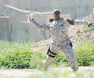
MONROVIA, Calif., December 28, 2010 — AeroVironment, Inc. (AV) (NASDAQ:AVAV) announced today that it received an order valued at $46,226,984 under an existing contract with the U.S. Army. The order comprises 123 new digital Raven® small unmanned aircraft systems (UAS) and initial spares packages as well as 186 digital retrofit kits for the U.S. Marine […]
MONROVIA, Calif., December 28, 2010 — AeroVironment, Inc. (AV) (NASDAQ:AVAV) announced today that it received an order valued at $46,226,984 under an existing contract with the U.S. Army. The order comprises 123 new digital Raven® small unmanned aircraft systems (UAS) and initial spares packages as well as 186 digital retrofit kits for the U.S. Marine Corps. The order also includes 339 digital retrofit kits for the U.S. Army. The Raven system and retrofit order represents the remainder of the funds appropriated for RQ-11B Raven system procurement in the 2010 Department of Defense Appropriations Act, which was signed into law in December 2009.
The orders were released under the existing U.S. Army joint small UAS program of record for AV’s Raven. This program has included contract additions from the Army, Marine Corps and Special Operations Command. The items and services provided under these awards on this multi-year contract are fully funded. Work is scheduled to be performed within a period of 12 months.
“Raven systems have proven their value and reliability to military services across the U.S. Department of Defense,” said Tom Herring, AV senior vice president and general manager, Unmanned Aircraft Systems. “These backpackable, hand-launched unmanned systems provide situational awareness directly to our warfighters, increasing mission effectiveness and safety. We remain focused on supporting our customers with reliable solutions and developing ever more capable solutions.”
The Raven unmanned aircraft is a 4.2-pound, backpackable, hand-launched sensor platform that provides day and night, real-time video imagery for “over the hill” and “around the corner” reconnaissance, surveillance and target acquisition in support of tactical units. U.S. armed forces use Raven systems extensively for missions such as base security, route reconnaissance, mission planning and force protection. Each Raven system typically consists of three aircraft, two ground control stations and spares.
In addition to the Raven system, AV’s small UAS include Puma™ and Wasp™, which are also hand-launched and controlled by AV’s hand-held ground control station. Each aircraft in AV’s family of small UAS is interoperable and tailored to address a variety of operational user needs. AV’s UAS logistics operation supports systems deployed worldwide to ensure a consistently high level of operational readiness. AV has delivered thousands of small unmanned aircraft to date. International purchasers of Raven systems include Italy, Denmark, the Netherlands, Spain and Norway.
 The Raven unmanned aircraft is a 4.2-pound, backpackable, hand-launched sensor platform that provides day and night, real-time video imagery for “over the hill” and “around the corner” reconnaissance, surveillance and target acquisition in support of tactical units.
 |
http://www.spacewar.com/reports/AeroVironment_Receives_Order_For_Raven_UAS_And_Digital_Retrofit_Kits_999.html
The Australian Research Centre for Aerospace Automation’s (ARCAA) Smart Skies project, focusing on the development of technology to enable manned and unmanned aircraft to effectively share airspace, is approaching its final milestone. The project, also involving Boeing Research and Technology-Australia, Insitu Pacific and the Queensland Government, is exploring development of three key enabling aviation technologies: […]
The Australian Research Centre for Aerospace Automation’s (ARCAA) Smart Skies project, focusing on the development of technology to enable manned and unmanned aircraft to effectively share airspace, is approaching its final milestone.
The project, also involving Boeing Research and Technology-Australia, Insitu Pacific and the Queensland Government, is exploring development of three key enabling aviation technologies: an Automated Separation Management System capable of providing separation assurance in complex airspace environments; Sense and Act systems for manned and unmanned aircraft capable of collision avoidance of dynamic and static obstacles; and a Mobile Aircraft Tracking System (MATS) utilising a cost-effective radar and dependent surveillance systems.
The latest flight trials included all of the project elements, including a fixed-wing UAV and a modified Cessna flying in automatic mode, flying collision scenarios with simulated aircraft.
The final flight trial will take place in December this year, before project wrap-up and final reports in 2011, and, ultimately, the attempt to commercialise the Smart Skies intellectual property.
ARCAA acting director Dr Jonathon Roberts said a new research project was also on the cards. The collision-avoidance research is one of two key areas in which the Civil Aviation Safety Authority (CASA) requires proof that technology in unmanned aircraft can operate in a way equivalent to human pilots.
“In the future research we’re trying to hit the next problem: Smart Skies is all about collision avoidance and managing the avoidance of collisions; the next thing that CASA will require will be automatic landing systems,” Dr Roberts said. “So that if you have an engine failure or other catastrophic failure and you have to come down, you’ve got to be able to put it down in a safe place, so these will be vision systems that actually look at the ground and figure out where to land.
“That’s the next thing that has to be done before UAVs can fly over populous areas.”
The Smart Skies program was recently recognised at the Queensland Engineering Excellence Awards, where it won the ‘Control systems, networks, information processing and telecommunications’ category.
Is this phased approach (land, then move away) a viable first step for the safe integration of UAVs into non-segregated airspace?
Is this phased approach (land, then move away) a viable first step for the safe integration of UAVs into non-segregated airspace?
Yesterday, instructor Mark Lewellen was explaining some of the background to UAVs: from aerial attacks on Venice through Marilyn Monroe to sizes of UAVs and likely future uses. If prospective attendees knew they would enjoy the thought-provoking subject half as much as I did, ATI would be running this course once a month.
Yesterday, instructor Mark Lewellen was explaining some of the background to UAVs: from aerial attacks on Venice through Marilyn Monroe to sizes of UAVs and likely future uses. If prospective attendees knew they would enjoy the thought-provoking subject half as much as I did, ATI would be running this course once a month.
ATIcourses has a new 1 day short course on Unmanned Aircraft Systems. A full description is at http://aticourses.com/unmanned_aircraft_systems.html What You Will Learn: Categories of current UAS and their aeronautical capabilities? Major manufactures of UAS? The latest developments and major components of a UAS? What type of sensor data can UAS provide? Regulatory and spectrum issues […]
ATIcourses has a new 1 day short course on Unmanned Aircraft Systems. A full description is at http://aticourses.com/unmanned_aircraft_systems.html
What You Will Learn:
- Categories of current UAS and their aeronautical capabilities?
- Major manufactures of UAS?
- The latest developments and major components of a UAS?
- What type of sensor data can UAS provide?
- Regulatory and spectrum issues associated with UAS?
- National Airspace System including the different classes of airspace
- How will UAS gain access to the National Airspace System (NAS)?
From this course you will gain practical knowledge to understand the different classes and types of UAS, optimize their specific applications, evaluate and compare UAS capabilities, interact meaningfully with colleagues, and master the terminology.
Facts and Figures on UAS
http://www.theuav.com/index.html#
UAS on Wikipedia
http://en.wikipedia.org/wiki/Unmanned_Aerial_Vehicle
UAV Forum
http://www.uavforum.com/index.shtml
DoD UAS Roadmap 2007-2032
http://www.fas.org/irp/program/collect/usroadmap2007.pdf
Shepard UVOnline
http://www.shephard.co.uk/news/category/1/uvonline/