Applied Technology Institute (ATI Courses) is scheduled to present the following Unmanned Aircraft Courses below. Unmanned Air Vehicle Design Sep 24-26, 2013 Columbia, MD Unmanned Air Vehicle Design Jan 28-30, 2014 Columbia, MD Unmanned Aircraft System Fundamentals Jul 23-25, 2013 Columbia, MD Unmanned Aircraft System Fundamentals Feb 25-27, 2014 Columbia, MD This is an article […]

Applied Technology Institute (ATI Courses) is scheduled to present the following Unmanned Aircraft Courses below.
Unmanned Air Vehicle Design Sep 24-26, 2013 Columbia, MD
Unmanned Air Vehicle Design Jan 28-30, 2014 Columbia, MD
Unmanned Aircraft System Fundamentals Jul 23-25, 2013 Columbia, MD
Unmanned Aircraft System Fundamentals Feb 25-27, 2014 Columbia, MD
This is an article that we think will be of interest to our students. It was written by
Alon Unger – UVID 2013 Conference Chairman – Israel – 10.10.2013and originally appeared at http://www.israeldefense.com/?CategoryID=472&ArticleID=1646
The global demand for unmanned systems, in conjunction with the high rate of technological progress in this field, often leads to these weapon systems being fielded before they reach operational and logistic maturity.
The rapid growth in the number of companies engaged in unmanned systems and the rapid technological progress made in the fields of miniaturization, electrooptics, communication, and computers, have led to a situation where state-of-the-art technology is installed in these systems. This, in turn, creates numerous challenges for everyone involved.
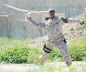
The most significant implication of the uniqueness of unmanned systems is that they are technology-intensive systems that make it possible to set advanced operational challenges and objectives in diversified operating environments. This requires that the personnel operating these systems have a high level of proficiency and professionalism. In addition, this proficiency includes numerous capabilities and skills beyond the mere steering of the airborne platform and the operation of the payloads.
In UAV systems (also called UAS – Unmanned Aerial Systems), which are controlled in real time, the operator normally occupies a remotely located ground control station where he must analyze the status of the system, the operational environment, and real-time occurrences through “remote control” sensing. He understands, for example, the weather conditions at a distance of tens to hundreds of kilometers, without being able to see the whole environment through the canopy, or identify a drop in engine thrust merely through the gauges, without physically sensing it. These seemingly simple tasks necessitate proficiency from a distance.
As part of current UAS development efforts, two prominent factors directly affect system operation. The first factor, which mainly affects the steering and system operation, provides advanced capabilities to the aircraft, including a higher degree of autonomy and automation, improved reliability, extended operation and communication ranges, and upgraded propulsion systems. In addition to simplifying system control, reducing the number of operators at the ground control station, and improving the basic safety standards, these technological capabilities often have the opposite effect on the operating aspect.
One example of a negative side effect is the deterioration in basic operator proficiency. This has the potential to damage the operator’s ability to cope with emergency situations, or in extreme cases, conceive the steering of the UAV as the operation of a flying model aircraft. This consequently affects the basic operator training standards (this conceptual error is typical made by countries taking their first steps into the field of unmanned systems).
The second factor, which mainly affects the mission and interpretation aspect, is improving and adding mission capabilities through new payloads or through the improvement of existing ones. This trend significantly raises the level of complexity for the operator. Today, operators are required to control multiple payload types (Electro-Optical, IR, SAR, EW, SIGINT) in different environments (close and long range, urban and open terrain, day and night, extreme weather conditions, and so forth), and be able to effectively execute a range of mission types. Such missions include intelligence collection, close surveillance support for advancing ground forces, battle damage assessment, and many others.
In the last decade, these factors were supplemented by the objective of reducing the number of operators at the ground control station. This process, whose primary objective is improved efficiency, does not necessarily improve mission performance, and often leads to an increased operating workload to the point of rendering mission execution impossible, or at times, failing to steer the UAV in a reasonably safe manner. For example, the majority of Mini-UAV systems boast the ability to have the mission executed by a single operator. Technically, this system operation is possible. However, a simple analysis of the operator’s functional characteristics will show that the mission environment and the number of simultaneous activities (system control, payload control, maintaining and tracking target contact, reporting, etc.) usually do not allow for the mission to be executed effectively and safely by a single operator.
This insight is further emphasized when the background of the operating personnel is less than optimal. This is currently the case in several countries around the world where the relevant authorities are not sufficiently stringent about screening and selecting the appropriate personnel for the execution of these systems and missions.
A review of the psychological aspect also suggests that UAV operators are unique. A US study published in 2009 examined the population of Predator (MQ-1) UAV operators in the US. The study established a correlation between the nature of their activity and extremely high levels of fatigue, sleep disorders, and stress. Other studies established a circumstantial correlation with high psychological pressures emanating from cognitive and emotional transitions in the operational daily routine of UAV operators and from the rapid leaps between the executions of critical operational missions over the battlefield to daily life with family.
The gamut of environmental, mission, and technological variables has made the operation of UAV systems much more complex than ever before.
UAV operators are required to be technically proficient in and professionally knowledgeable about numerous technological measures and different computer environments, all while having to meet their operational objectives in real time. Even for a seasoned, highly skilled operator, this constitutes a major challenge.
The following variables illustrate the range of capabilities and characteristics UAV operators are required to possess: multitasking, working under pressure and making decisions in real time, good spatial perception, teamwork, assertiveness, perseverance, patience, service awareness, work ethics, maturity, creativity, a methodical approach, and an ability to learn quickly. Accordingly, these implications should be reviewed through the aspects of selecting the operators, training them, maintaining their competence, assembling teams, developing careers, adding mission tools, assimilation, and legislation.
The Human Factor aspects are also particularly important in layouts and system engineering required to apply remote control operations, such as UAV systems. Most of the current studies that deal with analyzing the causes of UAV accidents and the performance standards of UAV systems have established that the human factor is the most influential element with regards to the two variables outlined above. To date, most UAV accidents are caused by failures linked to the human factor, such as faulty user interface design, operating errors, and other factors, all coming under the definition of “Human Error.”
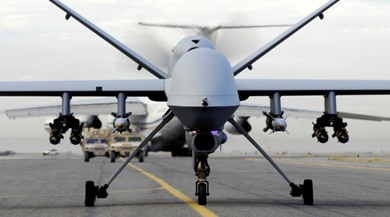
One prominent example of this is the investigation of the crash of the Predator B (MQ-9) UAV in Arizona on April 25, 2006. The National Transportation Safety Board, who investigated the accident, came up with numerous variables that may have caused the crash, most of which are linked to the human factor. One of the lessons drawn from this accident suggests that the phenomenon of gaps in this field far exceed the boundaries of this particular accident that are prevalent in all UAV systems.
Many years ago, Israel identified the Human Factor aspect as a primary factor in system performance and safety standards. Accordingly, for many years afterwards, human factor professionals were involved in the field of UAVs in Israel. However, even in Israel, the investments made in the effort to develop the system around the operator are in no way similar to the investments made in manned systems. This gap is especially evident on the ground, often because of the absence of specific standards for this field.
“The Human Behind the Unmanned System Will Make the Difference” is a slogan I invented many years ago. Since then, I have often been asked to explain it by using various aspects outlined in this article.
The complexity of UAV systems environment parameters, the technological race, and above all, the increasingly ambitious operational demands, are external variables that are likely to remain with us for many years to come. Understanding the central role that the human element plays in unmanned systems is a process that has just begun. As such, we must internalize the axiom “the system is only as good as its operator.”
In the last year, the US has begun to change their definitions of UAVs from “Unmanned Vehicles” to “Remotely Piloted Aircraft (RPA).” This trend, which amends the system manning issue, may lead to a change in the prevailing concept regarding the central role played by the human element, and could also lead to a change in Israel’s concepts and terminology. Nevertheless, it raises an historical debate of Pilot vs. Operators issue. Personally, I would recommend the term “Remotely Operated Aircraft” but this is an issue for another article.

 Aerial Torpedo attached to Aircraft
 General Atomics Predator RQ-1L UAV
 What are the pros and cons of UAVs?
Pros include:
What are the pros and cons of UAVs?
Pros include:
 As Aerostats are low pressure systems so if a bullet hole or other hole pops up it “doesn’t go pop like a party balloon” Browning says. Instead the helium oozes out instead of gassing out, with degradation in lift altitude occurring over time instead of instantly, he explains. “It can fly when nothing else is flying,” Browning says.
“Despite the innovative nature of the systems, aerostats, in fact, have the great advantage of payload integration and flight qualification timelines that are much shorter than that of other aircraft,” Rugg continues. “Moreover, aerostats are typically more flexible in terms of the payloads they are able to carry. Weight limitations are the paramount issue with aerostats; some aircraft have lots of available size, weight, and power (SWAP).”
Persistent threat detection
One aerostat program currently seeing action in Iraq and Afghanistan is the Army’s Persistent Threat Detection System (PTDS), which has been deployed in Iraq and Afghanistan during Operation New Dawn and Operation Enduring Freedom respectively, Browning says. PTDS is run by Rugg’s team in Huntsville produced by prime contractor Lockheed Martin.
PTDS is a tethered system, which flies like a kite with no propulsion, Browning says. The system, first deployed by the Army in 2004, is a 74,000-cubic-foot envelope full of helium and aerodynamically-shaped always pointed into the wind with fins and a tail system and is always buoyant, he adds. The maximum altitude is 5,000 feet above ground level, Browning says.
“PTDS has the unique sustained operations capability that exceeds 20 continuous days,” Rugg notes.
The system carries one or two electro-optic/infrared (EO/IR) sensor payloads as well as other communications payloads, Rugg says. The EO sensors are mostly commercial-off-the-shelf (COTS), he adds. The EO/IR payload — the MX-20 Lite from L-3 Wescam in Toronto, Ontario — is attached on the underside of the aerostat, Browning says.
The MX-20 is a turret system that uses high-definition technology, says Paul Jennison, vice president of business development for L-3 Wescam. Included in the system is digital infrared capability, a color daylight camera, mono camera for night, and lasers for range finding and illumination — that illuminates targets for ground for troops who have night vision goggles, he continues.
The only real adjustment made for the aerostat application was adding a heat exchanger for thermal management in the static air, Jennison says. “Our system also has gone through the full spectrum of MIL-STD testing for humidity, salt, fog, and dust environments,” he adds.
The PTDS communication links have extended range for deployed troops, Browning says. The sensor can provide full-motion vision to the warfighter on the ground. “Imagine the value of that to combat teams,” Browning adds.
“Based on experience in theater, a second EO/IR sensor has been added. Furthermore, due to on site weather conditions, lightning detection equipment has been added, as well as the ability to broadcast video to mobile troops carrying OSRVT (One System Remote Video Terminal),” Rugg says. “Additionally, the mooring system has been modularized to allow transport to more remote forward operating bases.”
As Aerostats are low pressure systems so if a bullet hole or other hole pops up it “doesn’t go pop like a party balloon” Browning says. Instead the helium oozes out instead of gassing out, with degradation in lift altitude occurring over time instead of instantly, he explains. “It can fly when nothing else is flying,” Browning says.
“Despite the innovative nature of the systems, aerostats, in fact, have the great advantage of payload integration and flight qualification timelines that are much shorter than that of other aircraft,” Rugg continues. “Moreover, aerostats are typically more flexible in terms of the payloads they are able to carry. Weight limitations are the paramount issue with aerostats; some aircraft have lots of available size, weight, and power (SWAP).”
Persistent threat detection
One aerostat program currently seeing action in Iraq and Afghanistan is the Army’s Persistent Threat Detection System (PTDS), which has been deployed in Iraq and Afghanistan during Operation New Dawn and Operation Enduring Freedom respectively, Browning says. PTDS is run by Rugg’s team in Huntsville produced by prime contractor Lockheed Martin.
PTDS is a tethered system, which flies like a kite with no propulsion, Browning says. The system, first deployed by the Army in 2004, is a 74,000-cubic-foot envelope full of helium and aerodynamically-shaped always pointed into the wind with fins and a tail system and is always buoyant, he adds. The maximum altitude is 5,000 feet above ground level, Browning says.
“PTDS has the unique sustained operations capability that exceeds 20 continuous days,” Rugg notes.
The system carries one or two electro-optic/infrared (EO/IR) sensor payloads as well as other communications payloads, Rugg says. The EO sensors are mostly commercial-off-the-shelf (COTS), he adds. The EO/IR payload — the MX-20 Lite from L-3 Wescam in Toronto, Ontario — is attached on the underside of the aerostat, Browning says.
The MX-20 is a turret system that uses high-definition technology, says Paul Jennison, vice president of business development for L-3 Wescam. Included in the system is digital infrared capability, a color daylight camera, mono camera for night, and lasers for range finding and illumination — that illuminates targets for ground for troops who have night vision goggles, he continues.
The only real adjustment made for the aerostat application was adding a heat exchanger for thermal management in the static air, Jennison says. “Our system also has gone through the full spectrum of MIL-STD testing for humidity, salt, fog, and dust environments,” he adds.
The PTDS communication links have extended range for deployed troops, Browning says. The sensor can provide full-motion vision to the warfighter on the ground. “Imagine the value of that to combat teams,” Browning adds.
“Based on experience in theater, a second EO/IR sensor has been added. Furthermore, due to on site weather conditions, lightning detection equipment has been added, as well as the ability to broadcast video to mobile troops carrying OSRVT (One System Remote Video Terminal),” Rugg says. “Additionally, the mooring system has been modularized to allow transport to more remote forward operating bases.”
 In addition to the aerostat, tether, and sensor payload, PTDS also has a mobile mooring platform, mission payloads, ground-control station, maintenance and officer shelter, power generators, and site-handling equipment, Browning says.
The ground-control station for an aerostat is typically on site, Rugg says. These ground-control stations are not that different from that of a UAS ground station, and “include such elements as operator consoles, workstations, tactical setup. The operating crew for a ground station is the same crew that launches and recovers the aerostat,” he adds.
Most of the electronics in the ground-control station is COTS, Rugg says. “There are two workstations for command and control of EO/IR sensors, networking equipment, UPS, aerostat flight control and monitoring computer and display as well as an Unattended Transient Acoustic MASINT Sensor (UTAMS) computer. UTAMS is an acoustic fire-detection sensor capable of locating point of impact/origin of rockets, mortars, and improvised explosive devices (IEDs).”
High-altitude airships
Lockheed Martin’s HAA — being developed for the Army — will act as a surveillance platform, telecommunications relay, or a weather observer, Browning says. Different electro-optic sensor payloads will be configured for different intelligence, surveillance, and reconnaissance (ISR) missions, he continues. Once it reaches its location it can survey a 600-mile diameter and millions of cubic miles of airspace.
In April 2008, the HAA program transferred from the Missile Defense Agency to the U.S. Army Space and Missile Defense Command, located at Huntsville, Ala. The command designing the HAA to align with the command’s mission
“The big thing to understand is that no lighter than airship has ever flown more than a few hours at more than 60,000 feet,” let alone six months, Browning says. Conventional airships have demonstrated days of endurance in the past. Current blimps for sporting events can fly for 12 plus hours, depending on conditions, he adds.
The HAA will be about 500 feet long and 150 feet high, and be airborne for six months or more at a time, Browning says. It will be launched to an area of interest and park there, he continues. It will have a sensor communication link capability for deployed troops on field to get where they want to get to, Browning adds.
“We are currently developing and demonstrating the high altitude airship concept,” Browning says. The demonstration program is called the High Altitude Long Endurance-Demonstrator (HALE-D), he adds.
HALE-D will fly this summer air at an altitude of 60,000 ft and operating for a couple weeks using small, modest payload consistent with the demonstration, Browning says.
Free flying aircraft steer and navigate from one location to another so the all-electric HALE-D will need to operate at neutral buoyancy, Browning says. Goodyear blimps are always scary, taking off with heavy with fuel, which then burns, making the aircraft more light and buoyant.
In addition to the aerostat, tether, and sensor payload, PTDS also has a mobile mooring platform, mission payloads, ground-control station, maintenance and officer shelter, power generators, and site-handling equipment, Browning says.
The ground-control station for an aerostat is typically on site, Rugg says. These ground-control stations are not that different from that of a UAS ground station, and “include such elements as operator consoles, workstations, tactical setup. The operating crew for a ground station is the same crew that launches and recovers the aerostat,” he adds.
Most of the electronics in the ground-control station is COTS, Rugg says. “There are two workstations for command and control of EO/IR sensors, networking equipment, UPS, aerostat flight control and monitoring computer and display as well as an Unattended Transient Acoustic MASINT Sensor (UTAMS) computer. UTAMS is an acoustic fire-detection sensor capable of locating point of impact/origin of rockets, mortars, and improvised explosive devices (IEDs).”
High-altitude airships
Lockheed Martin’s HAA — being developed for the Army — will act as a surveillance platform, telecommunications relay, or a weather observer, Browning says. Different electro-optic sensor payloads will be configured for different intelligence, surveillance, and reconnaissance (ISR) missions, he continues. Once it reaches its location it can survey a 600-mile diameter and millions of cubic miles of airspace.
In April 2008, the HAA program transferred from the Missile Defense Agency to the U.S. Army Space and Missile Defense Command, located at Huntsville, Ala. The command designing the HAA to align with the command’s mission
“The big thing to understand is that no lighter than airship has ever flown more than a few hours at more than 60,000 feet,” let alone six months, Browning says. Conventional airships have demonstrated days of endurance in the past. Current blimps for sporting events can fly for 12 plus hours, depending on conditions, he adds.
The HAA will be about 500 feet long and 150 feet high, and be airborne for six months or more at a time, Browning says. It will be launched to an area of interest and park there, he continues. It will have a sensor communication link capability for deployed troops on field to get where they want to get to, Browning adds.
“We are currently developing and demonstrating the high altitude airship concept,” Browning says. The demonstration program is called the High Altitude Long Endurance-Demonstrator (HALE-D), he adds.
HALE-D will fly this summer air at an altitude of 60,000 ft and operating for a couple weeks using small, modest payload consistent with the demonstration, Browning says.
Free flying aircraft steer and navigate from one location to another so the all-electric HALE-D will need to operate at neutral buoyancy, Browning says. Goodyear blimps are always scary, taking off with heavy with fuel, which then burns, making the aircraft more light and buoyant.
 One way to avoid that problem at take off is by having all-electric system that uses solar energy panels and stores the energy in batteries or rechargeable fuel cells for night flying. Propulsion units will lift the HALE-D aloft and guide its takeoff and landing during, Browning says.
The long-term operational goal — beyond the HALE-D is large with more than ton of payload onboard the HAA, Browning says. The large payload berth provides a lot of flexibility in payload design and capability, he continues. “It can really open the imagination of the sensor designer,” Browning adds.
The sensor technology is already available on a lot of aircraft, Browning says. However as with some existing airborne and spaceborne platforms the biggest challenge is reliability. Once the system is launched it won’t be brought down for several months, so you need sensors that last in tough environments.
The HALE-D sensors include a Thales MMAR modem, an L-3 Communications mini CDL, and an electro-optical system from ITT Geospatial Systems in Rochester, N.Y., Browning says.
ITT provided a long focal-length panchromatic electro-optical (EO) camera with GPS/Inertial Navigation System (INS) and pointing capability for the HALE-D program, says David A. Parkes, senior business development manager at ITT Geospatial Systems.
“An unmanned high-altitude platform does bring unique challenges in designing EO solutions,” Parkes says. “First, it’s very high flight altitudes bring very cold temperatures as low as -50 degrees Celsius and little air, which makes it challenging to both start up and maintaining proper electronics temperatures. It is more space-like than airborne. The ascent to these high altitudes also drives the need for all components to be able to outgas, so they are not damaged (e.g. optical lens). The second challenge is that current payload capacities for high altitude platforms are relatively small, which drives the need for very light weight and low power payloads.”
“The objectives and funding of this EO system were primarily for functional demonstration on this exciting high-altitude platform,” Parkes continues. “This drove a highly COTS-based solution. Future high-altitude EO systems will require designs that provide higher performance and high reliability that will leverage space systems designs without space system costs.”
Long-endurance airships
Northrop Grumman’s LEMV program completed its critical design review (CDR) six months after signing the agreement with the U.S. Army. Under that agreement the company will build three airships with 21-day persistent ISR capability, according to a Northrop Grumman release. Northrop Grumman officials declined to be interviewed for this story.
One way to avoid that problem at take off is by having all-electric system that uses solar energy panels and stores the energy in batteries or rechargeable fuel cells for night flying. Propulsion units will lift the HALE-D aloft and guide its takeoff and landing during, Browning says.
The long-term operational goal — beyond the HALE-D is large with more than ton of payload onboard the HAA, Browning says. The large payload berth provides a lot of flexibility in payload design and capability, he continues. “It can really open the imagination of the sensor designer,” Browning adds.
The sensor technology is already available on a lot of aircraft, Browning says. However as with some existing airborne and spaceborne platforms the biggest challenge is reliability. Once the system is launched it won’t be brought down for several months, so you need sensors that last in tough environments.
The HALE-D sensors include a Thales MMAR modem, an L-3 Communications mini CDL, and an electro-optical system from ITT Geospatial Systems in Rochester, N.Y., Browning says.
ITT provided a long focal-length panchromatic electro-optical (EO) camera with GPS/Inertial Navigation System (INS) and pointing capability for the HALE-D program, says David A. Parkes, senior business development manager at ITT Geospatial Systems.
“An unmanned high-altitude platform does bring unique challenges in designing EO solutions,” Parkes says. “First, it’s very high flight altitudes bring very cold temperatures as low as -50 degrees Celsius and little air, which makes it challenging to both start up and maintaining proper electronics temperatures. It is more space-like than airborne. The ascent to these high altitudes also drives the need for all components to be able to outgas, so they are not damaged (e.g. optical lens). The second challenge is that current payload capacities for high altitude platforms are relatively small, which drives the need for very light weight and low power payloads.”
“The objectives and funding of this EO system were primarily for functional demonstration on this exciting high-altitude platform,” Parkes continues. “This drove a highly COTS-based solution. Future high-altitude EO systems will require designs that provide higher performance and high reliability that will leverage space systems designs without space system costs.”
Long-endurance airships
Northrop Grumman’s LEMV program completed its critical design review (CDR) six months after signing the agreement with the U.S. Army. Under that agreement the company will build three airships with 21-day persistent ISR capability, according to a Northrop Grumman release. Northrop Grumman officials declined to be interviewed for this story.
 “The power of the LEMV system is that its persistent surveillance capability is built around Northrop Grumman’s open architecture design, which provides plug-and-play payload capability to the warfighter and room for mission growth,” says Alan Metzger, Northrop Grumman vice president and integrated program team leader of LEMV and airship programs in the company release. “The system rapidly accommodates next-generation sensors as emerging field requirements dictate and will provide increased operational utility to battlefield commanders. Today, our system readily integrates into the Army’s existing Universal Ground Control Station and Deployable Common Ground System command centers and ground troops in forward operating bases.
“While LEMV is longer than a football field and taller than a seven-story building, it utilizes approximately 3,500 gallons of fuel for the air vehicle to remain aloft for a 21-day period of service, that’s approximately $11,000 at commercial prices.
“We’ll have hull inflation in the spring and first flight of the airship test article by mid-to-late summer,” he says. Upon completion of the development ground and flight testing phase, we expect to transition to a government facility and conduct our final acceptance long endurance flight just before year’s end. In early 2012, LEMV will participate in an Army Joint Military Utility Assessment in an operational environment.”
Northrop Grumman’s industry team includes Hybrid Air Vehicles, Ltd. of the England, Warwick Mills, ILC Dover, AAI Corp., SAIC in McLean, Va., and a team of organizations from 18 U.S. states and three countries. In addition to leading the program, Northrop Grumman leads the system integration, and flight and ground control operations for the unmanned vehicle.
“The power of the LEMV system is that its persistent surveillance capability is built around Northrop Grumman’s open architecture design, which provides plug-and-play payload capability to the warfighter and room for mission growth,” says Alan Metzger, Northrop Grumman vice president and integrated program team leader of LEMV and airship programs in the company release. “The system rapidly accommodates next-generation sensors as emerging field requirements dictate and will provide increased operational utility to battlefield commanders. Today, our system readily integrates into the Army’s existing Universal Ground Control Station and Deployable Common Ground System command centers and ground troops in forward operating bases.
“While LEMV is longer than a football field and taller than a seven-story building, it utilizes approximately 3,500 gallons of fuel for the air vehicle to remain aloft for a 21-day period of service, that’s approximately $11,000 at commercial prices.
“We’ll have hull inflation in the spring and first flight of the airship test article by mid-to-late summer,” he says. Upon completion of the development ground and flight testing phase, we expect to transition to a government facility and conduct our final acceptance long endurance flight just before year’s end. In early 2012, LEMV will participate in an Army Joint Military Utility Assessment in an operational environment.”
Northrop Grumman’s industry team includes Hybrid Air Vehicles, Ltd. of the England, Warwick Mills, ILC Dover, AAI Corp., SAIC in McLean, Va., and a team of organizations from 18 U.S. states and three countries. In addition to leading the program, Northrop Grumman leads the system integration, and flight and ground control operations for the unmanned vehicle.