ATI offers Unmanned Aircraft Systems and Applications course that is scheduled to be presented on the dates below. Unmanned Aircraft Systems and Applications Mar 1, 2011 Beltsville, MD Unmanned Aircraft Systems and Applications Jun 7, 2011 Dayton, OH Unmanned Aircraft Systems and Applications Jun 14, 2011 Beltsville, MD This article was published by By Tom Farrier(M03763), […]
ATI offers Unmanned Aircraft Systems and Applications course that is scheduled to be presented on the dates below.
 This article was published by By Tom Farrier(M03763), Chairman, ISASI Unmanned Aircraft Systems Working Group in the International Society of Air Safety Investigators newsletter the ISASI Forum.
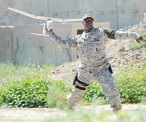
The Unmanned Aircraft System (UAS) regulatory landscape continues to evolve as the NTSB sets reporting criteria and the FAA ponders rulemaking.
The U.S. National Transportation Safety Board (NTSB) recently published a final rule establishing Treporting criteria for Unmanned
Aircraft System (UAS) related accidents.
This article offers an early look at the
course this influential independent safety
board is charting in its quest to promote
safety in the emerging UAS sector.
Although unmanned aircraft systems
(the operational combination of unmanned
aircraft and their ground control compo
nent) receive extensive and regular news
media coverage, operations in shared air-
space are still an immature and evolving
sector of aviation. This isn’t to say that
UAS are unsophisticated. On the con
trary, many high-end unmanned aircraft
are complex and highly capable, and the
vast majority of the UAS across the size
spectrum are extremely well suited to the
missions for which they’re built. However,
they also are of highly variable reliability
from system to system, and the lack of
an onboard pilot makes them uniquely
vulnerable to failures of the electronic
link through which they are controlled. So
for at least the next several years, they’re
unlikely to be operated at will in any air-
space where their lack of an equivalent
to a “see-and-avoid” capability might put
manned aircraft at risk.
Even given the above, the desired end
state for UAS operations often is referred to as “integration”: the expectation that UAS eventually will he capable of operating in a manner indistinguishable from other aircraft and will be allowed to do so on a file-and-fly basis, in all classes of airspace, and at the users’ discretion. Both regulatory and investigative entities in a number of countries are beginning to work toward this outcome. But just as different types of UAS are in different stages of readiness to make such a leap, there are many paths being taken toward it.
Differences between manned and unmanned aircraft
For readers new to UAS issues, it’s important to highlight two of the most critical differences between manned and unmanned aircraft. First, by definition, the pilot of an unmanned aircraft is physically separated from that aircraft. So there has to be an electronic connection between the two.
The “control link,” also referred to as the “uplink” in some systems, is the path through which the UAS pilot directs the unmanned aircraft’s trajectory: Currently, for all but the most sophisticated systems, the control link offers a unique source of single-point failure potential. Even for the high-end systems, safe recovery following loss of control link may require hundreds or even thousands of miles of autonomous flight for a satellite-controlled unmanned aircraft operating beyond line of sight (BLOS) to be in a position to be recaptured through an alternate line-of-sight (LOS) ground control station.
A second electronic link, which may or may not be paired with the control
link, typically is necessary to support all BLOS operations, and often is provided for purely LOS-capable UAS as well. This second link is a downlink from the aircraft to the ground that provides the principal source of the UAS pilots’ awareness of the performance and the state of their unmanned aircraft. There are no standards regarding the information contained in UAS downlinks.
They may include Global Positioning Satellite (GPS) positional data, heading, airspeed and altitude, engine health,
payload temperature, or a host of other parameters deemed necessary to safe operations. This link provides confirmation to the pilot that control commands have been properly executed by the unmanned aircraft. It’s also important to note that, for BLOS operations, air traffic control communications normally are routed through the aircraft, meaning the loss of either the uplink or downlink may result in an aircraft that unexpectedly reverts to autonomous operation while simultaneously severing all or part of the connection between pilot and controller.
The second major difference between manned and unmanned aircraft associated with the pilot’s remote location is the need to provide an alternate means of compliance with the internationally accepted concept of “see and avoid” as a means of maintaining safe separation between aircraft. Annex 2 to the Convention on International Civil Aviation states, in part,“Regardless of the type of flight plan, the pilots are responsible for avoiding collisions when in visual flight conditions, in accordance with the principle of see and avoid. “
This is mirrored in the U.S. Title 14, Code of Federal Regulations, Paragraph91.113 (b): “When weather conditions permit, regardless of whether an opera-tion is conducted under instrument flight rules or visual flight rules, vigilance shall be maintained by each person operating an aircraft so as to see and avoid other aircr°a ft. “
While the link-related issues described above relate to practical challenges arising from UAS operations, conformity with see-and-avoid obligations represents a fundamental regulatory challenge that has yet to be satisfactorily resolved. Many civil aviation authorities have ad-dressed it by restricting UAS operations to segregated airspace of various types to keep unmanned and manned aircraft from operating alongside each other. The U.S. Federal Aviation Administration (FAA) has taken the approach of authorizing most UAS operations on a case-by-case basis, requiring those wishing to fly unmanned aircraft to provide acceptable alternate means of compliance with the see-and-avoid requirement. This typically takes the form of ground-based or aerial observers charged with the duty of clearing the unmanned aircraft’s flight path, providing appropriate direction to the
pilot-in-command as necessary.
A variety of proposed alternatives to see-and-avoid requirements have been offered by eager UAS operators, including using surveillance payloads to look around for traffic, among others. But the only viable long-term hardware solution on the horizon most likely will be some kind of as yet undefined “sense and avoid” (S&A) system capable of detecting, warning of, and maneuvering the unmanned aircraft to avoid all types of conflicting aircraft, including those that do not emit any kind of electronic signal.
At this point, a reality check seems to be in order. A dedicated S&A capability probably will be expensive, from both a monetary and a payload/performance per-spective. This suggests that the smallest of the “small” UAS (a term yet to be consistently defined) is unlikely to incorporate S&A on the basis of the economic penalties it would drive. That, in turn, makes it reasonable to assume that most UAS operators will request relief from existing see-and-avoid regulations (and others applicable to manned aircraft with which they also find it difficult to comply).
What’s more, UAS at the small end of the size and weight spectrum are the most capable of supporting simple, LOS-orient-ed business models affordably. So readers should calibrate their expectations accordingly. In the near-to-mid term, most of the “unmanned aircraft” in the skies are far less likely to look like their supersized, highly capable BLOS military cousins and far more likely to look like model aircraft (perhaps indistinguishably so).
 The new NTSB UAS reporting rule
Now let’s look at the new NTSB rule on UAS accident reporting. Actually, describing the recently issued change that way is a little misleading. What the NTSB did was add a new definition for an “unmanned aircraft accident” to the existing defini-
tion of “aircraft accident” as follows: “For purposes of this part [49 CFR 830.2], the definition of ‘aircraft accident’ includes `unmanned aircraft accident, ‘ as defined herein Unmanned aircraft accident means an occurrence associated with the operation of any public or civil unmanned aircraft system that takes place between the time that the system is activated with the purpose of flight and the time that the system is deactivated at the conclusion Of its mission, in which.
(1) Any person. suffers death. or serious injury or
(2) The aircraft has a maximum gross takeoff weight of 300 pounds or greater and sustains substantial damage. “
The most notable aspects of this rule are
• It represents official acknowledgement that unmanned aircraft are in fact “aircraft,” and as such are subject to the same reporting requirements as every other aircraft involved in an accident.
• It puts UAS on a level playing field with all other aircraft regarding operators’ responsibility to the public for safe operation.
• It establishes an official structure for mandatory accident reporting for all U.S. “public-use” operators of UAS, as well as civil UAS (for now a tiny percentage of domestic UAS operations).
• It establishes a “floor” threshold, based on unmanned aircraft weight, for accident reporting.
• It creates “intent for flight” boundaries for reporting purposes that are ideally suited for UAS operations (and don’t need anybody boarding the aircraft to trigger them).
By placing manned and unmanned air craft on an equal footing for Title 49 purposes, it makes it clear that U.S. military unmanned aircraft involved in any of the types of accidents that result in NTSB jurisdiction will be subject to the same investigative authority as manned aircraft.
Why are these so important? For starters, there’s a healthy chunk of the population, both inside and outside the government, that would like nothing better than to try to treat unmanned aircraft as something less than “real” aircraft, thus not needing to conform to the regulations under which “real” aircraft operate. All kinds of requirements flow from the obligation to follow general flight rules, not to mention pilot and aircraft certification and qualification requirements.
The third bullet above-the establishment of mandatory reporting rules for “public” aircraft-is extremely important in the U.S., where there are a growing number of non-military unmanned aircraft plying the skies every day. The definition of public aircraft is fairly intricate on the printed page but reasonably straightforward in the context of present-day UAS activities. The NTSB’s specific reference to them allows a rather large umbrella to be opened over quite a few current UAS activities and also has the additional virtue of not being tied to the presence of passengers to be applicable to them.
The fourth observation above refers to the new 300-pound minimum established for reportability of unmanned aircraft accidents. This particular line in the sand, when paired with the continued applicability of the “death and serious injury” requirement, is useful for the following reasons:
(a) It ensures that the time and resources of both the Board and UAS operators won’t be wasted on hull loss accidents involving the rapidly proliferating population of small-sized unmanned aircraft.
(b) It positions the Board to keep an eye on the small but growing number of UAS platforms intended to fly for days, weeks, and even months at a time.
(c) It represents tacit acknowledgement that, while velocity is the most important variable in how hard an impact might be, something weighing 300 pounds has the potential to do some pretty impressive damage no matter how fast it’s going.
(d) The weight threshold itself is in the general range of the 150-kilogram benchmark being looked at as a starting point for UAS regulation and reportability in other countries.
The fifth bullet above refers to a regulatory gap that was plugged quite elegantly by the new language. On April 25, 2006, an RQ-1B Predator operated by the U.S. Customs and Border Protection’s Office of Air and Marine crashed near Nogales, Ariz. Although the aircraft was destroyed, there was no collateral damage or injury suffered on the ground. The NTSB dispatched a team to the site and took charge of the investigation; however, it was later pointed out that, since no one had boarded the aircraft prior to the crash, their legal basis for doing so was a bit of a stretch. Actually, this turned out to be an ideal scenario for issues like that to be surfaced; no one was hurt, there was no collateral damage, and the NTSB had an opportunity to start digging into the kinds of UAS-specific issues that are likely to appear in future unmanned aircraft accident sequences.
Finally, it’s important to have jurisdictional issues decided well in advance of a major accident, when emotions run high and there may be a desire to drive an investigation in one direction or another based on politics rather than settled policy. The United States Code sets very specific criteria for when a military accident becomes subject to civil investigation: “The National Transportation Safety Board shall investigate
(A) each accident involving civil aircraft; and (B) with the participation of appropriate military authorities, each accident involving both, military and civil aircraft (419 U.S.C. 1132). “ With a definition on the books explicitly designating unmanned aircraft as “aircraft,” this authority will be much more straightforward to apply (should the unfortunate need to do so arises).
Implications of the rule
So, what are the likely real-world changes in investigations that we’ll see based on the new rule?
1. The reporting threshold should result in newcomers to aviation manufacturing being less frequently brought into the formal investigative process than established members of the aerospace industry are. That should translate into smoother, less adversarial investigations; more often than not, the parties will understand their role and obligations.
2. The reporting threshold will tend to drive investigative resources toward accidents involving higher-value unmanned aircraft. Higher fiscal consequences naturally drive investigators and participants alike toward cooperation in determining causes and corrective actions.
3. For the near term, it’s likely that only a handful of non-military public-use UAS accidents will meet the new reportability and investigation requirements, perhaps involving assets of the Department of Homeland Security, the National Aeronautics and Space Administration, or one or two other agencies. That should result in a measured, deliberate expansion of
investigator understanding of the similarities and differences between manned and unmanned aircraft accidents, and should help the NTSB identify new skill sets and capabilities it will need to develop ahead of the inevitable wider deployment of civil UAS platforms.
For the most part, the NTSB steers clear of “incident” reporting and investigation, except where it sees a compelling need to gather data about certain types of events. So, for now at least, the NTSB most likely will concentrate on growling its ability to effectively investigate UAS-related accidents.
However; at some point, it is equally likely that it will start identifying specific issues showing up in UAS accidents that will bear closer scrutiny, in a manner similar to the current information-gathering effort on Traffic Collision Alerting System (TCAS) incidents. It’s also important to realize that, should a collision between a manned aircraft and a UAS smaller
than the 300-pound threshold occur, the same fundamental issues will need to be explored (see sidebar).
 Challenges
Now that the NTSB has taken the first steps on the road toward normalizing the investigation of UAS accidents, what needs to happen next? The following issues come immediately to mind.
First and foremost, the NTSB (and for that matter, other national investigative authorities as well) should aggressively develop the same kind of relationships with the UAS operations and manufacturing communities that they have fostered over time with manned aircraft operators and prime and major component contractors.
In this, they may have a less-than-straightforward path to follow, since the most prominent trade association for the UAS sector; the Association of Unmanned Vehicle Systems International, is principally oriented toward marketing. Industry associations such as the Aerospace Industries Association or the General Aviation Manufacturers Association, however, count among their many roles facilitation of interactions between the regulators and the regulated.
Second, now that UAS accident reporting criteria are formally a matter of federal regulation, it will be important to ensure that there is broad understanding as to when a reportable accident has occurred, and to whom the report must be submitted. This ties in with a parallel need, which both the NTSB and the FAA will need to proactively pursue to nurture and enforce a reporting culture among UAS operators that (hopefully) will come to rise above the traditional civil/military stovepipes.
Finally, there may be certain challenges associated with locating the operator, pilot, and manufacturer of a given unmanned aircraft involved in a reportable accident.
For instance, it’s not implausible to envision a scenario involving a disabling collision between a manned aircraft and a smaller unmanned aircraft (on either side
of the 300-pound threshold) in which the involvement of the latter is not recognized until an on-scene investigation is well under way.
As a practical matter, a fair amount of forensic work may be necessary just to establish the type of powerplant in use by the unmanned aircraft-probably the most likely component to survive significant impact forces-and then use that to try to track down the manufacturer and, eventually, the operator and pilot. In fairness to operators, depending on the nature of both the operation and the accident, they may know they’ve lost an aircraft, but it may not be immediately obvious that a lost link during BLOS lfight resulted in an accident many miles
from the point where contact was lost with the unmanned aircraft.
UAS Accident Investigation Considerations (2011 Edition)
For the foreseeable future, there are likely to be only a handful of NTSB investigators-in-charge with actual experience conducting a UAS accident investigation, and even fewer with
expertise specific to technical aspects of unmanned aircraft operational and materiel failures. So the following is offered to support conversations between investigators and UAS pilots and manufacturers toward the goal of increasing our collective body of knowledge on UAS issues and hazards.
The NTSB parses investigation working groups and specialties into eight categories
Operations
Structures
Power plants
Systems
Air traffic control
Weather
Human performance
Survival factors
Every one of the above may be germane to any accident investigation in which an unmanned aircraft system is either the focus of the investigation or suspected of involvement in the accident sequence. However, the knowledge and skill sets necessary to properly evaluate many aspects of UAS accidents against this investigative model need to be nurtured. Also, some “expanding-the-box” (as opposed to “out-of-the-box”) thinking should be applied in doing so.
For instance, consider the “survival factors” portion of a UAS-involved accident investigation. (Assume the microchip didn’t make it through the crash, shed a tear, and move on.) At first glance, a single-ship unmanned aircraft accident most likely wouldn’t occasion much of a require ment for survival factors investigation. However, using exotic fuels and materials, unique propulsion and electrical generation systems, and other innovative technologies has definite implications when it comes to both community emergency planning and on-scene first responder protection. Further, in the case of every midair collision between a manned and an unmanned aircraft, it will be important to assess the extent to which the unmanned aircraft was able to disrupt the survivable volume of the occupied aircraft, whether through the windscreen or the fuselage.
In every UAS-involved investigation, it is easy to envision the need for a few new tasks for some of the established working groups.
1. Operations: Establish the authority under which the unmanned aircraft system is being operated (Part 91, certificate of waiver or authorization, special airworthiness certificate in the experimental category, etc.).
2. Operations/Air Traffic/Human Performance Groups: Determine the interactions taking place at the time of the accident. Was the pilot (and observer, if required) able to perceive relevant system state information (aircraft state, ATC direction, other aircraft potentially affected)?
3. Systems: Study the system logic; consider how primary versus consequent failures might present themselves during the accident sequence (e.g., was lost link a root cause of the accident or was link lost because of other failures?).
Beyond needing to simply apply new thinking to the existing investigative disciplines listed above, serious new knowledge will need to be built in the realm of UAS-unique systems. UAS avionics are designed to meet specificneeds, but for now at least there aren’t any applicable technical specification orders (TSO) out there to help guide their development. That means there are a host of as yet unexplored questions regarding the stability of data streams between pilot and aircraft, their vulnerability to accidental (or intentional) disruption, and even the extent to which multiple unmanned aircraft can be safely operated in close proximity to each other without encountering unexpected problems.
One final point-Assessment of the radio frequency spectrum for its possible involvement in an accident sequence has rarely been required in the early days of fly-by-wire aircraft. However, putting UAS into the aviationenvironment may renew the need to do so on a regular basis and might require a new or expanded relationship between NTSB investigators and Federal Communications Commission engineers as well. The bottom line is that when it comes to UAS,to quote a time-honored aphorism, “We don’t know what we don’t know”
Summing up
With its first steps into the burgeoning ifeld of unmanned aircraft systems, the NTSB has made a commendable and necessary contribution toward normalizing some previously unresolved issues regarding how UAS accidents in the U.S. National Airspace System are to be addressed. The regulatory landscape continues to evolve, and it is welcome indeed
to see the NTSB ensuring it is actively engaged in shaping it.

 Aerial Torpedo attached to Aircraft
 General Atomics Predator RQ-1L UAV
 The rise of Unmanned Aerial Vehicles (UAVs) is driving the development on unmanned technologies in other areas. Unmanned aerial vehicles (
 Applied Technology Institute (ATI Courses) is scheduled to present the following Unmanned Aircraft Courses below.
Unmanned Air Vehicle Design Sep 24-26, 2013 Columbia, MD
Unmanned Air Vehicle Design Jan 28-30, 2014 Columbia, MD
Unmanned Aircraft System Fundamentals Jul 23-25, 2013 Columbia, MD
Unmanned Aircraft System Fundamentals Feb 25-27, 2014 Columbia, MD
This is an article that we think will be of interest to our students. It was written by Alon Unger – UVID 2013 Conference Chairman – Israel – 10.10.2013and originally appeared at
Applied Technology Institute (ATI Courses) is scheduled to present the following Unmanned Aircraft Courses below.
Unmanned Air Vehicle Design Sep 24-26, 2013 Columbia, MD
Unmanned Air Vehicle Design Jan 28-30, 2014 Columbia, MD
Unmanned Aircraft System Fundamentals Jul 23-25, 2013 Columbia, MD
Unmanned Aircraft System Fundamentals Feb 25-27, 2014 Columbia, MD
This is an article that we think will be of interest to our students. It was written by Alon Unger – UVID 2013 Conference Chairman – Israel – 10.10.2013and originally appeared at  What are the pros and cons of UAVs?
Pros include:
What are the pros and cons of UAVs?
Pros include:


 Raytheon Missile Systems is in process of designing a 13lb Small Tactical Munition to be carried by smaller unmanned aircraft like Shadow, TigerShark, Hunter and
  Northrop Grumman has come out with the Viper Strike,
  Lockheed Martin
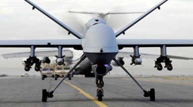
 As Aerostats are low pressure systems so if a bullet hole or other hole pops up it “doesn’t go pop like a party balloon” Browning says. Instead the helium oozes out instead of gassing out, with degradation in lift altitude occurring over time instead of instantly, he explains. “It can fly when nothing else is flying,” Browning says.
“Despite the innovative nature of the systems, aerostats, in fact, have the great advantage of payload integration and flight qualification timelines that are much shorter than that of other aircraft,” Rugg continues. “Moreover, aerostats are typically more flexible in terms of the payloads they are able to carry. Weight limitations are the paramount issue with aerostats; some aircraft have lots of available size, weight, and power (SWAP).”
Persistent threat detection
One aerostat program currently seeing action in Iraq and Afghanistan is the Army’s Persistent Threat Detection System (PTDS), which has been deployed in Iraq and Afghanistan during Operation New Dawn and Operation Enduring Freedom respectively, Browning says. PTDS is run by Rugg’s team in Huntsville produced by prime contractor Lockheed Martin.
PTDS is a tethered system, which flies like a kite with no propulsion, Browning says. The system, first deployed by the Army in 2004, is a 74,000-cubic-foot envelope full of helium and aerodynamically-shaped always pointed into the wind with fins and a tail system and is always buoyant, he adds. The maximum altitude is 5,000 feet above ground level, Browning says.
“PTDS has the unique sustained operations capability that exceeds 20 continuous days,” Rugg notes.
The system carries one or two electro-optic/infrared (EO/IR) sensor payloads as well as other communications payloads, Rugg says. The EO sensors are mostly commercial-off-the-shelf (COTS), he adds. The EO/IR payload — the MX-20 Lite from L-3 Wescam in Toronto, Ontario — is attached on the underside of the aerostat, Browning says.
The MX-20 is a turret system that uses high-definition technology, says Paul Jennison, vice president of business development for L-3 Wescam. Included in the system is digital infrared capability, a color daylight camera, mono camera for night, and lasers for range finding and illumination — that illuminates targets for ground for troops who have night vision goggles, he continues.
The only real adjustment made for the aerostat application was adding a heat exchanger for thermal management in the static air, Jennison says. “Our system also has gone through the full spectrum of MIL-STD testing for humidity, salt, fog, and dust environments,” he adds.
The PTDS communication links have extended range for deployed troops, Browning says. The sensor can provide full-motion vision to the warfighter on the ground. “Imagine the value of that to combat teams,” Browning adds.
“Based on experience in theater, a second EO/IR sensor has been added. Furthermore, due to on site weather conditions, lightning detection equipment has been added, as well as the ability to broadcast video to mobile troops carrying OSRVT (One System Remote Video Terminal),” Rugg says. “Additionally, the mooring system has been modularized to allow transport to more remote forward operating bases.”
As Aerostats are low pressure systems so if a bullet hole or other hole pops up it “doesn’t go pop like a party balloon” Browning says. Instead the helium oozes out instead of gassing out, with degradation in lift altitude occurring over time instead of instantly, he explains. “It can fly when nothing else is flying,” Browning says.
“Despite the innovative nature of the systems, aerostats, in fact, have the great advantage of payload integration and flight qualification timelines that are much shorter than that of other aircraft,” Rugg continues. “Moreover, aerostats are typically more flexible in terms of the payloads they are able to carry. Weight limitations are the paramount issue with aerostats; some aircraft have lots of available size, weight, and power (SWAP).”
Persistent threat detection
One aerostat program currently seeing action in Iraq and Afghanistan is the Army’s Persistent Threat Detection System (PTDS), which has been deployed in Iraq and Afghanistan during Operation New Dawn and Operation Enduring Freedom respectively, Browning says. PTDS is run by Rugg’s team in Huntsville produced by prime contractor Lockheed Martin.
PTDS is a tethered system, which flies like a kite with no propulsion, Browning says. The system, first deployed by the Army in 2004, is a 74,000-cubic-foot envelope full of helium and aerodynamically-shaped always pointed into the wind with fins and a tail system and is always buoyant, he adds. The maximum altitude is 5,000 feet above ground level, Browning says.
“PTDS has the unique sustained operations capability that exceeds 20 continuous days,” Rugg notes.
The system carries one or two electro-optic/infrared (EO/IR) sensor payloads as well as other communications payloads, Rugg says. The EO sensors are mostly commercial-off-the-shelf (COTS), he adds. The EO/IR payload — the MX-20 Lite from L-3 Wescam in Toronto, Ontario — is attached on the underside of the aerostat, Browning says.
The MX-20 is a turret system that uses high-definition technology, says Paul Jennison, vice president of business development for L-3 Wescam. Included in the system is digital infrared capability, a color daylight camera, mono camera for night, and lasers for range finding and illumination — that illuminates targets for ground for troops who have night vision goggles, he continues.
The only real adjustment made for the aerostat application was adding a heat exchanger for thermal management in the static air, Jennison says. “Our system also has gone through the full spectrum of MIL-STD testing for humidity, salt, fog, and dust environments,” he adds.
The PTDS communication links have extended range for deployed troops, Browning says. The sensor can provide full-motion vision to the warfighter on the ground. “Imagine the value of that to combat teams,” Browning adds.
“Based on experience in theater, a second EO/IR sensor has been added. Furthermore, due to on site weather conditions, lightning detection equipment has been added, as well as the ability to broadcast video to mobile troops carrying OSRVT (One System Remote Video Terminal),” Rugg says. “Additionally, the mooring system has been modularized to allow transport to more remote forward operating bases.”
 In addition to the aerostat, tether, and sensor payload, PTDS also has a mobile mooring platform, mission payloads, ground-control station, maintenance and officer shelter, power generators, and site-handling equipment, Browning says.
The ground-control station for an aerostat is typically on site, Rugg says. These ground-control stations are not that different from that of a UAS ground station, and “include such elements as operator consoles, workstations, tactical setup. The operating crew for a ground station is the same crew that launches and recovers the aerostat,” he adds.
Most of the electronics in the ground-control station is COTS, Rugg says. “There are two workstations for command and control of EO/IR sensors, networking equipment, UPS, aerostat flight control and monitoring computer and display as well as an Unattended Transient Acoustic MASINT Sensor (UTAMS) computer. UTAMS is an acoustic fire-detection sensor capable of locating point of impact/origin of rockets, mortars, and improvised explosive devices (IEDs).”
High-altitude airships
Lockheed Martin’s HAA — being developed for the Army — will act as a surveillance platform, telecommunications relay, or a weather observer, Browning says. Different electro-optic sensor payloads will be configured for different intelligence, surveillance, and reconnaissance (ISR) missions, he continues. Once it reaches its location it can survey a 600-mile diameter and millions of cubic miles of airspace.
In April 2008, the HAA program transferred from the Missile Defense Agency to the U.S. Army Space and Missile Defense Command, located at Huntsville, Ala. The command designing the HAA to align with the command’s mission
“The big thing to understand is that no lighter than airship has ever flown more than a few hours at more than 60,000 feet,” let alone six months, Browning says. Conventional airships have demonstrated days of endurance in the past. Current blimps for sporting events can fly for 12 plus hours, depending on conditions, he adds.
The HAA will be about 500 feet long and 150 feet high, and be airborne for six months or more at a time, Browning says. It will be launched to an area of interest and park there, he continues. It will have a sensor communication link capability for deployed troops on field to get where they want to get to, Browning adds.
“We are currently developing and demonstrating the high altitude airship concept,” Browning says. The demonstration program is called the High Altitude Long Endurance-Demonstrator (HALE-D), he adds.
HALE-D will fly this summer air at an altitude of 60,000 ft and operating for a couple weeks using small, modest payload consistent with the demonstration, Browning says.
Free flying aircraft steer and navigate from one location to another so the all-electric HALE-D will need to operate at neutral buoyancy, Browning says. Goodyear blimps are always scary, taking off with heavy with fuel, which then burns, making the aircraft more light and buoyant.
In addition to the aerostat, tether, and sensor payload, PTDS also has a mobile mooring platform, mission payloads, ground-control station, maintenance and officer shelter, power generators, and site-handling equipment, Browning says.
The ground-control station for an aerostat is typically on site, Rugg says. These ground-control stations are not that different from that of a UAS ground station, and “include such elements as operator consoles, workstations, tactical setup. The operating crew for a ground station is the same crew that launches and recovers the aerostat,” he adds.
Most of the electronics in the ground-control station is COTS, Rugg says. “There are two workstations for command and control of EO/IR sensors, networking equipment, UPS, aerostat flight control and monitoring computer and display as well as an Unattended Transient Acoustic MASINT Sensor (UTAMS) computer. UTAMS is an acoustic fire-detection sensor capable of locating point of impact/origin of rockets, mortars, and improvised explosive devices (IEDs).”
High-altitude airships
Lockheed Martin’s HAA — being developed for the Army — will act as a surveillance platform, telecommunications relay, or a weather observer, Browning says. Different electro-optic sensor payloads will be configured for different intelligence, surveillance, and reconnaissance (ISR) missions, he continues. Once it reaches its location it can survey a 600-mile diameter and millions of cubic miles of airspace.
In April 2008, the HAA program transferred from the Missile Defense Agency to the U.S. Army Space and Missile Defense Command, located at Huntsville, Ala. The command designing the HAA to align with the command’s mission
“The big thing to understand is that no lighter than airship has ever flown more than a few hours at more than 60,000 feet,” let alone six months, Browning says. Conventional airships have demonstrated days of endurance in the past. Current blimps for sporting events can fly for 12 plus hours, depending on conditions, he adds.
The HAA will be about 500 feet long and 150 feet high, and be airborne for six months or more at a time, Browning says. It will be launched to an area of interest and park there, he continues. It will have a sensor communication link capability for deployed troops on field to get where they want to get to, Browning adds.
“We are currently developing and demonstrating the high altitude airship concept,” Browning says. The demonstration program is called the High Altitude Long Endurance-Demonstrator (HALE-D), he adds.
HALE-D will fly this summer air at an altitude of 60,000 ft and operating for a couple weeks using small, modest payload consistent with the demonstration, Browning says.
Free flying aircraft steer and navigate from one location to another so the all-electric HALE-D will need to operate at neutral buoyancy, Browning says. Goodyear blimps are always scary, taking off with heavy with fuel, which then burns, making the aircraft more light and buoyant.
 One way to avoid that problem at take off is by having all-electric system that uses solar energy panels and stores the energy in batteries or rechargeable fuel cells for night flying. Propulsion units will lift the HALE-D aloft and guide its takeoff and landing during, Browning says.
The long-term operational goal — beyond the HALE-D is large with more than ton of payload onboard the HAA, Browning says. The large payload berth provides a lot of flexibility in payload design and capability, he continues. “It can really open the imagination of the sensor designer,” Browning adds.
The sensor technology is already available on a lot of aircraft, Browning says. However as with some existing airborne and spaceborne platforms the biggest challenge is reliability. Once the system is launched it won’t be brought down for several months, so you need sensors that last in tough environments.
The HALE-D sensors include a Thales MMAR modem, an L-3 Communications mini CDL, and an electro-optical system from ITT Geospatial Systems in Rochester, N.Y., Browning says.
ITT provided a long focal-length panchromatic electro-optical (EO) camera with GPS/Inertial Navigation System (INS) and pointing capability for the HALE-D program, says David A. Parkes, senior business development manager at ITT Geospatial Systems.
“An unmanned high-altitude platform does bring unique challenges in designing EO solutions,” Parkes says. “First, it’s very high flight altitudes bring very cold temperatures as low as -50 degrees Celsius and little air, which makes it challenging to both start up and maintaining proper electronics temperatures. It is more space-like than airborne. The ascent to these high altitudes also drives the need for all components to be able to outgas, so they are not damaged (e.g. optical lens). The second challenge is that current payload capacities for high altitude platforms are relatively small, which drives the need for very light weight and low power payloads.”
“The objectives and funding of this EO system were primarily for functional demonstration on this exciting high-altitude platform,” Parkes continues. “This drove a highly COTS-based solution. Future high-altitude EO systems will require designs that provide higher performance and high reliability that will leverage space systems designs without space system costs.”
Long-endurance airships
Northrop Grumman’s LEMV program completed its critical design review (CDR) six months after signing the agreement with the U.S. Army. Under that agreement the company will build three airships with 21-day persistent ISR capability, according to a Northrop Grumman release. Northrop Grumman officials declined to be interviewed for this story.
One way to avoid that problem at take off is by having all-electric system that uses solar energy panels and stores the energy in batteries or rechargeable fuel cells for night flying. Propulsion units will lift the HALE-D aloft and guide its takeoff and landing during, Browning says.
The long-term operational goal — beyond the HALE-D is large with more than ton of payload onboard the HAA, Browning says. The large payload berth provides a lot of flexibility in payload design and capability, he continues. “It can really open the imagination of the sensor designer,” Browning adds.
The sensor technology is already available on a lot of aircraft, Browning says. However as with some existing airborne and spaceborne platforms the biggest challenge is reliability. Once the system is launched it won’t be brought down for several months, so you need sensors that last in tough environments.
The HALE-D sensors include a Thales MMAR modem, an L-3 Communications mini CDL, and an electro-optical system from ITT Geospatial Systems in Rochester, N.Y., Browning says.
ITT provided a long focal-length panchromatic electro-optical (EO) camera with GPS/Inertial Navigation System (INS) and pointing capability for the HALE-D program, says David A. Parkes, senior business development manager at ITT Geospatial Systems.
“An unmanned high-altitude platform does bring unique challenges in designing EO solutions,” Parkes says. “First, it’s very high flight altitudes bring very cold temperatures as low as -50 degrees Celsius and little air, which makes it challenging to both start up and maintaining proper electronics temperatures. It is more space-like than airborne. The ascent to these high altitudes also drives the need for all components to be able to outgas, so they are not damaged (e.g. optical lens). The second challenge is that current payload capacities for high altitude platforms are relatively small, which drives the need for very light weight and low power payloads.”
“The objectives and funding of this EO system were primarily for functional demonstration on this exciting high-altitude platform,” Parkes continues. “This drove a highly COTS-based solution. Future high-altitude EO systems will require designs that provide higher performance and high reliability that will leverage space systems designs without space system costs.”
Long-endurance airships
Northrop Grumman’s LEMV program completed its critical design review (CDR) six months after signing the agreement with the U.S. Army. Under that agreement the company will build three airships with 21-day persistent ISR capability, according to a Northrop Grumman release. Northrop Grumman officials declined to be interviewed for this story.
 “The power of the LEMV system is that its persistent surveillance capability is built around Northrop Grumman’s open architecture design, which provides plug-and-play payload capability to the warfighter and room for mission growth,” says Alan Metzger, Northrop Grumman vice president and integrated program team leader of LEMV and airship programs in the company release. “The system rapidly accommodates next-generation sensors as emerging field requirements dictate and will provide increased operational utility to battlefield commanders. Today, our system readily integrates into the Army’s existing Universal Ground Control Station and Deployable Common Ground System command centers and ground troops in forward operating bases.
“While LEMV is longer than a football field and taller than a seven-story building, it utilizes approximately 3,500 gallons of fuel for the air vehicle to remain aloft for a 21-day period of service, that’s approximately $11,000 at commercial prices.
“We’ll have hull inflation in the spring and first flight of the airship test article by mid-to-late summer,” he says. Upon completion of the development ground and flight testing phase, we expect to transition to a government facility and conduct our final acceptance long endurance flight just before year’s end. In early 2012, LEMV will participate in an Army Joint Military Utility Assessment in an operational environment.”
Northrop Grumman’s industry team includes Hybrid Air Vehicles, Ltd. of the England, Warwick Mills, ILC Dover, AAI Corp., SAIC in McLean, Va., and a team of organizations from 18 U.S. states and three countries. In addition to leading the program, Northrop Grumman leads the system integration, and flight and ground control operations for the unmanned vehicle.
“The power of the LEMV system is that its persistent surveillance capability is built around Northrop Grumman’s open architecture design, which provides plug-and-play payload capability to the warfighter and room for mission growth,” says Alan Metzger, Northrop Grumman vice president and integrated program team leader of LEMV and airship programs in the company release. “The system rapidly accommodates next-generation sensors as emerging field requirements dictate and will provide increased operational utility to battlefield commanders. Today, our system readily integrates into the Army’s existing Universal Ground Control Station and Deployable Common Ground System command centers and ground troops in forward operating bases.
“While LEMV is longer than a football field and taller than a seven-story building, it utilizes approximately 3,500 gallons of fuel for the air vehicle to remain aloft for a 21-day period of service, that’s approximately $11,000 at commercial prices.
“We’ll have hull inflation in the spring and first flight of the airship test article by mid-to-late summer,” he says. Upon completion of the development ground and flight testing phase, we expect to transition to a government facility and conduct our final acceptance long endurance flight just before year’s end. In early 2012, LEMV will participate in an Army Joint Military Utility Assessment in an operational environment.”
Northrop Grumman’s industry team includes Hybrid Air Vehicles, Ltd. of the England, Warwick Mills, ILC Dover, AAI Corp., SAIC in McLean, Va., and a team of organizations from 18 U.S. states and three countries. In addition to leading the program, Northrop Grumman leads the system integration, and flight and ground control operations for the unmanned vehicle.