“Houston, we have a problem.” “Say again, Apollo 13.” “We have a problem.” It was a problem all right! Seconds before, a violent explosion had ripped through the Apollo Service Module, knocking out two of its three fuel cells and dumping the astronauts’ precious oxygen supplies into black space. At first they managed to remain […]
“Houston, we have a problem.”
“Say again, Apollo 13.”
“We have a problem.”
It was a problem all right! Seconds before, a violent explosion had ripped through the Apollo Service Module, knocking out two of its three fuel cells and dumping the astronauts’ precious oxygen supplies into black space. At first they managed to remain fairly calm, but as their crippled spacecraft hurtled on toward the moon, a fresh crisis suddenly unfolded: The lithium hydroxide canisters in the LEM (Lunar Excursion Module) and the Service Module turned out to be noninterchangeable, and as a result, the air the astronauts were breathing was rapidly becoming polluted. Fortunately, they were able to patch together a workable connection to the canisters in the Service Module, thus making them usable in their overcrowded “lifeboat” LEM. During the next few years other astronauts successfully achieved a number of other spectacular spaceborne repairs, thus proving that astronauts were definitely not merely along for the ride of “Spam in a can” as a cynical journalist once wryly observed. When the micrometeoroid shield was ripped off the main body of the Skylab, for instance, the astronauts erected a big cooling parasol to shield themselves from the burning rays of the sun. On the next mission, astronauts Jack R. Lousma and Owen K. Garriott remodeled the Skylab’s parasol sunshade by erecting two 55-foot metal poles to form a large A-frame tent over their freshly occupied home in space. Other Skylab astronauts repaired an ailing battery, retrieved exposed film from the Apollo telescope mount, and removed and replaced several gyroscopes used in stabilizing their wobbling craft. These complicated tasks were all performed in full space suits outside the protective envelope of the Skylab modules.
The retrieval and redeployment of the Solar Max satellite — which was filmed with IMAX cameras operated by other space shuttle astronauts — provides another powerful illustration of the skill and dexterity of humans in space.Ì Space-age robots have also performed in a similarly impressive manner. For instance, when the television camera mounted on the elbow of the shuttle’s 50-foot robot arm sent back pictures of a big chunk of ice growing on the outside of the waste-water vent on the shuttle orbiter, the Canadian robot arm helped the astronauts execute a clever solution. Rather than risk possible damage to the shuttle’s delicate heat shield, should chunks of the ice break loose during reentry the astronauts were instructed to use the robot arm like a big, heavy trip hammer to knock the ice loose.
On another mission, the robot arm was ready to release the Earth Radiation Budget Satellite into the blackness of space. Unfortunately, during deployment, its solar arrays got stuck in an awkward position so the astronauts used the robot arm to shake the satellite vigorously. Then they held it up to the warming rays of the sun so its solar array could unfold.
SCHEMES FOR ENHANCING THE SATURN V MOON ROCKET’S TRANSLUNAR PAYLOAD CAPABILITY INTRODUCTION When I was a teenager struggling to master algebra, geometry, and trigonometry in a tiny little high school in the Bluegrass region of Kentucky, I loved doing mathematical derivations. Those squiggly little math symbols arranged in such neat geometrical patterns on the printed […]
SCHEMES FOR ENHANCING THE SATURN V MOON ROCKET’S TRANSLUNAR PAYLOAD CAPABILITY
INTRODUCTION
When I was a teenager struggling to master algebra, geometry, and trigonometry in a tiny little high school in the Bluegrass region of Kentucky, I loved doing mathematical derivations. Those squiggly little math symbols arranged in such neat geometrical patterns on the printed pages held endless fascination for me. But never in my wildest dreams, could I ever have imagined that I might someday be stringing together long, complicated mathematical derivations that would allow enthusiastic American astronauts to hop around on the surface of the moon like gigantic kangaroos.
Nor could I have imagined that someday my Technicolor derivations would end up saving more money than a typical American production line worker could earn in a thousand lifetimes of fruitful labor.
I was born and raised in a very poor family. My brother once characterized us as “gravel driveway poor”. At age 18 I had never eaten in a restaurant. I had never stayed in a hotel. I had never visited a museum. But, somehow, I managed to work my way through Eastern Kentucky University, one of the most inexpensive colleges in the state. I graduated in 1959 with a major in mathematics and physics eighteen months after the Russians hurled their first Sputnik into outer space. That next summer I accepted a position with Douglas Aircraft in Santa Monica, California, and what a wonderful position that turned out to be! At Douglas Aircraft we were launching one Thor booster rocket into outer space every other week.
In 1961 after I earned my Master’s degree in mathematics at the University of Kentucky, I was recruited to work on Project Apollo. And I am convinced that anyone who ever worked on the Apollo Project would tell you that Apollo was the pinnacle of the rocket maker’s art.
At age 18 I had never eaten in a restaurant. I had never stayed in a hotel. I had never visited a museum. But somehow, by some miracle, six year later at age 24, I was getting up every day and going to work and helping to put American astronauts on the moon!
WHAT IS A MATHEMATICAL DERIVATION?
A mathematical derivation is a series of mathematical and logical steps that starts with something that every expert can agree is true and ends up with a useful conclusion, usually one or more mathematical equations amenable to an easy solution.
Hollywood’s version of a mathematical derivation is almost always carried out on big, long blackboards with no words anywhere. But I did all of my derivations with words and in Technicolor – using colored pencils and colored marking pens – on big, oversized quad pads four times as big as a standard sheet of paper. One day when my daughter, Donna, was about five years old, she wandered into my den and watched me struggling over a particularly difficult derivation. “This is embarrassing,” she maintained, “My father colors better than I do.”
Most of the derivations my friend, Bob Africano, and I put together in those exciting days centered around our struggles to enhance the performance capabilities of the mighty Saturn V moon rocket. The Saturn V was 365 feet tall. It weighed six million pounds. It generated 7.5 million pounds of thrust and, over nine pulse-pounding Apollo missions, it carried 24 American astronauts into the vicinity of the moon. Twelve of those astronauts walked on the moon’s surface. The other twelve circled around it without landing.
Even the simplest mathematical derivation can be difficult, frustrating work and, over the years, we put together hundreds of pages of them. For ten years, and more, we worked 48 to 60 hours per week. We were well paid and treated extremely well and we loved what we were doing for a living. But we were often teetering on the ragged edge of exhaustion. One night at a party I observed that doing mathematical derivations for a living was like “digging ditches with your brain!”
In my career I followed the dictum of the British mathematician Bertram Russell. “When you’re young and vigorous, you do mathematics,” he once wrote. “In middle age you do philosophy. And in your dotage, you write novels.” Sad to say, I just finished my first novel! It is intended to become a Hollywood motion picture entitled the 51st State. So this white paper is being composed while I am in my dotage.
THOSE CHALLENGING DAYS AT ROCKWELL INTERNATIONAL
I joined the staff of Rockwell International at Downey, California, in 1964. Each morning I would jaywalk across Clark Avenue to get to work in Building 4. I was assigned to a systems engineering group consisting of about 20 engineers and support personnel led by supervisor, Paul Hayes. Paul was proficient in several branches of mathematics and he carefully checked and rechecked the mathematical derivations we were publishing in internal letters, company reports, and in the technical papers we were presenting at big conventions around the country and in a few foreign countries, too.
Most of our time and effort was devoted to figuring out how to operate the S-II stage (the second stage of the Saturn V moon rocket) with maximum practical efficiency. We didn’t make any modifications to the hardware; the hardware was already built. Instead, we used the mathematics and the physics we had learned in school, as effectively as possible, to maximize the payload of the mighty Saturn V.
Over about ten years on the project, Africano and I – and various others – developed hundreds of pages of useful mathematical derivations. Various other engineers scattered around the country were also trying to figure out how to send more payload to the moon. Joe Jackson, Scott Perrine, and Wayne Deaton at NASA Huntsville, for instance, and Carol Powers and Chuck Leer and their colleagues at TRW in Redondo Beach, California all made significant contributions to this important work.
During those early days we were taking mathematics and physics courses at UCLA and UCI (The University of California at Irvine) and teaching courses of our own at the California Museum of Science and Industry, Cerritos College, USC, and at Rockwell International in Downey and Seal Beach, California.
Our supervisor, Paul Hayes, showed remarkable patience and leadership when the mathematics (or my own stubbornness) led me down blind alleys. On one occasion, for example, I spent about 3 weeks formulating a more precise family of guidance equations for our six-degree-of-freedom trajectory program. Unfortunately, when those equations were finally finished, checked, and programmed the rocket’s trajectory hardly changed at all. I was rather apologetic, but Paul had an entirely different way of looking at what we were doing for a living. “It’s OK” he told me, softly. “Try something else.”
He exhibited the same magnanimous attitude when I insisted on using disk storage to replace the nine magnetic tapes we were using for “scratch-pad” memory. We burned up two weeks or so reprogramming the routines in an attempt to save computer time (which in those days cost $700 per hour!). Unfortunately, as our programmer, Louise Henderson, had predicted, no computer-time saving at all resulted from this tedious and time-consuming effort.
Paul Hayes realized that we could not make major breakthroughs in the difficult fields of applied mathematics, orbital mechanics and systems engineering unless we were willing to risk humiliating failures along the way! Fortunately, we did, eventually, perfect four powerful mathematical algorithms that saved an amazing amount of money for the Apollo program. These algorithms, which required no hardware changes and cost virtually nothing to implement, involved at least eight difficult branches of advanced mathematics.
In 1969 Bob Africano and I summarized the salient characteristics of these four mathematical algorithms in a technical paper we presented at a meeting of the American Institute of Aeronautics and Astronautics (AIAA) at the Air Force Academy in Colorado Spring, Colorado. It was entitled “Schemes for Enhancing the Performance Capabilities of the Saturn V Moon Rocket.” In that paper we showed how those four mathematical algorithms increased the translunar payload-carrying capabilities of the Saturn V by about 4700 pounds. Measured in 1969 dollars, each pound of that payload was worth $2000, or about 5 times its weight in 24-karat gold. NASA ended up flying nine manned missions around the moon. Consequently, those mathematical algorithms, liberally laced with physics and astrodynamics, ended up saving the American space program $2.5 billion valued in accordance with today’s cost of $1140 for each pound of gold.
In the paragraphs to follow, I will attempt to summarize the methods we used to achieve those important payload gains and to describe the mathematical techniques we employed in accentuating the rocket’s performance.
PROPELLANT UTILIZATION SYSTEMS
A large liquid-fueled rocket usually includes two separate tanks, one containing the fuel and the other containing the oxidizer. These two fluids are pumped or forced under pressure into the combustion chamber immediately above the exhaust nozzle, where burning of the propellants takes place.
If we would load 1000 rockets with the required quantities of fuel and oxidizer, then fly them to their destination orbits, we could expect – due to random statistical variations along the way – to have a small amount of fuel left over on 500 of those flights and a small amount of oxidizer left over on the other 500. Neither the fuel nor the oxidizer can be burned by itself because burning requires a mixture of the two fluids.
In order to minimize the average weight of the fuel and oxidizer residuals on the upper stages of the Saturn V rocket, the designers had introduced so-called Propellant Utilization Systems. A Propellant Utilization System employs sensors to monitor the quantities of fuel and oxidizer remaining throughout the flight. It then makes automatic real-time adjustments in the burning-mixture-ratio to achieve nearly simultaneous depletion of the two fluids when the rocket burns out.
For the Saturn V, the necessary measurements were made with capacitance probes running along the length of the fuel tank and the oxidizer tank. A capacitance probe is a slender rod encased within a hollow cylinder. Openings at the bottom of the hollow cylinder allow the fluid level on the inside of it to duplicate its level on the outside.
As the fluid level inside the cylinder decreases, the electrical capacitance of the circuit changes to provide a direct measure of the amount of fluid remaining in the tank. These continuous fluid-level measurements are then used in making small real-time adjustments in the rocket’s burning-mixture-ratio to achieve nearly simultaneous depletion of the two propulsive fluids.
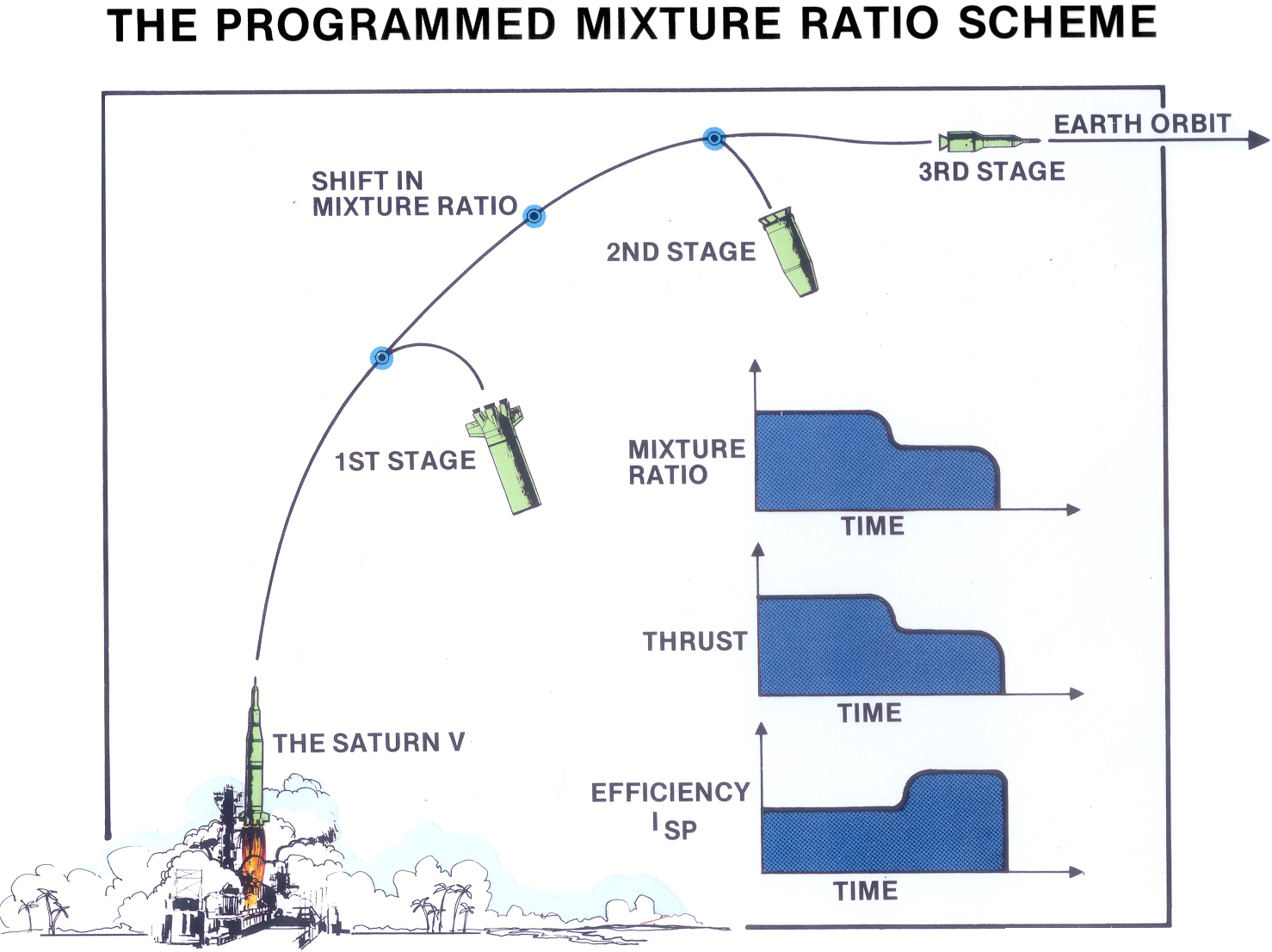
THE PROGRAMMED MIXTURE RATIO SCHEME
The Propellant Utilization System on the S-II stage increased the performance of the booster by an extra 1400 `pounds of payload headed toward the moon. Unfortunately, modeling the behavior of the propellant utilization systems in flight created a complicated problem for the mission planning engineers. When we were simulating the translunar trajectories and the corresponding payload capabilities for the Saturn V, we found that, if we ran two successive simulations with identical inputs, each simulation would yield a slightly different payload at burnout.
These rather unexpected payload variations came about because the computer program’s subroutines automatically simulated slightly different statistical variations in the Propellant Utilization System during each flight. In order to circumvent this difficulty, we did what engineers almost always do – we called a meeting. And at that meeting we brainstormed various techniques for making those pesky payload variations go away. Fortunately, no one in attendance that day was able to come up with a workable solution.
Sitting in the back of the room was long, lanky propulsion specialist named Bud Brux. who said almost nothing during the meeting. But, when Bud Brux got back to his office, he began thinking about the problem we had encountered. “Hey, wait a minute!” he thought, “The reason we build a rocket is to put payload into space. If something is causing that payload to vary, maybe we should try to accentuate the effect, rather than trying to make it go away.”
Bud Brux then wrote us a simple, two-page internal letter suggesting that we vary the mixture ratio as much as we possible in a few of our computer simulations to see if we could produce important performance gains. We were not particularly excited by the letter he wrote; we received lots of internal letters in those days. But, when those first few trajectory simulations came back from the computer, our excitement shot up by a decibel or two. On the best of those simulations, the Saturn V moon rocket was able to carry nearly 2700 extra pounds of payload to the moon, each pound of which was worth $2000 – or five times its weight in 24-karat gold.
The five J-2 engines mounted on the second stage of the Saturn V moon rocket were originally designed to burn their propellants at a constant steady-state mixture ration of 5 to 1 (5 pounds of liquid oxygen for every pound of liquid hydrogen). By working our way through the proper mathematical derivations, however, we showed that, if we started out with a mixture ratio of 5.5 to1, then abruptly shifted to 4.5 to 1, the booster rocket could hurl an extra 2700 pounds onto its translunar trajectory. This so-called Programmed Mixture Ratio Scheme required no hardware changes. We merely opened 5 existing valves a little wider in mid flight.
The sketches in Figure 1 highlight some of the salient characteristics of the Programmed Mixture Ratio Scheme as applied to the second stage of the Saturn V moon rocket. Early in that rocket’s flight, we set the burning-mixture ratio at 5.5 to 1 (5.5 pounds of oxidizer for every pound of fuel). But 70 percent of the way through the burn we abruptly shifted that mixture ratio to a lower value of 4.5 to 1.
As the small graphs in Figure 1 indicate, this shift in the mixture ratio provided the rocket with high thrust early in its flight at a slightly lower specific impulse.* Then, following the Programmed Mixture Ratio shift, it had a lower thrust, but a higher specific impulse.
After studying the computer simulations and putting together several dozen pages of mathematical derivations, we concluded that the abrupt Programmed Mixture Ratio shift caused the rocket to leave more of its exhaust molecules lower and slower as it flew toward the moon. This, in turn, put less energy into the exhaust molecules and correspondingly more energy into the payload. The resulting performance gains are not insignificant. On each of the missions we flew to the moon, the Programmed Mixture Ratio Scheme allowed us to send 2700 extra pound of payload onto the rocket’s translunar trajectory!
When the last Apollo mission had been completed, I wrote an internal letter highlighting the clever insights and the important engineering accomplishments of our illustrious colleague. “If Bud Brux had sent us a note telling us where five solid gold Cadillacs were buried in the company parking lot,” I concluded, “it would not have been worth as much as the note he actually wrote!”
In my view, mathematical derivations that involve moving objects such as a booster rocket or an orbiting satellite can be surprisingly interesting. Those that center around objects that move along optimal trajectories are even more interesting. But the most interesting derivations of all, involve objects that move along optimal trajectories that are experiencing random statistical variations. The work that we did on optimal fuel biasing fell into the third category with random statistical variations superimposed on a booster rocket that was moving along an optimal trajectory.
__________________ * The specific impulse of a rocket propellant combination provides us with a measure of the efficiency of the rocket. It equals the number of seconds a pound of the propellant can produce a pound of thrust.
OPTIMAL FUEL BIASING
If we load 1000 identical hydrogen-oxygen rockets with the desired amounts of fuel and oxidizer in the proper ratio and then fly all 1000 of them into earth orbit along 1000 statistically varying trajectories, approximately 500 of them will end up with fuel residuals at burnout, and the other 500 will end up with oxidizer residuals.
Moreover, on the average, the 500 oxidizer residuals will turn out to be approximately five times heavier than the 500 fuel residuals because a typical hydrogen-oxygen rocket carries five pounds of oxidizer for every pound of fuel. Consequently, if we would add a little extra fuel to each of those 1000 rockets before lift-off, that extra fuel would reduce the statistical frequency of the heavier oxidizer residuals. Moreover, the few remaining oxidizer residuals that do occur will be lighter because of the fuel bias we have added.
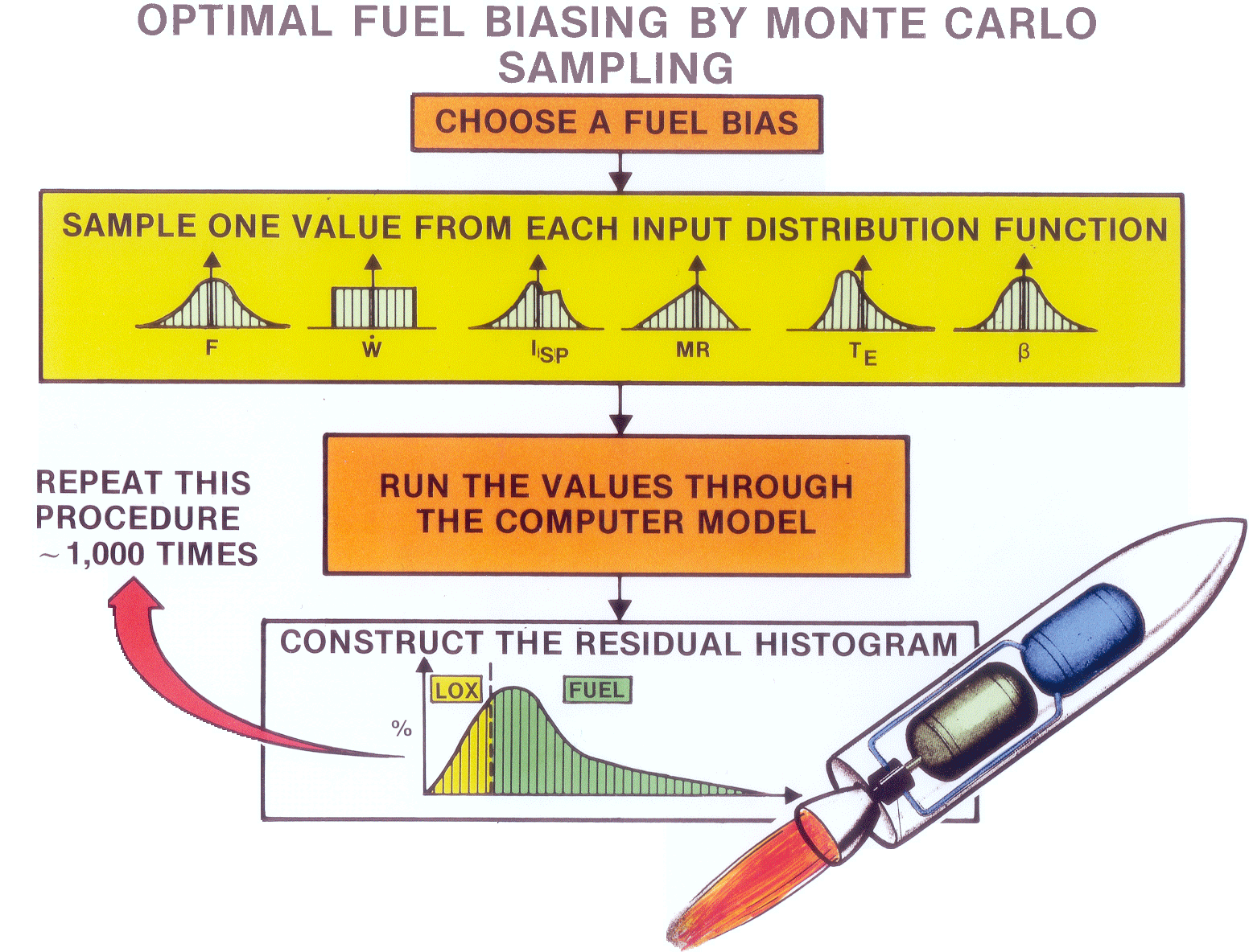
In practice, however, figuring out precisely how much extra fuel to add to achieve optimal mission performance turned out to be a difficult and expensive problem in statistics. Our first approach toward determining the optimal fuel bias is flowcharted in Figure 3. In each of our simulations we command the computer to choose a fuel bias and then sample a series of statistically varying values having to do with the variation of the rocket’s thrust, its flow rate, its specific impulse, its mixture ratio, and so on. The computer then substituted each of these statistical values into our optimal trajectory simulation program, and at burnout, it recorded the type of residual (fuel or oxidizer) and its corresponding weight.
This so-called “Monte Carlo” simulation procedure was repeated hundreds or thousands of times to allow the computer to construct an accurate statistical “snapshot” similar to the one sketched at the bottom of Figure 2. Repetitions of those computerized procedures executed with different fuel-bias levels allowed us to determine the fuel bias that provided the optimum rocket performance.
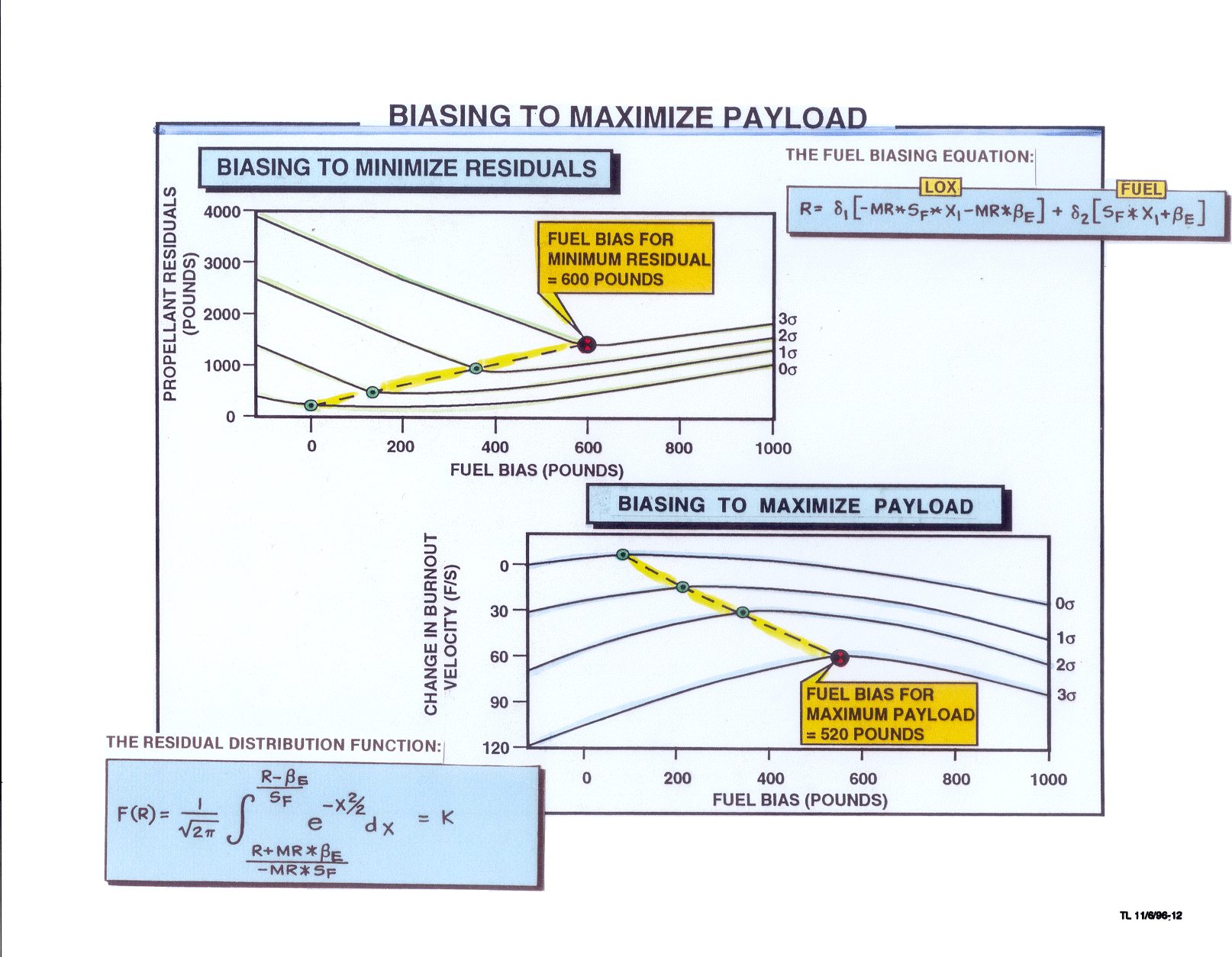
This technique worked as advertised, but it turned out to be extremely costly, in the days when computer simulation time was so incredibly expensive. However, after several hours of mind-bending mathematical manipulations, I managed to reduce the essence of the optimization problem we faced to a single mathematical equation. It was an integral equation from calculus with variable limits of integration based on the normal distribution functions from the statistics courses I had been attending at UCLA.
In the 1960’s this Monte Carlo sampling procedure provided our analysis team with a simple and convenient method for finding the optimum amount of fuel bias to add to the S-II Stage to minimize its “3-sigma” fuel and oxidizer residuals. Although this procedure was conceptually simple and easy to implement, finding the optimum fuel bias turned out to be extremely costly in an era when a rather primitive IBM 7094 computer rented for $700 per hour. On a typical Apollo mission we were burning though $95,000 worth of computer time to find the optimum bias level. Practical alternatives were mathematically elusive, but eventually we developed a far more economical approach based on Leibniz’ rule for the differentiation of integral equations.
That equation, though simple in appearance, could not be integrated to get a simple answer in closed form. Fortunately, that summer I had been studying a powerful branch of mathematics called the calculus of variations pioneered, in part by my hero, Isaac Newton.
Isaac Newton, Christmas present to the world, was born on December 25, 1642. In that era, if a talented mathematician would solve a difficult mathematical problem, he would sometimes pose the problem to various other famous mathematicians before publishing the solution.
Such a problem had been posed by the Bernoulli brothers, two famous Swiss mathematicians. It centered around the optimal shape for a wire on which a small bead would slide in minimum time from one point to another under the influence of gravity. The Bernoulli brothers had posed this problem to Newton’s rival Gottfried Wilhelm von Leibniz who had not been able to solve it within the three months they had allotted. So he requested six more months in which to devise a solution. The Bernoulli brothers granted his request, but they also included Newton in their new challenge.*
That day Newton came home from a tiring day of working in the British mint, read his mail, and began working on the problem. By the time he fell into bed that night, he had devised a brilliant solution which he published anonymously. On seeing the solution, John Bernoulli is said to have remarked, “I recognize the lion by his paw!” In his view, no other living mathematician was clever enough to have devised the published solution.
As luck would have it, one of the key relationships in the calculus of variations turns out to be Leibniz’s rule for the differentiation of integral equations with variable limits of integration! I had never seen Leibniz’s rule applied to a statistics problem, but it turned out to be the key to obtaining the solution to the optimal fuel biasing problem we were
______________ * Egged on by British and continental mathematicians and scientists, Newton and Leibniz engaged in a lifetime rivalry. At one point, however, Leibniz paid Isaac Newton a supreme compliment: “Of all the mathematics developed up until the time of Isaac Newton,” he wrote, “Newton’s was, by far, the better half.” seeking. By using Leibniz’s rule, some well-known identities from statistics, a back-handed interpretation of “standard deviation”, and a closed-form version of the rocket equation as derived in 1903 by that lonely Russian school teacher, Konstantin Tsioikovsky, I finally managed to develop a simple closed-form solution to our optimal fuel-biasing problem!
For Rockwell International’s hydrogen-fueled S-II stage, our Monte Carlo approach had typically required 10,000 computer simulations executed at a total cost of $95,000 per flight. The new closed-form approach, based on Leibniz’s rule, required only 13 computer simulations at a cost of around $3000.
My supervisor, Paul Hayes, again demonstrated his leadership when he secretly submitted a company suggestion in my name indicating that I had managed to develop a derivation that saved the Saturn S-II Program over $700,000 based on nine manned missions flown into the vicinity of the moon. Paul was sorely disappointed when the reply came back from the suggestion group: No award was to be forthcoming because, as they pointed out: “That’s what he does for a living.”
The parametric curves at the bottom of Figure 3, which were constructed using the closed-form equations I derived, were used to determine the optimum fuel-bias level. For a typical Apollo mission, the optimum amount of fuel to add turned out to be about 600 pounds, assuming that we wanted the smallest residual propellant remaining at the “3 sigma” probability level (99.87 percent).
Bob Africano and I later published a technical paper in which we discussed the fact that biasing to minimize residuals is not the same as biasing to maximize payload. We reasoned that these two bias levels must be slightly different because, when we add fuel bias to minimize the residuals, the fuel bias itself represents a dead weight that the rocket must carry into space. However, we soon discovered that no matter how many times we manipulated the relevant mathematical symbols, we could not discover the desired relationship. Several years later, however, John Wolfe, a superb space shuttle engineer, read our paper and figured out how to bias to maximize payload. John Wolfe was such a generous soul, he even claimed, in print, that Bob Africano and I had solved the problem on our own. Actually, all we had done was to formulate the problem. John Wolfe, himself, provided the solution!
A clever mathematical algorithm based on Leibniz’ rule for the differentiation of integral equations with variable limits of integration allowed us to find the fuel bias that would minimize the “3-sigma” fuel and oxidizer residuals remaining at burnout of the Saturn S-II stage. This new approach saved $92,000 per flight while achieving essentially identical results. Later a highly creative space shuttle engineer, John Wolfe, figured out how to modify our procedure to maximize the payload of the reusable space shuttle.
It was not a difficult derivation; we understood it immediately. But finding it did required a rather unusual mathematical approach that had eluded us throughout several dozen oversized pages of Technicolor derivations.
POSTFLIGHT TRAJECTORY RECONSTRUCTION
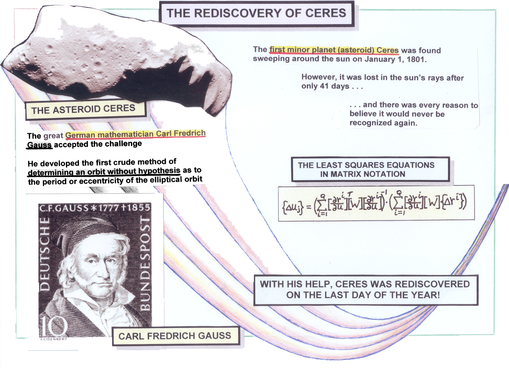
On January 1, 1801, the first minor planet, Ceres, was spotted by alert telescope-equipped astronomers as it hooked around the sun. Ceres, which we now call an asteroid, was a new type of object never seen by anyone on Earth up until that time. Unfortunately, after Ceres had been in view for only 41 days, it traveled so close to the harsh rays of the sun it was lost from view. The astronomers who were tracking it were afraid that it might never be found again.
However, as Figure 4 indicates, the famous German mathematician Carl Frederich Gauss accepted the challenge of trying to reconstruct the trajectory of Ceres from the small number of closely spaced astronomical observations available to him. Under his brilliant direction, Ceres was located again on the other side of the Sun on the last day of 1801, almost exactly one year after it had first been discovered.*
More than 160 years later in 1962, we adapted the mathematical methods Gauss had used in reconstructing the orbit of Ceres to determine the performance of the Saturn V moon rocket on a typical mission. When we were executing a preflight trajectory simulation, we would feed the thrust and flow-rate profiles into the program together with the initial weight of the vehicle, its guidance angle histories, and the like, and then we would simulate the resulting trajectory of the rocket. In a postflight trajectory simulation, we did exactly the opposite. We would feed the program the trajectory of the
______________ * When Gauss was in elementary school in Germany, one of his teachers asked her students to “add up all the values of the 100 integers ranging from 1 to 100.” While his classmates were struggling to obtain the solution, the young Gauss wrote down the answer immediately. He had noticed that there were 50 pairs of numbers – each of which totaled 101; they were 1 + 100, 99 + 2, 98 + 3 . . and so the desired total was equal to 50 (101) = 5050. rocket – as ascertained by the tracking and telemetry measurements – and then we would use the computer to determine the thrust and flow-rate profiles and the guidance angles the booster must have had in order to have traveled along the observed trajectory.
In 1801 the brilliant German mathematician Carl Frederich Gauss devised a marvelously efficient mathematical algorithm that allowed the astronomers of his day to relocate the asteroid Ceres – a tiny pinpoint of light – as it emerged from the harsh rays of the sun. Approximately 160 years later our analysis team adapted this so-called iterative least squares hunting procedure to help us reconstruct the postflight trajectories of the various stages of the mighty Saturn V. Over time these mathematical techniques increased the rocket’s translunar payload by 800 pounds.
Years later in a television interview on the ABC television network, my host asked me what a trajectory expert does for a living. “We predict where the rocket will go before the flight,” I replied. “Then, after the flight, we try to explain why it didn’t go there.”
Those of us who worked as trajectory experts on the Saturn V moon rocket developed one of the most sophisticated postflight trajectory reconstruction programs ever formulated up until that time. It included more than 10,000 lines of computer code (five boxes of IBM cards!) and it required 300 inputs per simulation, all of which had to be correct if the program was to produce the desired results. Unfortunately, 75 percent of our simulations blew up due to incorrect inputs. A small percent of the others blew up because we made various mistakes when we made modifications to the program.
In a typical postflight reconstruction, we simulated a 400-second segment of the rocket’s trajectory which required about 2.5 hours of computer time on an IBM 7094 mainframe computer at a cost of about $700 per hour. Our six-degree-of-freedom iterative least squares hunting procedure was structured so we could, on any given simulation, choose up to nine independent variables, such as vehicle attitude, slant range, inertial velocity, and the like. We could choose up to nine dependent variables, such as the rocket’s thrust profile, flow-rate history, the initial weight of the rocket, and so on.
We initially formulated the six-degree-of-freedom trajectory program so that all the search variables were added to or multiplied by the prime variables (e.g .the thrust profile or the weight history of the rocket stage). Later we figured out how to include additive or multiplicative polynomials with variable coefficients that were determined automatically by the computer. We also figured out how to “segment” (chop up) the relevant polynomials with automatic computer-based determination of the polynomial coefficients in each of the segments being determined independently. The independent variables were measured during the flight with tracking devices located on the ground and telemetry devices carried onboard the rocket. On a typical Saturn V trajectory reconstruction, the computer calculated about 30 partial derivatives at each of the 400 time points spaced one second apart. The resulting partial derivatives – around 12,000 of them – were arranged sequentially in a special matrix format and recorded on as many as nine magnetic tapes.
On a typical Apollo flight, the average deviation between the predicted preflight trajectory and the actual postflight trajectory was about one mile. However, after 2.5 hours of simulation time on an IBM 7094 computer, the iterative least squares hunting procedure typically reduced this average error to only about one foot!
After running a series of computer simulations of this type, we were able to get a much better handle on the statistical variations in the dependent variables such as the rocket’s thrust and it’s specific impulse. This new knowledge, in turn, allowed us to increase the performance capabilities of the rocket by several hundred pounds of payload headed for the moon.
THE LEGACY
Today virtually every large liquid rocket that flies into space takes advantage of the performance-enhancement techniques we pioneered in conjunction with the Apollo moon flights. NASA’s reusable space shuttle, for example, employs modern versions of optimal fuel biasing and postflight trajectory reconstruction. However, more of the critical steps are accomplished automatically by the computer.
Russia’s huge tripropellant rocket, which was designed to burn kerosene-oxygen early in its flight, the switch to hydrogen-oxygen for the last part, yields important performance gains for precisely the same reason the Programmed Mixture Ratio scheme did. In short, the fundamental ideas we pioneered are still providing a rich legacy for today’s mathematicians and rocket scientists most of whom have no idea how it all crystallized more that 40 years ago.
THE CONCLUSION
Figure 5 summarizes the performance gains and a sampling of the mathematical procedures we used in figuring out how to send 4700 extra pounds of payload to the moon on each of the manned Apollo missions. We achieved these performance gains by using a number of advanced mathematical techniques, nine of which are listed on the chart. No costly hardware changes were necessary. We did it all with pure mathematics!
In those days each pound of payload was estimated to be worth five times its weight in 24-karat gold. As the calculations in the box in the lower right-hand corner of Figure 5 indicate, the total saving per mission amounted to $280 million, measured in 2009 dollars. And, since we flew nine manned missions from the earth to the moon, the total savings amounted to $2.5 billion in today’s purchasing power!
We achieved these savings by using advanced calculus, partial differential equations, numerical analysis, Newtonian mechanics, probability and statistics, the calculus of variations, non linear least squares hunting procedures, and matrix algebra. These were the same branches of mathematics that had confused us, separately and together, only a few years earlier at Eastern Kentucky University, the University of Kentucky, UCLA, and USC.
I was born and raised in a very poor family. At age 18 I had never eaten in a restaurant. I had never stayed in a hotel. I had never visited a museum. But somehow, by some miracle, six years later, at age 24, I was getting up every day and going to work and helping to put American astronauts on the moon!
Even as a teenager I loved doing mathematical derivations. Those squiggly little math symbols arranged in such neat geometrical patterns were endlessly fascinating to me. But never in my wildest dreams, could I ever have imagined that someday I might be stringing together long, complicated mathematical derivations that would allow enthusiastic American astronauts to hop around on the surface on the moon like gigantic kangaroos!
Nor could I have ever imagined that someday my Technicolor derivations would end up saving more money than a typical American production line worker could earn in a thousand lifetimes of fruitful labor!
Over a period of two years or so a small team of rocket scientists and mathematics used at least nine branches of advanced mathematics to increase the performance capabilities of the Saturn V moon rocket by more than 4700 pounds of translunar payload. As the calculations in the lower right-hand corner of this figure indicate, the net overall savings associated with the nine manned missions we flew to the moon totaled $2,500,000,000 in today’s purchasing power. These impressive performance gains were achieved with pure mathematical manipulations. No hardware modifications at all were required.
BIBLIOGRAPHY
Logsdon, Tom. Orbital Mechanics: Theory and Applications. John Wiley and Sons. New York, N.Y. 1998.
Logsdon, Tom. The Rush Toward the Stars. Franklin Publishing Co. Palisade, New Jersey, 1970. Also published by Wm. C. Browne (paperback). Dubuque, Iowa. 1969.
Logsdon, Tom. Mobile Communication Satellites: Theory and Applications. McGraw Hill. New York, N.Y. 1995. Also published by McGraw Hill (paperback). Singapore. 1995.
Logsdon, Tom. Six, Simple, Creative Solutions That Shook the World. nine Seas Publishing Co. Seal Beach, CA. 1993. Also published by Addison Wesley Publishing Co. (paperback) under the title Breaking Through. 1993.
Africano, R.C. and T.S. Logsdon. Schemes for Enhancing the Saturn V Translunar Payload Capability. AIAA 5th Propulsion Joint Specialist Conference. U.S. Air Force Academy, Colorado. June 9-13, 1969.
Logsdon, T.S. and R.C. Africano. An Alternative to Monte Carlo. AIAA reprint No. G7-210 presented to AIAA 5th Aerospace Science Meeting. New York, N.Y. January 3, 1967. Also published under the title A Modified Monte Carlo Procedure. AIAA Journal. Volume 6. No. 6. June 1968. pp. 111-117.
Jackson, J. Propulsion System Evaluations Through Flight Simulation. Marshall Space Flight Center. Huntsville, Alabama. August 31, 1962.
Powers, C.S. Precision Determination of Vacuum Specific Impulse from Trajectory Data. Presented to the AIAA 5th Symposium on Ballistic Missile and Space Technology. May, 1960.
Lear, C.W. A Summary of Equations for the Minuteman Propulsion Best Estimate Program (BEEP). Space Technology Laboratories, Inc. 9732. 6-63-5. January, 1963.
The charts provide a basis for engagement with outside organizations, including international entities, industry, academia and other government agencies. Involving outside groups helps NASA make informed decisions as program objectives and expectations are established. To view workshop presentations, visit: http://www.nasa.gov/exploration/new_space_enterprise/home/workshop_home.html Day 1 briefings will be made available below in PDF format and Day 1 video […]
The charts provide a basis for engagement with outside organizations, including international entities, industry, academia and other government agencies. Involving outside groups helps NASA make informed decisions as program objectives and expectations are established. To view workshop presentations, visit:
http://www.nasa.gov/exploration/new_space_enterprise/home/workshop_home.html
Day 1 briefings will be made available below in PDF format and Day 1 video will be made available within one week.
A New Space Enterprise
(PDF, 9.7 MB)Chris Moore (PDF, 2.5 MB)
Exploration Technology Development & Demonstration (ETDD);
Heavy Lift & Propulsion Technology (HL&PT)
> Cris Guidi (PDF, 840 KB)
Flagship Technology Demonstrations (FTD)
> Mike Conley (PDF, 8.7 MB)
Explorations Precursor Robotic Missions (xPRM)
> Jay Jenkins (PDF, 2.2 MB)
Commercial Crew (CC)
> Phil McAlister (PDF, 455 KB)
Participatory Exploration (PE)
> Kathy Nado (PDF, 500 KB)
Panel Q&A/ Wrap-Up
> Mike Conley, Douglas Cooke, Cris Guidi, Michael Hecker, Jay Jenkins, Laurie Leshin, Phil McAlister, Chris Moore, Kathy Nado
If you enjoyed this information:
Additonal Acronyms ABS – Accounting and Billing Server ARP – Address Resolution Protocol CRTT – Compressed Real Time Transport Protocol CS-ACELP – Conjugate-Structured Algebraic Code-Excited Linear Prediction CTP – Circuit to Packet DAS – Direct Access System DCM – Dynamic Coding and Modulation DVP – Distance Vector Protocol FEC – Forward Error Correction FH – […]
Additonal Acronyms
ABS – Accounting and Billing Server
ARP – Address Resolution Protocol
CRTT – Compressed Real Time Transport Protocol
CS-ACELP – Conjugate-Structured Algebraic Code-Excited Linear Prediction
CTP – Circuit to Packet
DAS – Direct Access System
DCM – Dynamic Coding and Modulation
DVP – Distance Vector Protocol
FEC – Forward Error Correction
FH – Frame Header
FT – Frame Trailer
IANA – Internet Address Naming Association
IKE – Internet Key Exchange
IPH – IP Header
IS-IS – Intermediate System to Intermediate System
LSP – Link State Protocol
MIB – Management Information Base
MOS – Mean Opinion Score
OC – Optical Carrier
PPP – Point to Point Protocol
RAS – Remote Access System
RED – Random Early Detection
RTCP – Real Time Control Protocol
SIP – Session Initiation Protocol
TCPH – TCP Header
TIPH – Tunnel Internet Protocol Header
VAD – Voice Activity Detection
IP Networking Over Satellite taught by Burt H. Liebowitz was held on July 20-22, 2009 in Laurel, MD and was very well reviewed by all. One attendee, Dennis Almer, supplied the preceding acronyms to complement the course.
Massive satellite derived digital elevation data base released to the public. NASA and Japan’s Ministry of Economy, Trade and industry (METI) announced the release of the ASTER Global Digital Elevation Model (GDEM) digital elevation maps. The GDEM was created by stereo-correlating the 1.3 million scene ASTER VNIR archive, covering the Earth’s land surface between 83N […]
Massive satellite derived digital elevation data base released to the public. NASA and Japan’s Ministry of Economy, Trade and industry (METI) announced the release of the ASTER Global Digital Elevation Model (GDEM) digital elevation maps. The GDEM was created by stereo-correlating the 1.3 million scene ASTER VNIR archive, covering the Earth’s land surface between 83N and 83S latitudes. The GDEM is produced with 30 meter postings, and is formatted in 1 x 1 degree tiles as GeoTIFF files. Each GDEM file is accompanied by a Quality Assessment file, either giving the number of ASTER scenes used to calculate a pixel’s value, or indicating the source of external DEM data used to fill the ASTER voids. http://asterweb.jpl.nasa.gov/gdem.asp
On May 23, 2009, President Barack Obama announced the nomination of Bolden as NASA Administrator, and Lori Garver as Deputy NASA Administrator. Charles F. Bolden, Jr. From Wikipedia, the free encyclopedia NASA, Assistant Deputy Administrator USNA, Deputy Commandant of Midshipmen Charles Frank “Charlie” Bolden, Jr. NASA Astronaut Born August 19, 1946 (1946-08-19) (age 62) Columbia, […]
On May 23, 2009, President Barack Obama announced the nomination of Bolden as NASA Administrator, and Lori Garver as Deputy NASA Administrator.
Charles F. Bolden, Jr.
From Wikipedia, the free encyclopedia
NASA, Assistant Deputy Administrator
USNA, Deputy Commandant of Midshipmen
Charles Frank “Charlie” Bolden, Jr.
NASA Astronaut
Born August 19, 1946 (1946-08-19) (age 62)
Columbia, South Carolina
Time in space 28d 08h 37m
Selection 1980 NASA Group
Missions STS-61-C, STS-31, STS-45, STS-60
Mission insignia
Charles Frank “Charlie” Bolden, Jr., (born August 19, 1946 in Columbia, South Carolina, United States) is a retired U.S. Marine Corps major general and a former NASA astronaut. A 1968 graduate of the United States Naval Academy (USNA), he became a Marine Aviator and test pilot. After his service with the National Aeronautics and Space Administration, he became Deputy Commandant of Midshipmen at the USNA. Bolden is the virtual host of the Shuttle Launch Experience attraction at Kennedy Space Center.[1] Bolden also serves on the board of directors for the Military Child Education Coalition.
On May 23, 2009, President Barack Obama announced the nomination of Bolden as NASA Administrator, and Lori Garver as Deputy NASA Administrator. [2] Bolden will take office after confirmation by the United States Senate.[3][4]
ATI June Space & Satellite Courses Space Professional, Did you know that ATI has been a leader in space and satellite training since 1984? ATI technical training helps you increase your value to your employer and gain the knowledge you need to get the edge over the competition. But don’t take our word […]
ATI June Space & Satellite Courses
Space Professional,
Did you know that ATI has been a leader in space and satellite training since 1984? ATI technical training helps you increase your value to your employer and gain the knowledge you need to get the edge over the competition. But don’t take our word for it, check out the links below to sample some of the pages direct from the instructor’s notes, before you attend a course.
Don’t see the space & satellite training topic your looking for below?Tell Us About It.We want to develop and schedule the courses you need, when and where you need them.
This three-day course provides a detailed look at the design of solid rocket motors (SRMs), a general understanding of solid propellant motor and component technologies, design drivers, critical manufacturing process parameters, sensitivity of system performance requirements on SRM design, reliability, and cost; and transportation and handling, and integration into launch vehicles and missiles.
Antenna Fundamentals—One Day OverviewJune 8 (Laurel, MD)RegisterThis one day class is geared as an introduction into basic antenna and antenna array concepts. The material is basic and should be familiar to an engineer working on any system involving transmitted electromagnetic waves (e.g., radar, satellite communication, terrestrial communications, etc.).Satellite Communications – An Essential IntroductionJune 8-10 (Beltsville, MD)Register This introductory course has recently been expanded to three days by popular demand. It has been taught to thousands of industry professionals for more than two decades, to rave reviews. The course is intended primarily for non-technical people who must understand the entire field of commercial satellite communications, and who must understand and communicate with engineers and other technical personnel. Check out the PDF Course Sampler! GPS Technology – Solutions for Earth & Space June 8-11 (Columbia, MD)RegisterNearly every military vehicle and every satellite that flies into space uses the GPS to fix its position. In this popular 4-day short course, GPS expert Tom Logsdon will describe in detail how those precise radionavigation systems work and review the many practical benefits they provide to military and civilian users in space and around the globe. Each student will receive a new personal GPS Navigator with a multi-channel capability. Check out the PDF Course Sampler!Spacecraft Quality Assurance, Integration & Testing June 10-11 (Los Angeles, CA)Register Quality assurance, reliability, and testing are critical elements in low-cost space missions. The selection of lower cost parts and the most effective use of redundancy require careful tradeoff analysis when designing new space missions. Satellite Communication Systems EngineeringJun 15-17 (Beltsville, MD)Register This three-day course is designed for satellite communications engineers, spacecraft engineers, and managers who want to obtain an understanding of the “big picture” of satellite communications. Check out the PDF Course Sampler! Thermal & Fluid Systems ModelingJune 16-18 (Beltsville, MD)Register This three-day course is for engineers, scientists, and others interested in developing custom thermal and fluid system models. Principles and practices are established for creating integrated models using Excel and its built-in programming environment, Visual Basic for Applications (VBA). Real-world techniques and tips not found in any other course, book, or other resource are revealed. Step-bystep implementation, instructor-led interactive examples, and integrated participant exercises solidify the concepts introduced. Application examples are demonstrated from the instructor’s experience in unmanned underwater vehicles, LEO spacecraft, cryogenic propulsion systems, aerospace & military power systems, avionics thermal management, and other projects. Check out the PDF Course Sampler!Space Systems Fundamentals June 22-25 (Beltsville, MD) This four-day course provides an overview of the fundamentals of concepts and technologies of modern spacecraft systems design. Satellite system and mission design is an essentially interdisciplinary sport that combines engineering, science, and external phenomena. We will concentrate on scientific and engineering foundations of spacecraft systems and interactions among various subsystems. Check out the PDF Course Sampler!Those who plan ahead, get ahead.ATI Course Schedule Through July 2010 is Available Now! Join ATIcourses.com E-Newsletter List:
Want course updates only for the technical topics that are of interest to you? Sign-up to receive ATIcourses customized E-newsletters.
As a subscriber, you will receive links to our newest catalogs, monthly course announcements for your choice of technical topics, and access to technical white papers. You will always be provided the option to unsubscribe at any time by clicking the unsubscribe link at the bottom of each e-newsletter.
Within 5 minute after you submit to join our list, remember to check your inbox and click on the link to “confirm your subscription” so you can receive your first ATIcourses e-newsletter. The confirmation is to protect you from receiving unwanted email.
Once you click on the “confirm your subscription” link, you will instantly gain access to sample course notes from over 50+ courses. The samples are 20-50 pages of notes direct from our courses so you can judge the value of the material before attending–also a useful technical source for future reference.
Quick LinksDon’t see the acoustic/sonar training topic your looking for below? Tell Us About It. We want to develop and schedule the courses you need, when and where you need them.Download Latest Catalog or Request a Paper Copy Help us to be sure this e-mail newsletter isn’t filtered as spam. Adding our return address TrainingByATI@aol.comto your address book may ‘whitelist’ us with your filter — and ensure that future course announcements get through.Message Sent By:Carolyn Cordrey, ATI Course Coordinator
Applied Technology Institute
349 Berkshire Drive, Riva, MD 21140
Phone: 410-956-8805 / 888-501-2100
Fax: 410-956-5785
www.ATIcourses.com
NASA’S SPITZER TELESCOPE WARMS UP TO NEW CAREER WASHINGTON — The primary mission of NASA’s Spitzer Space Telescope is about to end after more than five and a half years of probing the cosmos with its keen infrared eye. Within about a week of May 12, the telescope is expected to run out of the […]
NASA’S SPITZER TELESCOPE WARMS UP TO NEW CAREER
WASHINGTON — The primary mission of NASA’s Spitzer Space Telescope is about to end after more than five and a half years of probing the cosmos with its keen infrared eye. Within about a week of May 12, the telescope is expected to run out of the liquid helium needed to chill some of its instruments to operating temperatures.
The end of the coolant will begin a new era for Spitzer. The telescope will start its “warm” mission with two channels of one instrument still working at full capacity. Some of the science explored by a warm Spitzer will be the same, and some will be entirely new.
“We like to think of Spitzer as being reborn,” said Robert Wilson, Spitzer project manager at NASA’s Jet Propulsion Laboratory, Pasadena, Calif. “Spitzer led an amazing life, performing above and beyond its call of duty. Its primary mission might be over, but it will tackle new scientific pursuits, and more breakthroughs are sure to come.”
Spitzer is the last of NASA’s Great Observatories, a suite of telescopes designed to see the visible and invisible colors of the universe. The suite also includes NASA’s Hubble and Chandra space telescopes. Spitzer has explored, with unprecedented sensitivity, the infrared side of the cosmos, where dark, dusty and distant objects hide.
For a telescope to detect infrared light — essentially heat — from cool cosmic objects, it must have very little heat of its own. During the past five years, liquid helium has run through Spitzer’s “veins,”
keeping its three instruments chilled to -456 degrees Fahrenheit
(-271 Celsius), or less than 3 degrees above absolute zero, the coldest temperature theoretically attainable. The cryogen was projected to last as little as two and a half years, but Spitzer’s efficient design and careful operations enabled it to last more than five and a half years.
Spitzer’s new “warm” temperature is still quite chilly at -404 degrees Fahrenheit (-242 Celsius), much colder than a winter day in Antarctica when temperatures sometimes reach -75 degrees Fahrenheit
(-59 Celsius). This temperature rise means two of Spitzer’s instruments — its longer wavelength multiband imaging photometer and its infrared spectrograph — will no longer be cold enough to detect cool objects in space.
You can learn more about Space Mission Design and Analysis at ATI Space Mission Design and Analysis
I thought that this was interesting: by Marion Blakey, President and CEO Aerospace Industries Association Photo 1 The U.S. satellite industry has a great deal to worry about these days — lost opportunities due to outdated export control rules, global competition from more and more countries every day, the various technical challenges of providing new […]
I thought that this was interesting:
by Marion Blakey, President and CEO
Aerospace Industries Association
Photo 1
The U.S. satellite industry has a great deal to worry about these days — lost opportunities due to outdated export control rules, global competition from more and more countries every day, the various technical challenges of providing new services — but there’s another issue out there affecting the entire aerospace industry that demands attention in the satellite sector — a looming workforce crisis.
The U.S. aerospace industry workforce is currently dominated by aging workers — baby boomers who were enthralled with space travel and answered our nation’s call to win the Space Race and put Americans on the moon. Today, nearly 60 percent of aerospace workers were age 45 or older in 2007, with retirement eligibility either imminent or already reached.
There is a growing need to replace these experienced workers, especially the engineer talent pool, with capable new talent to ensure that the United States continues to be the world’s leader in satellite technology and other important aerospace applications. But there are not sufficient numbers of young people studying Science, Technology, Engineering and Mathematics — the STEM disciplines — that would put them on the path to enter aerospace careers and replace our retiring workers.
There is very strong competition for our nation’s brightest math- and science-oriented students. Aerospace companies are forced to share talent with a variety of high-tech industries that were not even around when baby boomers were selecting their careers. For example, more than half of those who graduate with bachelor’s degrees in engineering go into totally unrelated fields for employment. And the numbers earning advanced degrees in STEM subject areas lag other fields by huge margins.
More at http://www.satmagazine.com/cgi-bin/display_article.cgi?number=1220945084
Defense Budget Recommendation Statement As Prepared for Delivery by Secretary of Defense Robert M. Gates, Arlington, VA, Monday, April 06, 2009 DOD will “terminate the $26 billion Transformational Satellite (TSAT) program, and instead will purchase two more Advanced Extremely High Frequency (AEHF) satellites as alternatives.” Transformational Communications Satellite (TSAT) Advanced Wideband System The Transformational Satellite […]
Defense Budget Recommendation Statement
As Prepared for Delivery by Secretary of Defense Robert M. Gates, Arlington, VA, Monday, April 06, 2009
DOD will “terminate the $26 billion Transformational Satellite (TSAT) program, and instead will purchase two more Advanced Extremely High Frequency (AEHF) satellites as alternatives.”
Transformational Communications Satellite (TSAT)
Advanced Wideband System
The Transformational Satellite System (TSAT) provides orbit-to-ground laser communications. Throughput for the five-satellite constellation could top out at 10 to 40 gigabytes per second, with a total program cost of $12 billion-to-$18-billion for the entire constellation.
The Transformational Satellite Communications (TSAT) System will provide DoD with high data rate Military Satellite Communications (MILSATCOM) and Internet-like services as defined in the Transformational Communications Architecture (TCA). TSAT is key to global net-centric operations. As the spaceborne element of the Global Information Grid (GIG), it will extend the GIG to users without terrestrial connections providing improved connectivity and data transfer capability, vastly improving satellite communications for the warfighter.
As the terrestrial aspects of communication in the TCA evolve, so will DoD satellite resources. The stated goal of the Transformational Satellite communications system is to provide improved, survivable, jam-resistant, worldwide, secure and general purpose communications as part of an independent but interoperable set of space-based systems that will support NASA, DoD and the IC. TSAT will ultimately replace the DoD’s current satellite system and supplement AEHF satellites.
The TCA proposes a radio frequency (RF), i.e., traditional radio-based, crosslink to complete the AEHF group of satellites or constellation. The constellation is called the Advanced Polar System (APS), which supports strategic and national users in the polar region. The APS is designed to withstand nuclear attacks and support the strategic mission with uninterrupted service. These satellites introduce the use of jam-resistant laser crosslinks for connection into the TSAT.
http://www.globalsecurity.org/space/systems/tsat.htm
NASA JOINS “AROUND THE WORLD IN 80 TELESCOPES” WASHINGTON — A collection of NASA missions will be involved in a live event April 3 that will allow the public to get an inside look at how these missions are run. “Around the World in 80 Telescopes” is a 24-hour webcast that is part of the […]
NASA JOINS “AROUND THE WORLD IN 80 TELESCOPES”
WASHINGTON — A collection of NASA missions will be involved in a live event April 3 that will allow the public to get an inside look at how these missions are run. “Around the World in 80 Telescopes” is a 24-hour webcast that is part of the “100 Hours of Astronomy” event for the International Year of Astronomy 2009.
During the webcast, viewers will be able to visit some of the most advanced telescopes on and off the planet. For NASA’s space-based missions, the webcast will be broadcast from control centers throughout the United States. To view the webcast, visit:
http://100hoursofastronomy.org/webcast
As part of the webcast, each mission will release a never-before-seen image from the telescope or observatory. The new images can be found on the websites listed below. Please note these times correspond to the beginning of each mission’s segment on the live webcast and when each new image will be available.
The NASA missions participating in the Webcast, in chronological order, are (times EDT, April 3):
Hubble Space Telescope: 1:20 p.m.
An on-site course presentation, when considering travel and related expenses, will make having as little as 6-8 attendees a more economic value then having the same number attend a public seminar.
The Applied Technology Institute offers on-site technical training at your facility. ATI’s abilityt to provide customized course presentations to a highly technical market has placed ATI as one of the leading technical seminar providers. Request a free on-site proposal with no obligation by contacting us at ati@aticourses.com
The Global Positioning System A National Resource by Robert A. Nelson On a recent trip to visit the Jet Propulsion Laboratory, I flew from Washington, DC to Los Angeles on a new Boeing 747-400 airplane. The geographical position of the plane and its relation to nearby cities was displayed throughout the flight on a video […]
The Global Positioning System
A National Resource
by Robert A. Nelson
On a recent trip to visit the Jet Propulsion Laboratory, I flew from Washington, DC to Los Angeles on a new Boeing 747-400 airplane. The geographical position of the plane and its relation to nearby cities was displayed throughout the flight on a video screen in the passenger cabin. When I arrived in Los Angeles, I rented a car that was equipped with a navigator. The navigator guided me to my hotel in Pasadena, displaying my position on a map and verbally giving me directions with messages like “freeway exit ahead on the right followed by a left turn.” When I reached the hotel, it announced that I had arrived at my destination. Later, when I was to join a colleague for dinner, I found the restaurant listed in a menu and the navigator took me there.
This remarkable navigation capability is made possible by the Global Positioning System (GPS). It was originally designed jointly by the U.S. Navy and the U.S. Air Force to permit the determination of position and time for military troops and guided missiles. However, GPS has also become the basis for position and time measurement by scientific laboratories and a wide spectrum of applications in a multi-billion dollar commercial industry. Roughly one million receivers are manufactured each year and the total GPS market is expected to approach $ 10 billion by the end of next year. The story of GPS and its principles of measurement are the subjects of this article.
EARLY METHODS OF NAVIGATION
The shape and size of the earth has been known from the time of antiquity. The fact that the earth is a sphere was well known to educated people as long ago as the fourth century BC. In his book On the Heavens, Aristotle gave two scientifically correct arguments. First, the shadow of the earth projected on the moon during a lunar eclipse appears to be curved. Second, the elevations of stars change as one travels north or south, while certain stars visible in Egypt cannot be seen at all from Greece.
The actual radius of the earth was determined within one percent by Eratosthenes in about 230 BC. He knew that the sun was directly overhead at noon on the summer solstice in Syene (Aswan, Egypt), since on that day it illuminated the water of a deep well. At the same time, he measured the length of the shadow cast by a column on the grounds of the library at Alexandria, which was nearly due north. The distance between Alexandria and Syene had been well established by professional runners and camel caravans. Thus Eratosthenes was able to compute the earth’s radius from the difference in latitude that he inferred from his measurement. In terms of modern units of length, he arrived at the figure of about 6400 km. By comparison, the actual mean radius is 6371 km (the earth is not precisely spherical, as the polar radius is 21 km less than the equatorial radius of 6378 km).
The ability to determine one’s position on the earth was the next major problem to be addressed. In the second century, AD the Greek astronomer Claudius Ptolemy prepared a geographical atlas, in which he estimated the latitude and longitude of principal cities of the Mediterranean world. Ptolemy is most famous, however, for his geocentric theory of planetary motion, which was the basis for astronomical catalogs until Nicholas Copernicus published his heliocentric theory in 1543.
Historically, methods of navigation over the earth’s surface have involved the angular measurement of star positions to determine latitude. The latitude of one’s position is equal to the elevation of the pole star. The position of the pole star on the celestial sphere is only temporary, however, due to precession of the earth’s axis of rotation through a circle of radius 23.5 over a period of 26,000 years. At the time of Julius Caesar, there was no star sufficiently close to the north celestial pole to be called a pole star. In 13,000 years, the star Vega will be near the pole. It is perhaps not a coincidence that mariners did not venture far from visible land until the era of Christopher Columbus, when true north could be determined using the star we now call Polaris. Even then the star’s diurnal rotation caused an apparent variation of the compass needle. Polaris in 1492 described a radius of about 3.5 about the celestial pole, compared to 1 today. At sea, however, Columbus and his contemporarie s depended primarily on the mariner’s compass and dead reckoning.
The determination of longitude was much more difficult. Longitude is obtained astronomically from the difference between the observed time of a celestial event, such as an eclipse, and the corresponding time tabulated for a reference location. For each hour of difference in time, the difference in longitude is 15 degrees.
Columbus himself attempted to estimate his longitude on his fourth voyage to the New World by observing the time of a lunar eclipse as seen from the harbor of Santa Gloria in Jamaica on February 29, 1504. In his distinguished biography Admiral of the Ocean Sea, Samuel Eliot Morrison states that Columbus measured the duration of the eclipse with an hour-glass and determined his position as nine hours and fifteen minutes west of Cadiz, Spain, according to the predicted eclipse time in an almanac he carried aboard his ship. Over the preceding year, while his ship was marooned in the harbor, Columbus had determined the latitude of Santa Gloria by numerous observations of the pole star. He made out his latitude to be 18, which was in error by less than half a degree and was one of the best recorded observations of latitude in the early sixteenth century, but his estimated longitude was off by some 38 degrees.
Columbus also made legendary use of this eclipse by threatening the natives with the disfavor of God, as indicated by a portent from Heaven, if they did not bring desperately needed provisions to his men. When the eclipse arrived as predicted, the natives pleaded for the Admiral’s intervention, promising to furnish all the food that was needed.
New knowledge of the universe was revealed by Galileo Galilei in his book The Starry Messenger. This book, published in Venice in 1610, reported the telescopic discoveries of hundreds of new stars, the craters on the moon, the phases of Venus, the rings of Saturn, sunspots, and the four inner satellites of Jupiter. Galileo suggested using the eclipses of Jupiter’s satellites as a celestial clock for the practical determination of longitude, but the calculation of an accurate ephemeris and the difficulty of observing the satellites from the deck of a rolling ship prevented use of this method at sea. Nevertheless, James Bradley, the third Astronomer Royal of England, successfully applied the technique in 1726 to determine the longitudes of Lisbon and New York with considerable accuracy.
Inability to measure longitude at sea had the potential of catastrophic consequences for sailing vessels exploring the new world, carrying cargo, and conquering new territories. Shipwrecks were common. On October 22, 1707 a fleet of twenty-one ships under the command of Admiral Sir Clowdisley Shovell was returning to England after an unsuccessful military attack on Toulon in the Mediterranean. As the fleet approached the English Channel in dense fog, the flagship and three others foundered on the coastal rocks and nearly two thousand men perished.
Stunned by this unprecedented loss, the British government in 1714 offered a prize of £20,000 for a method to determine longitude at sea within a half a degree. The scientific establishment believed that the solution would be obtained from observations of the moon. The German cartographer Tobias Mayer, aided by new mathematical methods developed by Leonard Euler, offered improved tables of the moon in 1757. The recorded position of the moon at a given time as seen from a reference meridian could be compared with its position at the local time to determine the angular position west or east.
Just as the astronomical method appeared to achieve realization, the British craftsman John Harrison provided a different solution through his invention of the marine chronometer. The story of Harrison’s clock has been recounted in Dava Sobel’s popular book, Longitude.
Both methods were tested by sea trials. The lunar tables permitted the determination of longitude within four minutes of arc, but with Harrison’s chronometer the precision was only one minute of arc. Ultimately, portions of the prize money were awarded to Mayer’s widow, Euler, and Harrison.
In the twentieth century, with the development of radio transmitters, another class of navigation aids was created using terrestrial radio beacons, including Loran and Omega. Finally, the technology of artificial satellites made possible navigation and position determination using line of sight signals involving the measurement of Doppler shift or phase difference.
TRANSIT
Transit, the Navy Navigation Satellite System, was conceived in the late 1950s and deployed in the mid-1960s. It was finally retired in 1996 after nearly 33 years of service. The Transit system was developed because of the need to provide accurate navigation data for Polaris missile submarines. As related in an historical perspective by Bradford Parkinson, et al. in the journal Navigation (Spring 1995), the concept was suggested by the predictable but dramatic Doppler frequency shifts from the first Sputnik satellite, launched by the Soviet Union in October, 1957. The Doppler-shifted signals enabled a determination of the orbit using data recorded at one site during a single pass of the satellite. Conversely, if a satellite’s orbit were already known, a radio receiver’s position could be determined from the same Doppler measurements.
The Transit system was composed of six satellites in nearly circular, polar orbits at an altitude of 1075 km. The period of revolution was 107 minutes. The system employed essentially the same Doppler data used to track the Sputnik satellite. However, the orbits of the Transit satellites were precisely determined by tracking them at widely spaced fixed sites. Under favorable conditions, the rms accuracy was 35 to 100 meters. The main problem with Transit was the large gaps in coverage. Users had to interpolate their positions between passes.
GLOBAL POSITIONING SYSTEM
The success of Transit stimulated both the U.S. Navy and the U.S. Air Force to investigate more advanced versions of a space-based navigation system with enhanced capabilities. Recognizing the need for a combined effort, the Deputy Secretary of Defense established a Joint Program Office in 1973. The NAVSTAR Global Positioning System (GPS) was thus created.
In contrast to Transit, GPS provides continuous coverage. Also, rather than Doppler shift, satellite range is determined from phase difference.
There are two types of observables. One is pseudorange, which is the offset between a pseudorandom noise (PRN) coded signal from the satellite and a replica code generated in the user’s receiver, multiplied by the speed of light. The other is accumulated delta range (ADR), which is a measure of carrier phase.
The determination of position may be described as the process of triangulation using the measured range between the user and four or more satellites. The ranges are inferred from the time of propagation of the satellite signals. Four satellites are required to determine the three coordinates of position and time. The time is involved in the correction to the receiver clock and is ultimately eliminated from the measurement of position.
High precision is made possible through the use of atomic clocks carried on-board the satellites. Each satellite has two cesium clocks and two rubidium clocks, which maintain time with a precision of a few parts in 1013 or 1014 over a few hours, or better than 10 nanoseconds. In terms of the distance traversed by an electromagnetic signal at the speed of light, each nanosecond corresponds to about 30 centimeters. Thus the precision of GPS clocks permits a real time measurement of distance to within a few meters. With post-processed carrier phase measurements, a precision of a few centimeters can be achieved.
The design of the GPS constellation had the fundamental requirement that at least four satellites must be visible at all times from any point on earth. The tradeoffs included visibility, the need to pass over the ground control stations in the United States, cost, and sparing efficiency.
The orbital configuration approved in 1973 was a total of 24 satellites, consisting of 8 satellites plus one spare in each of three equally spaced orbital planes. The orbital radius was 26,562 km, corresponding to a period of revolution of 12 sidereal hours, with repeating ground traces. Each satellite arrived over a given point four minutes earlier each day. A common orbital inclination of 63 was selected to maximize the on-orbit payload mass with launches from the Western Test Range. This configuration ensured between 6 and 11 satellites in view at any time.
As envisioned ten years later, the inclination was reduced to 55 and the number of planes was increased to six. The constellation would consist of 18 primary satellites, which represents the absolute minimum number of satellites required to provide continuous global coverage with at least four satellites in view at any point on the earth. In addition, there would be 3 on-orbit spares.
The operational system, as presently deployed, consists of 21 primary satellites and 3 on-orbit spares, comprising four satellites in each of six orbital planes. Each orbital plane is inclined at 55. This constellation improves on the “18 plus 3” satellite constellation by more fully integrating the three active spares.
SPACE SEGMENT
There have been several generations of GPS satellites. The Block I satellites, built by Rockwell International, were launched between 1978 and 1985. They consisted of eleven prototype satellites, including one launch failure, that validated the system concept. The ten successful satellites had an average lifetime of 8.76 years.
The Block II and Block IIA satellites were also built by Rockwell International. Block II consists of nine satellites launched between 1989 and 1990. Block IIA, deployed between 1990 and 1997, consists of 19 satellites with several navigation enhancements. In April 1995, GPS was declared fully operational with a constellation of 24 operational spacecraft and a completed ground segment. The 28 Block II/IIA satellites have exceeded their specified mission duration of 6 years and are expected to have an average lifetime of more than 10 years.
Block IIR comprises 20 replacement satellites that incorporate autonomous navigation based on crosslink ranging. These satellites are being manufactured by Lockheed Martin. The first launch in 1997 resulted in a launch failure. The first IIR satellite to reach orbit was also launched in 1997. The second GPS 2R satellite was successfully launched aboard a Delta 2 rocket on October 7, 1999. One to four more launches are anticipated over the next year.
The fourth generation of satellites is the Block II follow-on (Block IIF). This program includes the procurement of 33 satellites and the operation and support of a new GPS operational control segment. The Block IIF program was awarded to Rockwell (now a part of Boeing). Further details may be found in a special issue of the Proceedings of the IEEE for January, 1999.
CONTROL SEGMENT
The Master Control Station for GPS is located at Schriever Air Force Base in Colorado Springs, CO. The MCS maintains the satellite constellation and performs the stationkeeping and attitude control maneuvers. It also determines the orbit and clock parameters with a Kalman filter using measurements from five monitor stations distributed around the world. The orbit error is about 1.5 meters.
GPS orbits are derived independently by various scientific organizations using carrier phase and post-processing. The state of the art is exemplified by the work of the International GPS Service (IGS), which produces orbits with an accuracy of approximately 3 centimeters within two weeks.
The system time reference is managed by the U.S. Naval Observatory in Washington, DC. GPS time is measured from Saturday/Sunday midnight at the beginning of the week. The GPS time scale is a composite “paper clock” that is synchronized to keep step with Coordinated Universal Time (UTC) and International Atomic Time (TAI). However, UTC differs from TAI by an integral number of leap seconds to maintain correspondence with the rotation of the earth, whereas GPS time does not include leap seconds. The origin of GPS time is midnight on January 5/6, 1980 (UTC). At present, TAI is ahead of UTC by 32 seconds, TAI is ahead of GPS by 19 seconds, and GPS is ahead of UTC by 13 seconds. Only 1,024 weeks were allotted from the origin before the system time is reset to zero because 10 bits are allocated for the calendar function (1,024 is the tenth power of 2). Thus the first GPS rollover occurred at midnight on August 21, 1999. The next GPS rollover will take place May 25, 2019.
SIGNAL STRUCTURE
The satellite position at any time is computed in the user’s receiver from the navigation message that is contained in a 50 bps data stream. The orbit is represented for each one hour period by a set of 15 Keplerian orbital elements, with harmonic coefficients arising from perturbations, and is updated every four hours.
This data stream is modulated by each of two code division multiple access, or spread spectrum, pseudorandom noise (PRN) codes: the coarse/acquisition C/A code (sometimes called the clear/access code) and the precision P code. The P code can be encrypted to produce a secure signal called the Y code. This feature is known as the Anti-Spoof (AS) mode, which is intended to defeat deception jamming by adversaries. The C/A code is used for satellite acquisition and for position determination by civil receivers. The P(Y) code is used by military and other authorized receivers.
The C/A code is a Gold code of register size 10, which has a sequence length of 1023 chips and a chipping rate of 1.023 MHz and thus repeats itself every 1 millisecond. (The term “chip” is used instead of “bit” to indicate that the PRN code contains no information.) The P code is a long code of length 2.3547 x 10¹⁴ chips with a chipping rate of 10 times the C/A code, or 10.23 MHz. At this rate, the P code has a period of 38.058 weeks, but it is truncated on a weekly basis so that 38 segments are available for the constellation. Each satellite uses a different member of the C/A Gold code family and a different one-week segment of the P code sequence.
The GPS satellites transmit signals at two carrier frequencies: the L1 component with a center frequency of 1575.42 MHz, and the L2 component with a center frequency of 1227.60 MHz. These frequencies are derived from the master clock frequency of 10.23 MHz, with L1 = 154 x 10.23 MHz and L2 = 120 x 10.23 MHz. The L1 frequency transmits both the P code and the C/A code, while the L2 frequency transmits only the P code. The second P code frequency permits a dual-frequency measurement of the ionospheric group delay. The P-code receiver has a two-sigma rms horizontal position error of about 5 meters.
The single frequency C/A code user must model the ionospheric delay with less accuracy. In addition, the C/A code is intentionally degraded by a technique called Selective Availability (SA), which introduces errors of 50 to 100 meters by dithering the satellite clock data. Through differential GPS measurements, however, position accuracy can be improved by reducing SA and environmental errors.
The transmitted signal from a GPS satellite has right hand circular polarization. According to the GPS Interface Control Document, the specified minimum signal strength at an elevation angle of 5 into a linearly polarized receiver antenna with a gain of 3 dB (approximately equivalent to a circularly polarized antenna with a gain of 0 dB) is – 160 dBW for the L1 C/A code, – 163 dBW for the L1 P code, and – 166 dBW for the L2 P code. The L2 signal is transmitted at a lower power level since it is used primarily for the ionospheric delay correction.
PSEUDORANGE
The fundamental measurement in the Global Positioning System is pseudorange. The user equipment receives the PRN code from a satellite and, having identified the satellite, generates a replica code. The phase by which the replica code must be shifted in the receiver to maintain maximum correlation with the satellite code, multiplied by the speed of light, is approximately equal to the satellite range. It is called the pseudorange because the measurement must be corrected by a variety of factors to obtain the true range.
The corrections that must be applied include signal propagation delays caused by the ionosphere and the troposphere, the space vehicle clock error, and the user’s receiver clock error. The ionosphere correction is obtained either by measurement of dispersion using the two frequencies L1 and L2 or by calculation from a mathematical model, but the tropospheric delay must be calculated since the troposphere is nondispersive. The true geometric distance to each satellite is obtained by applying these corrections to the measured pseudorange.
Other error sources and modeling errors continue to be investigated. For example, a recent modification of the Kalman filter has led to improved performance. Studies have also shown that solar radiation pressure models may need revision and there is some new evidence that the earth’s magnetic field may contribute to a small orbit period variation in the satellite clock frequencies.
CARRIER PHASE
Carrier phase is used to perform measurements with a precision that greatly exceeds those based on pseudorange. However, a carrier phase measurement must resolve an integral cycle ambiguity whereas the pseudorange is unambiguous.
The wavelength of the L1 carrier is about 19 centimeters. Thus with a cycle resolution of one percent, a differential measurement at the level of a few millimeters is theoretically possible. This technique has important applications to geodesy and analogous scientific programs.
RELATIVITY
The precision of GPS measurements is so great that it requires the application of Albert Einstein’s special and general theories of relativity for the reduction of its measurements. Professor Carroll Alley of the University of Maryland once articulated the significance of this fact at a scientific conference devoted to time measurement in 1979. He said, “I think it is appropriate … to realize that the first practical application of Einstein’s ideas in actual engineering situations are with us in the fact that clocks are now so stable that one must take these small effects into account in a variety of systems that are now undergoing development or are actually in use in comparing time worldwide. It is no longer a matter of scientific interest and scientific application, but it has moved into the realm of engineering necessity.”
According to relativity theory, a moving clock appears to run slow with respect to a similar clock that is at rest. This effect is called “time dilation.” In addition, a clock in a weaker gravitational potential appears to run fast in comparison to one that is in a stronger gravitational potential. This gravitational effect is known in general as the “red shift” (only in this case it is actually a “blue shift”).
GPS satellites revolve around the earth with a velocity of 3.874 km/s at an altitude of 20,184 km. Thus on account of the its velocity, a satellite clock appears to run slow by 7 microseconds per day when compared to a clock on the earth’s surface. But on account of the difference in gravitational potential, the satellite clock appears to run fast by 45 microseconds per day. The net effect is that the clock appears to run fast by 38 microseconds per day. This is an enormous rate difference for an atomic clock with a precision of a few nanoseconds. Thus to compensate for this large secular rate, the clocks are given a rate offset prior to satellite launch of – 4.465 parts in 1010 from their nominal frequency of 10.23 MHz so that on average they appear to run at the same rate as a clock on the ground. The actual frequency of the satellite clocks before launch is thus 10.22999999543 MHz.
Although the GPS satellite orbits are nominally circular, there is always some residual eccentricity. The eccentricity causes the orbit to be slightly elliptical, and the velocity and altitude vary over one revolution. Thus, although the principal velocity and gravitational effects have been compensated by a rate offset, there remains a slight residual variation that is proportional to the eccentricity. For example, with an orbital eccentricity of 0.02 there is a relativistic sinusoidal variation in the apparent clock time having an amplitude of 46 nanoseconds. This correction must be calculated and taken into account in the GPS receiver.
The displacement of a receiver on the surface of the earth due to the earth’s rotation in inertial space during the time of flight of the signal must also be taken into account. This is a third relativistic effect that is due to the universality of the speed of light. The maximum correction occurs when the receiver is on the equator and the satellite is on the horizon. The time of flight of a GPS signal from the satellite to a receiver on the earth is then 86 milliseconds and the correction to the range measurement resulting from the receiver displacement is 133 nanoseconds. An analogous correction must be applied by a receiver on a moving platform, such as an aircraft or another satellite. This effect, as interpreted by an observer in the rotating frame of reference of the earth, is called the Sagnac effect. It is also the basis for a laser ring gyro in an inertial navigation system.
GPS MODERNIZATION
In 1996, a Presidential Decision Directive stated the president would review the issue of Selective Availability in 2000 with the objective of discontinuing SA no later than 2006. In addition, both the L1 and L2 GPS signals would be made available to civil users and a new civil 10.23 MHz signal would be authorized. To satisfy the needs of aviation, the third civil frequency, known as L5, would be centered at 1176.45 MHz, in the Aeronautical Radio Navigation Services (ARNS) band, subject to approval at the World Radio Conference in 2000. According to Keith McDonald in an article on GPS modernization published in the September, 1999 GPS World, with SA removed the civil GPS accuracy would be improved to about 10 to 30 meters. With the addition of a second frequency for ionospheric group delay corrections, the civil accuracy would become about 5 to 10 meters. A third frequency would permit the creation of two beat frequencies that would yield one-meter accuracy in real time.
A variety of other enhancements are under consideration, including increased power, the addition of a new military code at the L1 and L2 frequencies, additional ground stations, more frequent uploads, and an increase in the number of satellites. These policy initiatives are driven by the dual needs of maintaining national security while supporting the growing dependence on GPS by commercial industry. When these upgrades would begin to be implemented in the Block IIR and IIF satellites depends on GPS funding.
Besides providing position, GPS is a reference for time with an accuracy of 10 nanoseconds or better. Its broadcast time signals are used for national defense, commercial, and scientific purposes. The precision and universal availability of GPS time has produced a paradigm shift in time measurement and dissemination, with GPS evolving from a secondary source to a fundamental reference in itself.
The international community wants assurance that it can rely on the availability of GPS and continued U.S. support for the system. The Russian Global Navigation Satellite System (GLONASS) has been an alternative, but economic conditions in Russia have threatened its continued viability. Consequently, the European Union is considering the creation of a navigation system of its own, called Galileo, to avoide relying on the U.S. GPS and Russian GLONASS programs.
The Global Positioning System is a vital national resource. Over the past thirty years it has made the transition from concept to reality, representing today an operational system on which the entire world has become dependent. Both technical improvements and an enlightened national policy will be necessary to ensure its continued growth into the twenty-first century.
____________________________________________
Dr. Robert A. Nelson, P.E. is president of Satellite Engineering Research Corporation, a satellite engineering consulting firm in Bethesda, Maryland, a Lecturer in the Department of Aerospace Engineering at the University of Maryland and Technical Editor of Via Satellite magazine. Dr. Nelson is the instructor for the ATI course Satellite Communications Systems Engineering. Please see our Schedule for dates and locations.
On the 23rd day of this month, a revolutionary communication system will begin service to the public. Iridium will be the first mobile telephony system to offer voice and data services to and from handheld telephones anywhere in the world. Industry analysts have eagerly awaited this event, as they have debated the nature of the […]
On the 23rd day of this month, a revolutionary communication system will begin service to the public. Iridium will be the first mobile telephony system to offer voice and data services to and from handheld telephones anywhere in the world. Industry analysts have eagerly awaited this event, as they have debated the nature of the market, the economics, and the technical design.
As with any complex engineering system, credit must be shared among many people. However, the three key individuals who are recognized as having conceived and designed the system are Bary Bertiger,
Dr. Raymond Leopold, and Kenneth Peterson of Motorola, creators of the Iridium system.
The inspiration was an occasion that has entered into the folklore of Motorola. (The story, as recounted here, was the subject of a Wall Street Journal profile on Monday, December 16, 1996.) On a vacation to the Bahamas in 1985, Bertiger’s wife, Karen, wanted to place a cellular telephone call back to her home near the Motorola facility in Chandler, AZ to close a real-estate transaction. After attempting to make the connection without success, she asked Bertiger why it wouldn’t be possible to create a telephone system that would work anywhere, even in the remote Caribbean outback.
Bertiger took the problem back to colleagues Leopold and Peterson at Motorola. Numerous alternative terrestrial designs were discussed and abandoned.
In 1987 research began on a constellation of low earth orbiting satellites that could communicate directly with telephones on the ground and with one another — a kind of inverted cellular telephone system.
But as they left work one day in 1988, Leopold proposed a crucial element of the design. The satellites would be coordinated by a network of “gateway” earth stations connecting the satellite system to existing telephone systems. They quickly agreed that this was the sought-after solution and immediately wrote down an outline using the nearest available medium — a whiteboard in a security guard’s office.
Originally, the constellation was to have consisted of 77 satellites. The constellation was based on a study by William S. Adams and Leonard Rider of the Aerospace Corporation, who published a paper in The Journal of the Astronautical Sciences in 1987 on the configurations of circular, polar satellite constellations at various altitudes providing continuous, full-earth coverage with a minimum number of satellites. However, by 1992 several modifications had been made to the system, including a reduction in the number of satellites from 77 to 66 by the elimination of one orbital plane.
The name Iridium was suggested by a Motorola cellular telephone system engineer, Jim Williams, from the Motorola facility near Chicago. The 77-satellite constellation reminded him of the electrons that encircle the nucleus in the classical Bohr model of the atom. When he consulted the periodic table of the elements to discover which atom had 77 electrons, he found Iridium — a creative name that has a nice ring. Fortunately, the system had not yet been scaled back to 66 satellites, or else he might have suggested the name Dysprosium.
The project was not adopted by senior management immediately. On a visit to the Chandler facility, however, Motorola chairman Robert Galvin learned of the idea and was briefed by Bertiger. Galvin at once endorsed the plan and at a subsequent meeting persuaded Motorola’s president John Mitchell. Ten years have elapsed from this go-ahead decision, and thirteen years since Bertiger’s wife posed the question.
In December 1997 the first Iridium test call was delivered by orbiting satellites. Shortly after completion of the constellation in May 1998, a demonstration was conducted for franchise owners and guests. The new system was ready for operation, and Iridium is now on the threshold of beginning service.
REGULATORY HURDLES
In June, 1990 Motorola announced the development of its Iridium satellite system at simultaneous press conferences in Beijing, London, Melbourne, and New York. The Iridium system was described in an application to the Federal Communications Commission (FCC) filed in December of that year, in a supplement of February 1991, and an amendment in August 1992.
At the time, an internationally allocated spectrum for this service by nongeostationary satellites did not even exist. Thus Motorola proposed to offer Radio Determination Satellite Service (RDSS) in addition to mobile digital voice and data communication so that it might qualify for use of available spectrum in the RDSS
L-band from 1610 to 1626.5 MHz. A waiver was requested to provide both two-way digital voice and data services on a co-primary basis with RDSS.
Following the submission of Motorola’s Iridium proposal, the FCC invited applications from other companies for systems to share this band for the new Mobile Satellite Service (MSS). An additional four proposals for nongeostationary mobile telephony systems were submitted to meet the June 3, 1991 deadline, including Loral/Qualcomm’s Globalstar, TRW’s Odyssey, MCHI’s Ellipsat, and Constellation Communications’ Aries. Collectively, these nongeostationary satellite systems became known as the “Big LEOs”. The American Mobile Satellite Corporation (AMSC) also sought to expand existing spectrum for its geostationary satellite into the RDSS band.
At the 1992 World Administrative Radio Conference (WARC-92) in Torremolinos, Spain, L-band spectrum from 1610 to 1626.5 MHz was internationally allocated for MSS for earth-to-space (uplink) on a primary basis in all three ITU regions. WARC-92 also allocated to MSS the band 1613.8 to 1626.5 MHz on a secondary basis and spectrum in S-band from 2483.5 to 2500 MHz on a primary basis for space-to-earth (downlink).
In early 1993 the FCC adopted a conforming domestic spectrum allocation and convened a Negotiated Rulemaking proceeding. This series of meetings was attended in Washington, DC by representatives of the six applicants and Celsat, which had expressed an intention to file an application for a geostationary satellite but did not meet the deadline.
The purpose of the proceeding was to provide the companies with the opportunity to devise a frequency- sharing plan and make recommendations. These deliberations were lively, and at times contentious, as Motorola defended its FDMA/TDMA multiple access design against the CDMA technologies of the other participants.
With frequency division multiple access (FDMA), the available spectrum is subdivided into smaller bands allocated to individual users. Iridium extends this multiple access scheme further by using time division multiple access (TDMA) within each FDMA sub-band. Each user is assigned two time slots — one for sending and one for receiving — within a repetitive time frame. During each time slot, the digital data are burst between the mobile handset and the satellite.
With code division multiple access (CDMA), the signal from each user is modulated by a pseudorandom noise (PRN) code. All users share the same spectrum. At the receiver, the desired signal is extracted from the entire population of signals by multiplying by a replica code and performing an autocorrelation process. The key to the success of this method is the existence of sufficient PRN codes that appear to be mathematically orthogonal to one another. Major advantages cited by CDMA proponents are inherently greater capacity and higher spectral efficiency. Frequency reuse clusters can be smaller because interference is reduced between neighboring cells.
In April, 1993 a majority report of Working Group 1 of the Negotiated Rulemaking Committee recommended full band sharing across the entire MSS band by all systems including Iridium. Coordination would be based on an equitable allocation of interference noise produced by each system. The FDMA/TDMA system would be assigned one circular polarization and the CDMA systems would be assigned the opposite polarization. This approach required that each system would be designed with sufficient margin to tolerate the level of interference received from other licensed systems.
Motorola issued a minority report which stated that the Iridium system must have its own spectrum allocation. It proposed partitioning of the MSS L-band spectrum into two equal 8.25 MHz segments for the FDMA/TDMA and CDMA access technologies, with the upper portion being used by the FDMA/TDMA system where it would be sufficiently isolated from neighboring frequencies used by radio astronomy, GPS, and Glonass.
Faced with this impasse, the FCC in January 1994 adopted rulemaking proposals which allocated the upper 5.15 MHz of the MSS L-band spectrum to the sole FDMA/TDMA applicant, Iridium, and assigned the remaining 11.35 MHz to be shared by multiple CDMA systems. However, if only one CDMA system were implemented, the 11.35 MHz allotment would be reduced to 8.25 MHz, leaving 3.10 MHz available for additional spectrum to Iridium or a new applicant.
The response to the Commission’s proposals from the Big LEO applicants was generally favorable. Without this compromise, the alternative would have been to hold a lottery or auction to allocate the spectrum. The Iridium system was designed to operate with the full spectrum allocation. However, with 5.15 MHz, the system is a viable business proposition. The additional 3.10 MHz, should it become available, further adds to the system’s attractiveness.
The FCC also proposed that the MSS spectrum could be used only by Low Earth Orbit (LEO) and Medium Earth Orbit (MEO) satellite systems. Therefore, the geostationary orbit (GEO) systems of AMSC and Celsat would not be permitted in this band. To qualify for a Big LEO license, the Commission proposed that the service must be global (excluding the poles) and that companies must meet stringent financial standards.
In October, 1994 the FCC issued its final rules for MSS, closely following language of the January proposed rulemaking. However, it allowed the CDMA systems to share the entire 16.5 MHz of downlink spectrum in S-band. The Commission gave the Big LEO applicants a November 16 deadline to amend their applications to conform to the new licensing rules.
On January 31, 1995 the FCC granted licenses to Iridium, Globalstar, and Odyssey but withheld its decision on Ellipsat and Aries pending an evaluation of their financial qualifications. The latter companies finally received licenses in June last year, while in December TRW dropped its Odyssey system in favor of partnership with ICO, the international subsidiary of Inmarsat which entered the competition in 1995.
Outside the United States, Iridium must obtain access rights in each country where service is provided. The company expects to have reached agreements with 90 priority countries that represent 85% of its business plan by the start of service this month. Altogether, Iridium is seeking access to some 200 countries through an arduous negotiating process.
FINANCING
Iridium LLC was established by Motorola in December, 1991 to build and operate the Iridium system, with Robert W. Kinzie as its chairman. In December, 1996 Edward F. Staiano was appointed Vice Chairman and CEO.
Iridium LLC, based in Washington, DC, is a 19-member international consortium of strategic investors representing telecommuni-cation and industrial companies, including a 25 percent stake by its prime contractor, Motorola, Inc.
In August 1993, Motorola and Iridium LLC announced they had completed the first-round financing of the Iridium system with $800 million in equity. The second round was completed in September, 1994, bringing the total to $1.6 billion. In July of last year $800 million in debt financing was completed. Iridium World Communications, Ltd., a Bermuda company, was formed to serve as a vehicle for public investment in the Iridium system. In June 1997 an initial $240 million public offering was made on the NASDAQ Stock Exchange.
TECHNICAL DESCRIPTION
The Iridium constellation consists of 66 satellites in near-polar circular orbits inclined at 86.4° at an altitude of 780 km. The satellites are distributed into six planes separated by 31.6° around the equator with eleven satellites per plane. There is also one spare satellite in each plane.
Starting on May 5, 1997, the entire constellation was deployed within twelve months on launch vehicles from three continents: the U.S. Delta II, the Russian Proton, and the Chinese Long March. The final complement of five 700 kg (1500 lb) satellites was launched aboard a Delta II rocket on May 17. With a satellite lifetime of from 5 to 8 years, it is expected that the replenishment rate will be about a dozen satellites per year after the second year of operation.
The altitude was specified to be within the range 370 km (200 nmi) and 1100 km (600 nmi). The engineers wanted a minimum altitude of 370 km so that the satellite would be above the residual atmosphere, which would have diminished lifetime without extensive stationkeeping, and a maximum altitude of 1100 km so that the satellite would be below the Van Allen radiation environment, which would require shielding.
Each satellite covers a circular area roughly the size of the United States with a diameter of about 4400 km, having an elevation angle of 8.2° at the perimeter and subtending an angle of 39.8° with respect to the center of the earth. The coverage area is divided into 48 cells. The satellite has three main beam phased array antennas, each of which serves 16 cells.
The period of revolution is approximately 100 minutes, so that a given satellite is in view about 9 minutes. The user is illuminated by a single cell for about one minute. Complex protocols are required to provide continuity of communication seamlessly as handover is passed from cell to cell and from satellite to satellite. The communications link requires 3.5 million lines of software, while an additional 14 million lines of code are required for navigation and switching. As satellites converge near the poles, redundant beams are shut off. There are approximately 2150 active beams over the globe.
The total spectrum of 5.15 MHz is divided into 120 FDMA channels, each with a bandwidth of 31.5 kHz and a guardband of 10.17 kHz to minimize intermodulation effects and two guardbands of 37.5 kHz to allow for Doppler frequency shifts. Within each FDMA channel, there are four TDMA slots in each direction (uplink and downlink). The coded data burst rate with QPSK modulation and raised cosine filtering is 50 kbps (corresponding to an occupied bandwidth of 1.26 ´ 50 kbps / 2 = 31.5 kHz). Each TDMA slot has length 8.29 ms in a 90 ms frame. The supported vocoder information bit rate is 2.4 kbps for digital voice, fax, and data. The total information bit rate, with rate 3/4 forward error correction (FEC) coding, is 3.45 kbps (0.75 ´ (8.28 ms/90 ms) ´ 50 kbps = 3.45 kbps), which includes overhead and source encoding, exclusive of FEC coding, for weighting of parameters in importance of decoding the signal. The bit error ratio (BER) at threshold is nominally 0.01 but is much better 99 percent of the time.
The vocoder is analogous to a musical instrument synthesizer. In this case, the “instrument” is the human vocal tract. Instead of performing analogue-to-digital conversion using pulse code modulation (PCM) with a nominal data rate of 64 kbps (typical of terrestrial toll-quality telephone circuits), the vocoder transmits a set of parameters that emulate speech patterns, vowel sounds, and acoustic level. The resulting bit rate of 2.4 kbps is thus capable of transmitting clear, intelligible speech comparable to the performance of high quality terrestrial cellular telephones, but not quite the quality of standard telephones.
The signal strength has a nominal 16 dB link margin. This margin is robust for users in exterior urban environments, but is not sufficient to penetrate buildings. Satellite users will have to stand near windows or go outside to place a call. Handover from cell to cell within the field of view of an orbiting satellite is imperceptible. Handover from satellite to satellite every nine minutes may occasionally be detectable by a quarter-second gap.
Each satellite has a capacity of about 1100 channels. However, the actual number of users within a satellite coverage area will vary and the distribution of traffic among cells is not symmetrical.
CALL ROUTINGThe Iridium satellites are processing satellites that route a call through the satellite constellation. The system is coordinated by 12 physical gateways distributed around the world, although in principle only a single gateway would be required for complete global coverage. Intersatellite links operate in Ka-band from 23.18 to 23.38 GHz and satellite-gateway links operate in Ka-band at 29.1 to 29.3 GHz (uplink) and 19.4 to 19.6 GHz (downlink).
For example, a gateway in Tempe, Arizona serves North America and Central America; a gateway in Italy serves Europe and Africa; a gateway in India serves southern Asia and Australia. There are 15 regional franchise owners, some of whom share gateway facilities. The constellation is managed from a new satellite network operations center in Lansdowne, Virginia.
As described by Craig Bond, Iridium’s vice president for marketing development, the user dials a telephone number with the handset using an international 13 digit number as one would do normally using a standard telephone. The user presses the “send” button to access the nearest satellite. The system identifies the user’s position and authenticates the handset at the nearest gateway with the home location register (HLR).
Once the user is validated, the call is sent to the satellite. The call is routed through the constellation and drops to the gateway closest to the destination. There it is completed over standard terrestrial circuits.
For a call from a fixed location to a handset, the process is reversed. After the call is placed, the system identifies the recipient’s location and the handset rings, no matter where the user is on the earth.
It is projected that about 95 percent of the traffic will be between a mobile handset and a telephone at a fixed location. The remaining 5 percent of the traffic represents calls placed from one handset to another handset anywhere in the world. In this case, the call “never touches the ground” until it is received by the handset of the intended recipient.
By comparison, a “bent pipe” satellite system, such as Globalstar, requires that a single satellite see both the user and the nearest gateway simultaneously. Thus many more gateways are needed. For example, in Africa Globalstar will require about a dozen gateways, while Iridium has none at all. Globalstar advocates would counter that this is not a disadvantage, since their system places the complexity on the ground rather than the satellite and offers greater flexibility in building and upgrading the system.
HANDSET
The Iridium handsets are built by Motorola and Kyocera, a leading manufacturer of cellular telephones in Japan. Handsets will permit both satellite access and terrestrial cellular roaming capability within the same unit. The unit also includes a Subscriber Identity Module (SIM) card. Major regional cellular standards are interchanged by inserting a Cellular Cassette. Paging options are available, as well as separate compact Iridium pagers.
The price for a typical configuration will be around $3,000. The handsets will be available through service providers and cellular roaming partners. In June, Iridium finalized its 200th local distribution agreement.
Information on how to obtain Iridium telephones will be advertised widely. Customers will also be actively solicited through credit card and travel services memberships. Distribution of the handsets and setup will typically be through sales representatives who will interface with the customer directly. Rental programs will also be available to give potential customers the opportunity to try out the system on a temporary basis.
MARKET
Iridium has conducted extensive research to measure the market. As described by Iridium’s Bond, the intended market can be divided into two segments: the vertical market and the horizontal market.
The vertical market consists of customers in remote areas who require satellites for their communications needs because they cannot access conventional terrestrial cellular networks. This market includes personnel in the petroleum, gas, mining, and shipping industries. It also includes the branches of the U.S. military. In fact, the U.S. government has built a dedicated gateway in Hawaii capable of serving 120,000 users so that it can access the Iridium system at a lower per minute charge.
The horizontal market is represented by the international business traveler. This type of customer wants to keep in contact with the corporate office no matter where he or she is in the world. Although mindful of the satellite link, this customer doesn’t really care how the telephone system works, as long as it is always available easily and reliably.
It has been consistently estimated that the total price for satellite service will be about $3.00 per minute. This price is about 25 percent to 35 percent higher than normal cellular roaming rates plus long distance charges. When using the roaming cellular capability, the price will be about $1.00 to $1.25 per minute.
The expected break-even market for Iridium is about 600,000 customers globally, assuming an undisclosed average usage per customer per month. The company hopes to recover its $5 billion investment within one year, or by the fourth quarter of 1999. Based on independent research, Iridium anticipates a customer base of 5 million by 2002.
PROBLEMS
As might be expected for a complex undertaking, the deployment of the constellation and the manufacture of the handsets has not been without glitches. So far, a total of nine spacecraft have suffered in-orbit failures. In addition, Iridium has announced delays in the development of the handset software.
Of the 72 satellites launched, including spares, one lost its stationkeeping fuel when a thruster did not shut off, one was damaged as it was released from a Delta II launch vehicle, and three had reaction wheel problems. In July two more satellites failed because of hardware problems. Delta II and Long March rockets, scheduled to begin a maintenance program of launching additional spares, were retargeted to deploy nine replacement birds to the orbital planes where they are needed in August.
Investors are also nervous about final software upgrades to the handsets. Following alpha trials last month, beta testing of the units was scheduled to commence within one week of the September 23 commercial activation date. The Motorola handsets are expected to be available to meet initial demand, but those made by Kyocera may not be ready until later. [Note added: On September 9, Iridium announced that the debut of full commercial service would be delayed until November 1 because more time is needed to test the global system.]
The fifteen gateways have been completed. Equipment for the China gateway, the last one, was shipped recently. Like a theatrical production, the players are frantically completing last minute details as the curtain is about to go up and Iridium embarks upon the world stage.
THE FUTURE
Iridium is already at work on its Next Generation system (Inx). Planning the system has been underway for more than a year. Although details have not been announced, it has been suggested that the system would be capable of providing broadband services to mobile terminals. In part, it would augment the fixed terminal services offered by Teledesic, which Motorola is helping to build, and might include aspects of Motorola’s former Celestri system. It has also been reported that the Inx terminal would provide greater flexibility in transitioning between satellite and cellular services and that the satellite power level would be substantially increased.
As customers sign up for satellite mobile telephony service, the utility and competitive advantage will become apparent. Information will flow more freely, the world will grow still smaller, and economies around the world will be stimulated. There will also be a profound effect on geopolitics and culture. Just as satellite television helped bring down the Berlin Wall by the flow of pictures and information across international boundaries, the dawning age of global personal communication among individuals will bring the world community closer together as a single family.
_______________________________
Dr. Robert A. Nelson, P.E. is president of Satellite Engineering Research Corporation, a satellite engineering consulting firm in Bethesda, Maryland, a Lecturer in the Department of Aerospace Engineering at the University of Maryland and Technical Editor of Via Satellite magazine.